Friday Severe Weather Targets Memphis, Little Rock, St. Louis and Nashville as Hail and High Winds Move Southeast Through the Night
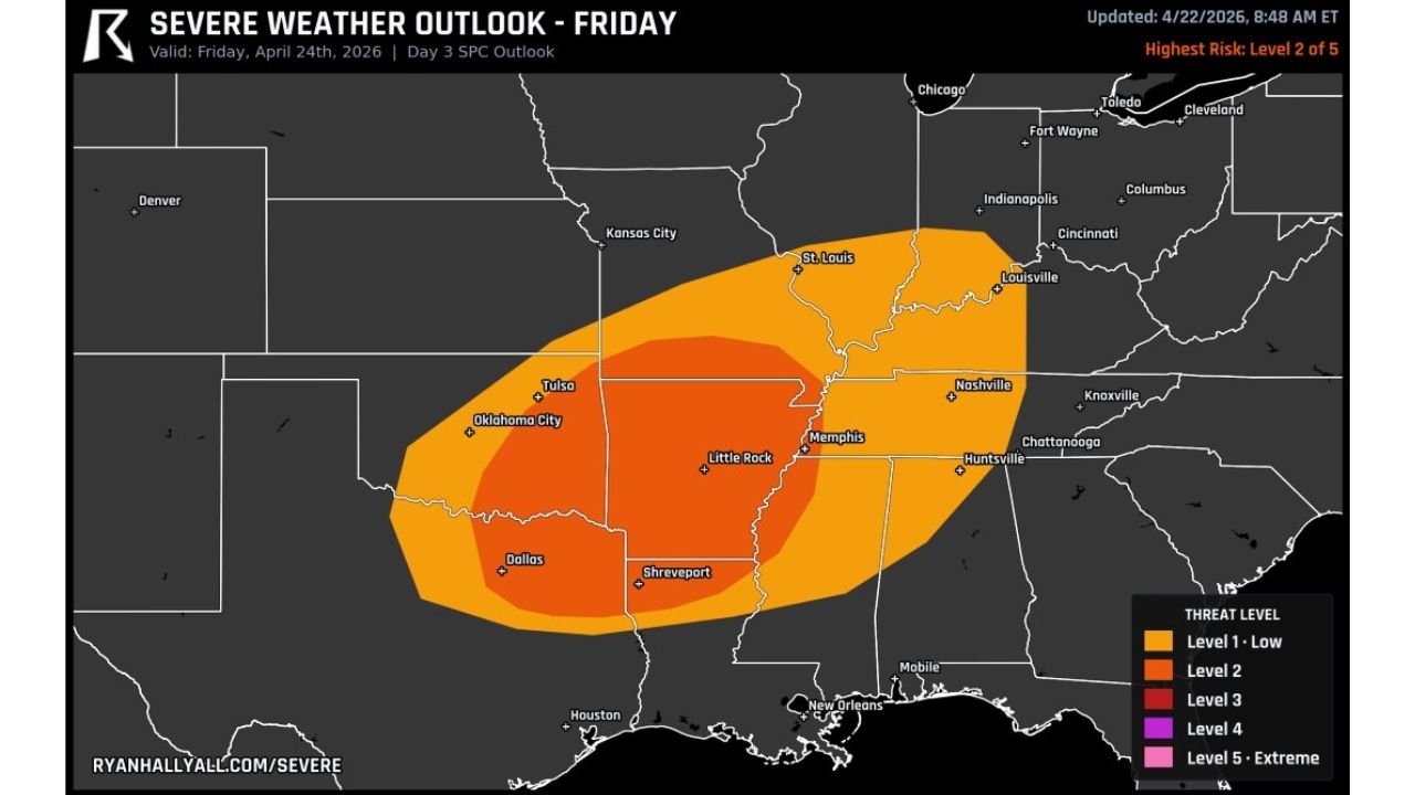
LITTLE ROCK, AR — A significant severe weather system is bearing down on the mid-South and Ohio Valley for Friday, April 24, 2026, and the outlook updated April 22 places a Level 2 Slight Risk — the highest designation in Friday’s outlook — directly over a densely populated corridor stretching from Oklahoma City and Dallas northeastward through Little Rock, Memphis, St. Louis, Louisville, and Nashville.
Strong storms capable of hail and high winds will develop Friday afternoon and track southeast through the overnight hours, keeping the threat active well past dark across Arkansas, Tennessee, Missouri, and Kentucky.
What the Friday Outlook Shows
The SPC Day 3 Outlook for Friday, April 24 carries a highest risk of Level 2 of 5 — shown in the darker orange core on the risk map — centered over Arkansas, western Tennessee, southern Missouri, and into southern Illinois. A broader Level 1 Low Risk zone surrounds the core, extending the threat outward to include Oklahoma City, Tulsa, Dallas, Shreveport, Nashville, Huntsville, and approaching Cincinnati and Indianapolis.
The storm development timing is Friday afternoon, with the system tracking southeast through the overnight period. This overnight movement is a critical detail — storms that develop in the afternoon hours and continue through the night reduce warning lead times and catch residents off guard who may already be asleep when the most organized storm activity arrives.
Threat and Risk Summary
| Risk Level | Zone | Key Cities |
|---|---|---|
| Level 2 — Slight Risk | Core zone | Little Rock, Memphis, St. Louis, Louisville |
| Level 1 — Low Risk | Broader corridor | Oklahoma City, Dallas, Tulsa, Nashville, Huntsville, Shreveport |
| Primary Threats | Hail and high winds | Full risk corridor |
| Storm Motion | Southeast through overnight | Friday afternoon into Friday night |
State-by-State Breakdown
Arkansas Little Rock sits squarely inside the Level 2 core zone for Friday. Arkansas has been repeatedly identified as a focus area for the late April severe weather pattern, and Friday delivers another organized threat across the state. Hail and damaging wind gusts are the primary concerns, with storm activity developing during the afternoon and continuing southeast through the night.
Tennessee Memphis falls inside the Level 2 core and Nashville sits within the Level 1 broader zone. The overnight southeastward storm track keeps Tennessee in the active weather corridor well into Friday night. Residents in both cities should have weather alerts active before going to bed Friday evening.
Missouri St. Louis is positioned at the northern edge of the Level 2 core zone, placing it among the highest-risk cities in Friday’s outlook. Storm development pushing out of Arkansas and Oklahoma will track through Missouri during the afternoon and early evening hours.
Kentucky Louisville falls inside the Level 2 core zone on Friday’s map. The Ohio Valley corridor through Kentucky remains in the active severe weather pattern that has characterized the final week of April across the mid-South and Midwest.
Oklahoma and Texas Oklahoma City, Tulsa, Dallas, and Shreveport all fall within the Level 1 broader risk zone. Storm initiation across eastern Oklahoma and north Texas Friday afternoon will feed organized severe weather into the Arkansas and Missouri corridor as the system tracks northeast.
Alabama Huntsville sits at the southeastern edge of the Level 1 zone. Northern Alabama should monitor Friday’s storm development closely, particularly given the broader severe weather pattern targeting the state both Monday and potentially again by May 1.
Forecast Confidence
Confidence: Moderate. The geographic placement of Friday’s risk zone is well-supported in the current Day 3 outlook, and the storm development timing of Friday afternoon is consistent across available guidance. The primary uncertainty involves exactly how organized the storm mode becomes — discrete supercells would maximize hail and tornado potential while a squall line would shift the primary threat toward widespread damaging winds. The overnight southeastward storm track is a consistent feature and means residents across Arkansas, Tennessee, Missouri, and Kentucky need weather alert sources active through the overnight hours Friday, not just during the afternoon.
More severe weather coverage is always on the horizon. Stay informed at ChicagoMusicGuide.com — your source for mid-South and Ohio Valley storm tracking across Arkansas, Tennessee, Missouri, and the entire United States.