Eastern Kansas and Northern Oklahoma Face EF-2 Tornadoes and 3-Inch Hail Thursday as Supercells Erupt Near Wichita Before Organizing Into a Dangerous Wind-Producing Line Tonight
WICHITA, KS — Thursday’s severe weather outbreak across eastern Kansas and northern Oklahoma is underway, and the threat profile is as serious as any event this spring. Supercells are firing across eastern Kansas this afternoon, tracking southward toward the Kansas-Oklahoma border through the evening, with initial storms capable of producing very large hail of 2 to 3 inches in diameter and several tornadoes — potentially EF-2 or stronger — before the storm mode transitions to a damaging wind-producing squall line by early tonight.
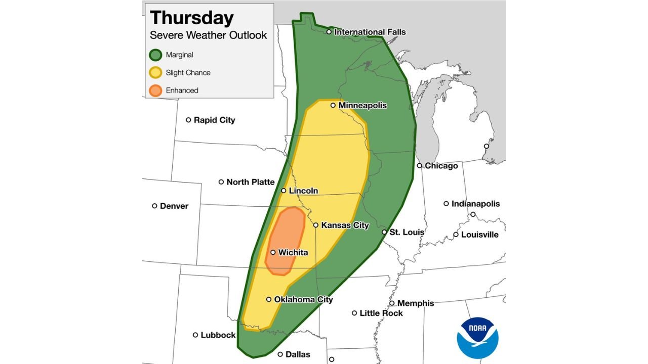
The Enhanced Risk bullseye sits directly over Wichita and the surrounding south-central Kansas corridor — the highest-risk designation in Thursday’s outlook and the zone where all three major severe hazards converge simultaneously.
Thursday’s Three-Phase Severe Weather Sequence
Phase 1 — Supercell Development: This Afternoon Severe storms are forming across eastern Kansas this afternoon. Initial discrete supercells — isolated rotating thunderstorms — are the most dangerous storm type for the opening hours of this event. These storms have access to the full energy of the loaded atmosphere and are capable of producing 2 to 3-inch hail and EF-2 or stronger tornadoes before any storm interaction occurs. The Wichita corridor is in the direct path of this supercell development phase.
Phase 2 — Southward Expansion: This Evening Storm development extends southward toward the Kansas-Oklahoma border through the evening hours. Oklahoma City and northern Oklahoma will see severe storm activity increase through the evening as the supercell cluster expands southward along the dryline and warm front boundaries.
Phase 3 — Squall Line Transition: Early Tonight By early tonight, the discrete supercells are expected to consolidate into a line of storms pushing into northern Oklahoma. When this transition occurs, the tornado and giant hail threat decreases while the widespread damaging wind threat increases significantly. The squall line phase will affect a broad area from Kansas City and Lincoln southward through Oklahoma City.
Thursday Severe Weather Risk Zones
| Risk Level | Zone | Key Cities |
|---|---|---|
| Enhanced — Level 3 | Core bullseye | Wichita, south-central Kansas |
| Slight — Level 2 | Broad corridor | Kansas City, Lincoln, Minneapolis fringe, Oklahoma City |
| Marginal — Level 1 | Outer zone | Dallas, Chicago fringe, Minneapolis, International Falls |
Threat Timeline Summary
| Threat | Timing | Zone |
|---|---|---|
| Supercell tornadoes EF-2+ | This afternoon | Eastern Kansas, Wichita |
| Hail 2 to 3 inches | This afternoon into evening | Wichita, Kansas-Oklahoma border |
| Southward storm expansion | This evening | Kansas-Oklahoma border |
| Squall line wind damage | Early tonight | Northern Oklahoma, eastern Kansas |
| Line continues | Tonight | Kansas City, Oklahoma City corridor |
State-by-State Breakdown
Kansas — Wichita and Eastern Corridor Wichita is at the center of the Enhanced Risk zone and faces the highest combination of tornado, hail, and wind threats of any location in Thursday’s outlook. EF-2 or stronger tornadoes and 2 to 3-inch hail are both credible outcomes from the initial supercell phase this afternoon. Residents across Wichita and surrounding south-central Kansas communities must be sheltered before storms arrive and maintain shelter through the squall line wind phase tonight.
Kansas — Kansas City Corridor Kansas City falls inside the Slight Risk zone. Severe thunderstorms with large hail and damaging winds are expected as the storm system tracks through the Kansas City area through the evening and tonight. The squall line phase will bring the most widespread impacts to this corridor.
Nebraska — Lincoln Lincoln falls inside the Slight Risk corridor. Damaging winds and large hail are the primary threats as storms push northward through Nebraska through the evening hours.
Oklahoma — Oklahoma City and Northern Oklahoma Oklahoma City sits inside the Slight Risk zone with the squall line expected to push into northern Oklahoma early tonight. Widespread damaging winds will be the dominant threat by the time storms reach Oklahoma City, though tornadoes remain possible in any supercell that maintains discrete structure ahead of the line consolidation.
Minnesota — Minneapolis Minneapolis falls within the outer Slight Risk zone on the northern extent of Thursday’s outbreak. Severe thunderstorms are possible across Minnesota as the system tracks north, with damaging winds and large hail the primary concerns.
Texas — Dallas Dallas sits in the Marginal Risk outer zone. Isolated severe thunderstorms are possible but widespread organized severe weather is not expected across north Texas on Thursday.
Forecast Confidence
Confidence: High for the overall severe weather event across eastern Kansas and northern Oklahoma Thursday. The supercell development this afternoon near Wichita is already underway and confirmed by current radar. The EF-2 or stronger tornado potential during the initial supercell phase carries strong forecaster confidence given the atmospheric environment in place. The transition to squall line mode by early tonight is well-supported and will bring the damaging wind threat to a much broader area than the initial supercell phase.
All residents across Wichita, Kansas City, Oklahoma City, Lincoln, and the broader corridor should be sheltered with weather alerts active and remain weather-aware through tonight as the squall line pushes through.
More live severe weather coverage is always on the horizon. Stay informed at ChicagoMusicGuide.com — your source for tornado and outbreak tracking across Kansas, Oklahoma, Nebraska, and the entire United States.