Violent Tornado Destroys Homes Near Vance Air Force Base South of Enid, Oklahoma as Damage Survey Begins
ENID, OK —A violent tornado carved a path of destruction across the southern edge of Enid, Oklahoma on April 23, 2026, leaving entire homes flattened in the Gray Ridge neighborhood and sending multiple people to the hospital. The storm tracked dangerously close to Vance Air Force Base, one of the U.S. Air Force’s primary pilot training installations, adding a layer of national security concern to what was already a catastrophic local event.
The tornado did not warn gently. It arrived with force.
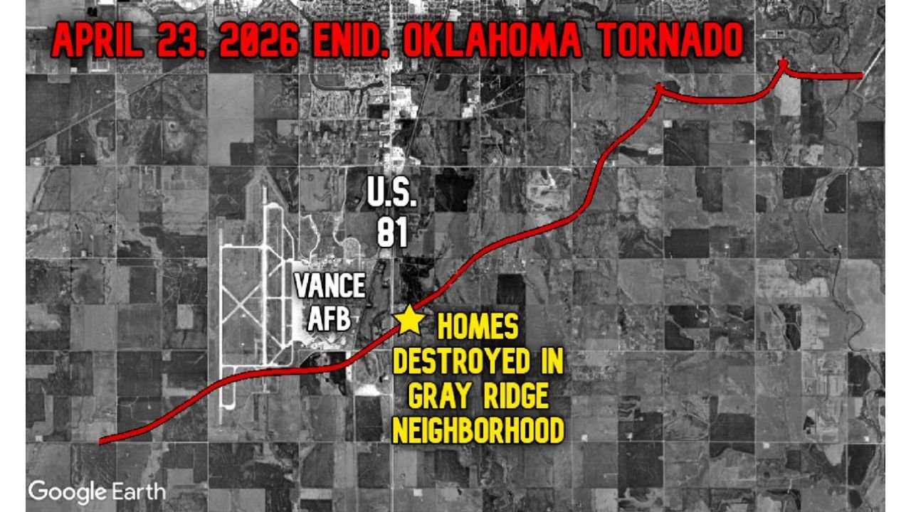
Aerial analysis of the storm’s ground track confirms this was no ordinary twister. The tornado path stretched across open farmland south of Enid before driving directly through a residential zone, where the damage was described as complete structural destruction. In the Gray Ridge neighborhood, homes were not just damaged — they were obliterated down to their foundations. Multiple injuries have been reported, and emergency response teams were deployed throughout the night.
Breaking Down the Storm Track
Storm track data confirms the tornado originated southwest of Enid and moved in a northeast to east-northeast direction, a classic tornado motion for central Oklahoma supercells in late April. The path ran adjacent to U.S. Highway 81 and clipped the eastern perimeter of Vance Air Force Base before driving directly into the Gray Ridge residential community.
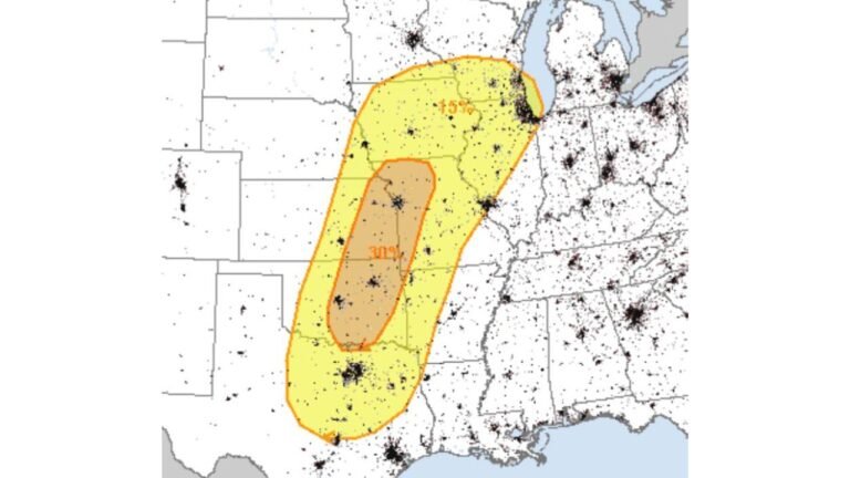
The distance and width of the ground track, combined with reports of complete home destruction, are consistent with what damage meteorologists classify as a violent tornado — a storm capable of producing winds that can exceed 150 to 200+ miles per hour. The EF scale, which stands for the Enhanced Fujita scale and rates tornadoes from EF0 (weakest) to EF5 (most destructive), will be the framework used by surveyors to officially rate this storm. An EF2 or higher rating requires winds of at least 111 mph, while EF4 and EF5 storms can level even well-constructed homes.
The National Weather Service office in Norman, Oklahoma is expected to deploy a damage survey team to assess the destruction and assign a preliminary EF rating. That rating — anticipated within 24 to 48 hours — will determine the official intensity of this event for the historical record.
Tornado Data at a Glance
| Data Point | Detail |
|---|---|
| Event Date | April 23, 2026 |
| Location | South of Enid, Garfield County, OK |
| Path Direction | Southwest to Northeast |
| Key Landmark | Vance Air Force Base (adjacent) |
| Primary Impact Zone | Gray Ridge Neighborhood |
| Structural Outcome | Complete home destruction confirmed |
| Injuries | Multiple reported |
| EF Rating | Pending NWS Norman damage survey |
| Survey Timeline | Expected within 24–48 hours |
Area-by-Area Damage Assessment
🔴 Gray Ridge Neighborhood, Enid, OK — Direct hit confirmed. Multiple homes completely destroyed. This is the epicenter of the damage corridor and the highest priority zone for search, rescue, and structural assessment.
🔴 Vance Air Force Base vicinity — Storm track passed immediately adjacent to base property. Damage to base infrastructure remains under assessment.
🟠 South Enid residential and rural corridors — Storm entry zone. Potential structural damage to farm buildings, outbuildings, and rural properties along the southwest portion of the track.
🟠 U.S. Highway 81 corridor — Tornado crossed or tracked near this major north-south artery. Road debris, downed power lines, and structural hazards possible.
🟡 Garfield County, OK (broader) — Secondary damage possible from the parent supercell’s wind field and associated hail. Residents should assess property carefully.
🟢 Kay and Major Counties, OK — In the general storm environment but not in the direct track of this specific tornado. Monitor for additional storm activity.
🔵 Northern Oklahoma (broader region) — Severe weather environment remains active. Additional tornado-warned storms possible in the 24-hour window following this event.
Forecast Confidence
The storm track and destruction zone shown in current analysis are confirmed based on aerial and ground observation data. Confidence in the path location is HIGH. The EF rating remains pending and will not be confirmed until NWS Norman completes their on-site damage survey. Confidence in a rating of EF2 or higher is moderate to high based on the structural destruction observed in the Gray Ridge neighborhood.
What Comes Next
This event is not over from a human impact standpoint. Dozens of families in the Gray Ridge area face an uncertain road ahead, with homes gone and recovery just beginning. As the NWS Norman survey team works to assign an official rating, local emergency management in Garfield County and the city of Enid will be coordinating shelter, utilities, and damage assessments throughout the coming days.
Oklahoma sits at the core of Tornado Alley, the geographic corridor stretching from Texas through Kansas where atmospheric conditions — warm Gulf moisture, dry western air, and powerful jet stream winds — regularly combine to produce violent rotating thunderstorms. Late April represents one of the most active periods of the tornado season for this region.
The people of Enid are resilient. But today, the storm won.
More severe weather coverage is always on the horizon. Stay informed at ChicagoMusicGuide.com — your source for tornado, storm damage, and breaking weather coverage across the Great Plains and the entire United States.