Morning Storm Chaos Over Illinois Threatens to Collapse Monday Severe Weather Setup as Cluttered Convection Raises a Major Wildcard
CHICAGO, IL — Before the afternoon storm chase even begins, the morning is already throwing a wrench into the forecast. Latest model data shows a sprawling, disorganized mass of convection — thunderstorm activity — draped across Illinois and stretching into neighboring states early Monday, April 27, and the concern among forecasters is real: if this morning mess does not clear out in time, the entire severe weather environment for the afternoon and evening could be significantly degraded.
This is one of the most difficult forecasting situations meteorologists face. Not too little storm activity — too much, too early, in all the wrong places.
What the Model Data Is Showing
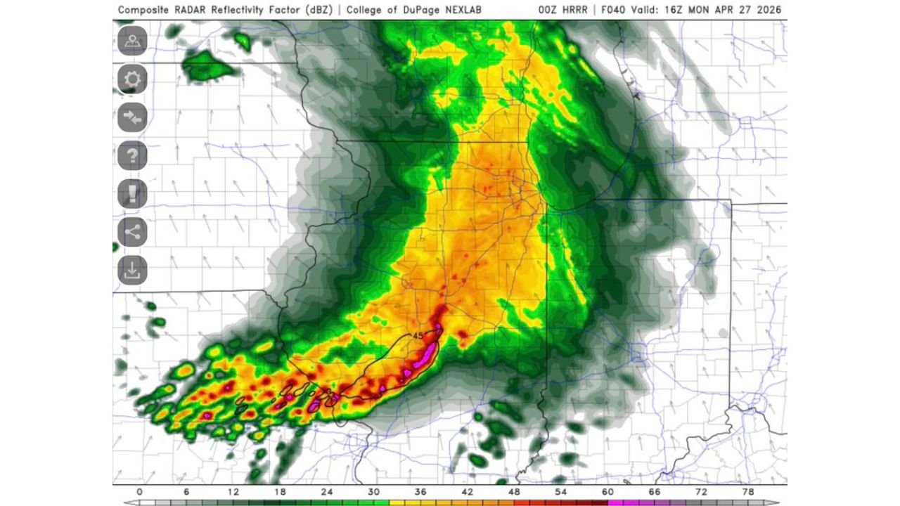
High-resolution model output valid for 16Z Monday, April 27, 2026 — that is late morning into the early afternoon hours in Central time — shows composite radar reflectivity values lighting up across a broad swath of central and southern Illinois. Reflectivity, measured in decibels of Z (dBZ), is the radar measurement of how much precipitation is in the atmosphere. Values shown in orange and red on the display are reaching into the 48 to 60+ dBZ range, which indicates heavy rainfall and potentially embedded thunderstorms already in progress across the state.
The magenta and pink returns visible near the southern end of the corridor are the most intense cores, pushing past 65 dBZ — the threshold associated with very heavy rain, large hail, and damaging wind potential within those individual cells.
The problem is not the intensity of any single storm. The problem is the coverage. When convection becomes this widespread and cluttered across a region before the prime severe weather window opens, it consumes the instability in the atmosphere that afternoon supercells need to develop. It also creates outflow boundaries — invisible lines of cooler, disturbed air left behind by collapsing storm clusters — that can disrupt wind shear patterns and prevent organized rotating storms from forming later in the day.
The 48-Hour Model Picture and What It Means for Tuesday
By the time the model advances to 00Z Tuesday, April 28 — which is Sunday evening local time — the storm picture has shifted dramatically. The broad convective mass that dominated Illinois has broken apart and reorganized into a more scattered, multi-corridor pattern. Activity is showing up across parts of Missouri, Arkansas, the lower Mississippi Valley, and into portions of Indiana and Ohio.
Notably, the Tuesday frame shows isolated intense cells with magenta returns reappearing across the southern tier of the outlook area, suggesting that even after the Monday convective mess exits, a second round of storm potential follows closely behind for the region. This is a pattern that will require close monitoring through the overnight hours Monday into Tuesday morning.
The Illinois Wildcard Explained
Current analysis indicates the Storm Prediction Center has maintained an Enhanced Risk — Level 3 of 5 — for the Illinois severe weather event despite what the morning model run is showing. That is a calculated and defensible decision. Here is why.
Morning model runs, particularly high-resolution short-range guidance, are known to sometimes overdevelop convection in the early hours of an event. The atmosphere on Monday afternoon could still recover. If the morning storm cluster moves through faster than modeled, or if a clear slot develops along the dry line pushing from the west, the instability can rebuild rapidly. Afternoon severe weather would then be very much in play for central and northern Illinois.
The wildcard, however, cuts both ways. If the morning convection lingers, expands, or fires additional clusters through midday, the afternoon severe weather window could be severely limited — tornado and large hail potential would drop considerably even if the overall storm threat remains.
Model Comparison Table
| Model Frame | Valid Time | Key Finding | Illinois Impact |
|---|---|---|---|
| 00Z HRRR F040 | 16Z Mon Apr 27 | Dense cluttered convection, 48-65+ dBZ cores | Morning storms consuming instability |
| 00Z HRRR F048 | 00Z Tue Apr 28 | Broken, scattered pattern, isolated intense cells | Convection reorganizing, second round possible |
| SPC Maintained Risk | Monday Day 1 | Enhanced Risk held despite morning convection | High uncertainty, wildcard event |
Area Impact Assessment
Illinois — Highest uncertainty of any state in today’s setup. Morning convection is the defining factor. If it clears, afternoon severe weather including tornadoes and large hail is possible. If it does not clear, the threat drops sharply. All residents should remain weather-aware through the entire day, not just the afternoon.
Missouri — Sits on the western edge of the convective corridor. Storm initiation timing will depend heavily on dry line position. Hail and wind threats remain in play.
Indiana and Ohio — Eastern fringe of the system. The overnight and early Tuesday model frame shows storm activity pushing into this corridor. Residents should monitor Tuesday morning conditions closely.
Arkansas and the Lower Mississippi Valley — The reorganized storm pattern in the 48-hour frame targets this region for a renewed round of convection into Tuesday. Hail and wind remain the primary threats.
Forecast Confidence
Confidence in storm coverage for Monday across Illinois is LOW to MODERATE due specifically to the morning convection wildcard. Confidence that at least some severe weather occurs somewhere in the broader region is HIGH. Confidence in the Tuesday reorganization and second-round storm threat is MODERATE. This forecast will evolve significantly through Monday morning as the convective situation clarifies.
Check back frequently. When a wildcard event like this is in play, the difference between a significant outbreak and a washout can come down to a few hours of morning storm behavior.
More severe weather coverage is always on the horizon. Stay informed at ChicagoMusicGuide.com — your source for storm-by-storm tracking, model analysis, and breaking severe weather coverage across Illinois, the Midwest, and the entire United States.