Monday Looks Beautiful Across Minnesota and Wisconsin Right Now But Do Not Be Fooled Because an Enhanced Risk Severe Weather Outbreak Will End That Fast Once Storms Erupt This Afternoon
MINNEAPOLIS, MN — Monday morning across Minnesota, Wisconsin, Iowa, and the Upper Midwest is delivering exactly the kind of spring day that makes people want to be outside — comfortable temperatures, pleasant skies, and air that feels genuinely refreshing after a busy stretch of weather. The nice weather outlook for Monday, April 13, 2026 shows a broad corridor of fair to nice conditions draped across the same region currently sitting under an Enhanced Risk severe weather outlook.
That overlap is not a coincidence — and it is not a reassurance. It is a warning.
The Dangerous Deception of a Nice Morning Before a Severe Weather Afternoon
The pleasant morning conditions across the Upper Midwest today are a direct product of the same atmospheric setup that will produce dangerous severe thunderstorms later this afternoon and evening. The warm, moist air flooding northward into Minnesota, Wisconsin, and Iowa is what makes the morning feel so comfortable — dewpoints are elevated, temperatures are mild, and the sky is not yet showing the signs of what is building.
But that same warmth and moisture is the fuel. Once storm initiation occurs this afternoon, the energy that made the morning feel so pleasant becomes the engine that powers violent thunderstorm updrafts capable of producing large hail, damaging winds, and tornadoes.
The message from current analysis is direct: enjoy the morning if you must, but be indoors with a shelter plan active before storms arrive. When these storms start, the transition from nice to dangerous will be fast.
What the Severe Weather Outlook Shows for Today
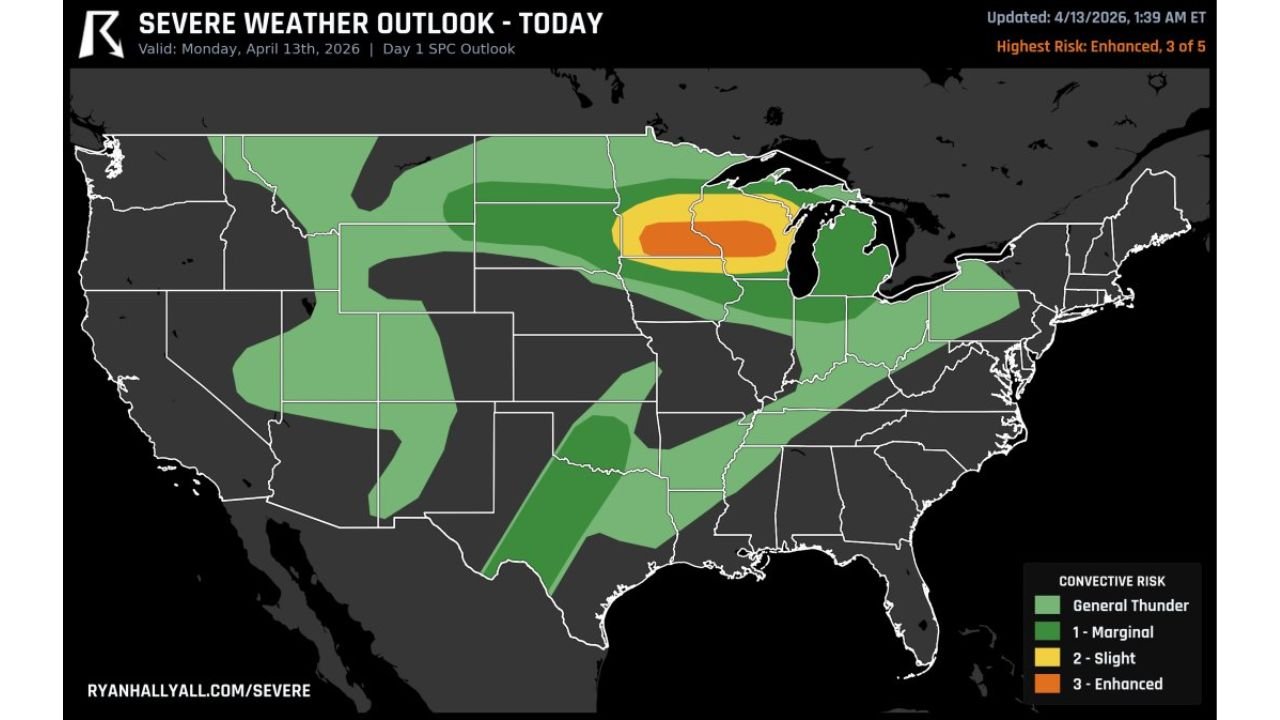
The SPC Day 1 Severe Weather Outlook valid for Monday, April 13, 2026 carries a highest risk designation of Enhanced — Level 3 of 5 across the core of the Upper Midwest. The Enhanced zone is centered over southern Minnesota, northern Iowa, and Wisconsin, with a Slight Risk zone surrounding it that extends the threat into Nebraska, Illinois, Indiana, Ohio, and portions of the mid-Atlantic and Northeast corridor.
A Marginal Risk covers an even broader area including Oklahoma, Kansas, Missouri, Kentucky, Tennessee, and extending northeast toward New England.
The severe weather threat map and the nice weather map today share nearly identical geography across the Upper Midwest — the same communities waking up to comfortable Monday morning conditions are the same communities that need to be weather-alert and sheltered by this afternoon.
Severe Weather Outlook Summary for Monday April 13
| Risk Level | Zone | States and Regions |
|---|---|---|
| Enhanced Level 3 | Core bullseye | Southern Minnesota, Northern Iowa, Wisconsin |
| Slight Level 2 | Surrounding corridor | Nebraska, Illinois, Indiana, Ohio, Mid-Atlantic |
| Marginal Level 1 | Broad outer zone | Oklahoma, Kansas, Missouri, Kentucky, Tennessee, Northeast |
| General Thunder | Wide area | Great Plains fringe, Southeast, Pacific Southwest |
Where the Nice Weather Is and Where the Danger Begins
The nice weather outlook for today shows fair to nice conditions across a large swath of the country including Minnesota, Wisconsin, Iowa, the Dakotas, Kansas, Nebraska, Oklahoma, Texas, Tennessee, the Carolinas, Georgia, Florida, the mid-Atlantic, and Southern California. On any other day, that would be the entire story. Today it is only the first half.
The severe weather outlook places its Enhanced Risk bullseye directly over the nicest part of the Upper Midwest map. Minneapolis, Saint Cloud, Rochester, Eau Claire, Wausau, Green Bay, Des Moines, Waterloo, and Dubuque are all sitting in that overlap zone right now — communities that are experiencing genuinely pleasant Monday morning conditions that will be replaced by dangerous severe thunderstorms this afternoon.
State-by-State Breakdown
Minnesota Comfortable and fair this morning. Enhanced Risk this afternoon. The transition will not be gradual — once storms fire across southern Minnesota, they will intensify quickly in the loaded warm sector environment. Minneapolis, Saint Cloud, Mankato, and Rochester residents should be watching conditions closely and have a shelter plan ready before noon.
Wisconsin Similar story to Minnesota. Pleasant morning conditions give way to Enhanced Risk severe weather this afternoon and evening across Eau Claire, Wausau, Green Bay, Madison, and Milwaukee. Large hail is the primary threat driver, with damaging winds and tornadoes also possible once supercells organize.
Iowa Iowa sits inside the Enhanced and Slight Risk corridor today. Des Moines, Cedar Rapids, Waterloo, and Dubuque all face severe weather potential this afternoon. The nice morning weather across Iowa today should not be interpreted as a sign that storms will not develop — the pleasant conditions are part of the same atmospheric setup driving the severe weather risk.
Illinois and Indiana Northern Illinois including Chicago, Rockford, and the Indiana border region fall inside the Slight Risk zone today. Organized severe thunderstorms capable of producing large hail and damaging winds are possible this afternoon and evening across these states.
Nebraska, Kansas and Oklahoma A separate corridor of Marginal to Slight Risk activity is indicated across the central Plains from Nebraska through Kansas into Oklahoma. Storm initiation here is more conditional, but the warm sector moisture across central and eastern Oklahoma is exceptionally deep with mid to upper 60s dewpoints — any storm that fires in this environment carries significant hail and tornado potential.
Forecast Confidence
Forecast Confidence: Moderate to High for the Upper Midwest Enhanced Zone. The overlap between today’s nice weather outlook and the Enhanced Risk severe weather outlook is one of the most important things to understand about Monday, April 13. The pleasant morning is real. The dangerous afternoon is equally real. Do not let one fool you into underestimating the other.
Residents across Minnesota, Wisconsin, Iowa, and northern Illinois need to be indoors, weather-alert, and shelter-ready before storm development begins this afternoon.
More severe weather and outbreak coverage is always on the horizon. Stay informed at ChicagoMusicGuide.com — your source for Enhanced Risk and severe storm tracking across Minnesota, Wisconsin, Iowa, Illinois, and the entire United States.