SPC Issues Mesoscale Discussion for Central Oklahoma and the Red River Valley of Texas as Baseball-Sized Hail and Tornadoes Become Possible This Afternoon With a Severe Watch at 60 Percent Probability
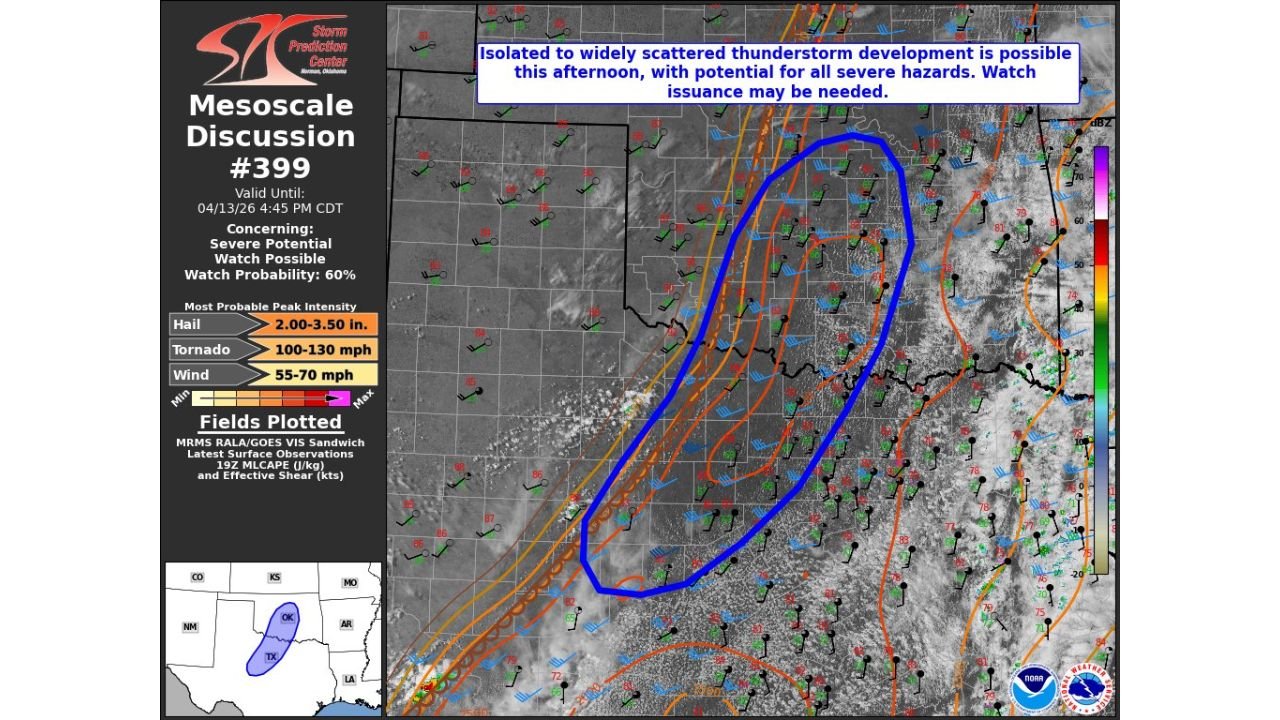
OKLAHOMA CITY, OK — The Storm Prediction Center has issued Mesoscale Discussion 399, valid until 4:45 PM CDT on April 13, 2026, targeting central Oklahoma and the Red River Valley of Texas — and the language inside that discussion is direct enough to demand immediate attention from anyone living across this corridor this afternoon.
A Mesoscale Discussion is the formal step the Storm Prediction Center takes immediately before issuing a Severe Thunderstorm or Tornado Watch. It signals that forecasters are actively monitoring a situation they believe is deteriorating fast enough to warrant a watch in the near term. The watch probability attached to this discussion is 60% — meaning there is a better-than-even chance a formal severe weather watch is issued for this region before the afternoon is over.
What the Discussion Is Saying
The cap — the layer of warm air in the mid-levels of the atmosphere that has been suppressing storm development across Oklahoma and Texas today — is showing an increasing chance of breaking, at least on an isolated basis, along the dryline in central Oklahoma or the Red River Valley boundary between Oklahoma and Texas.
Current analysis confirms the warm sector across this region is primed to an exceptional degree. If the cap breaks and an isolated supercell can establish itself, the environment surrounding it is loaded enough to immediately produce baseball-sized hail and an isolated tornado.
The SPC discussion explicitly identifies the potential for isolated to widely scattered thunderstorm development this afternoon, with all severe hazards possible — hail, tornadoes, and damaging winds — from any storm that fires.
Peak Intensity Data From the Discussion
The most probable peak intensity values attached to Mesoscale Discussion 399 are among the most serious numbers the Storm Prediction Center attaches to any convective discussion:
Hail: 2.00 to 3.50 inches in diameter. To put that in perspective, a baseball measures approximately 2.9 inches in diameter. The upper end of today’s hail forecast is essentially baseball-sized — large enough to punch through vehicle roofs, shatter windows, destroy crops, and cause serious injury or death to anyone caught outdoors without shelter.
Tornado winds: 100 to 130 mph. This range corresponds to EF-1 to EF-2 tornado intensity on the Enhanced Fujita scale. An EF-1 tornado produces winds of 86 to 110 mph capable of damaging roofs and snapping trees. An EF-2 produces winds of 111 to 135 mph capable of destroying manufactured homes, uprooting large trees, and causing major structural damage to well-built homes.
Wind gusts: 55 to 70 mph. Straight-line wind gusts at this range are capable of downing power lines, snapping tree branches, and creating dangerous driving conditions across open highways.
Mesoscale Discussion 399 Data Summary
| Threat | Most Probable Peak Intensity | Significance |
|---|---|---|
| Hail | 2.00 to 3.50 inches | Baseball-sized, life-threatening if outdoors |
| Tornado Winds | 100 to 130 mph | EF-1 to EF-2 intensity range |
| Damaging Winds | 55 to 70 mph | Power line and tree damage threshold |
| Watch Probability | 60% | Better than even chance of formal watch |
| Valid Until | 4:45 PM CDT April 13, 2026 | Afternoon deterioration window |
Where the Threat Is Focused
The blue outlined polygon on the discussion map covers central Oklahoma — including the Oklahoma City corridor — extending southward through the Red River Valley into north-central Texas. This is the zone where the dryline is most likely to provide the trigger needed for isolated supercell development this afternoon.
Central Oklahoma — Oklahoma City Corridor Sits directly inside the Mesoscale Discussion polygon. The dryline across this region is the primary storm initiation boundary. Any storm that fires here this afternoon moves immediately into the primed warm sector with baseball hail and tornado potential. Oklahoma City residents should be monitoring conditions actively and have a shelter plan ready for immediate use.
Red River Valley — Southern Oklahoma and Northern Texas The boundary zone between Oklahoma and Texas along the Red River Valley is the second identified initiation focus in the discussion. Storms developing here would track northeastward into the primed warm sector environment. Communities across southern Oklahoma and north-central Texas including the Wichita Falls corridor are inside the risk zone.
North-Central Texas The southern extent of the discussion polygon reaches into north-central Texas. The same baseball hail and tornado potential applies to any supercell that develops along the dryline across this portion of Texas this afternoon.
Forecast Confidence
Forecast Confidence: Moderate. The issuance of a formal Mesoscale Discussion with a 60% watch probability by the Storm Prediction Center signals that forecasters have moved beyond a conditional monitoring posture into active pre-watch status for central Oklahoma and the Red River Valley. Storm initiation remains the primary uncertainty — the cap may hold through the afternoon without breaking. But the 60% watch probability and the extreme peak intensity values attached to this discussion mean residents across central Oklahoma, southern Oklahoma, and north-central Texas should treat this as an imminent threat situation rather than a distant possibility.
Do not wait for a watch or warning to be issued before moving to your shelter. By the time a tornado warning is active, storm development will already be underway.
More Mesoscale Discussion and severe weather watch coverage is always on the horizon. Stay informed at ChicagoMusicGuide.com — your source for SPC watch and warning tracking across Oklahoma, Texas, and the entire United States.