Why Monday’s Illinois Severe Weather Bust Was Built Into the Forecast From the Start as a Weak Upper-Level Wave Left Southern Illinois Without the Forcing It Needed
ST. LOUIS, MO — Monday’s severe weather event across Illinois underperformed relative to pre-event forecasts, and the post-analysis is pointing to a clear and specific atmospheric reason — one that was arguably baked into the setup from the very beginning. Current analysis indicates Monday’s event was synoptically handicapped from the start, meaning the large-scale atmospheric pattern itself was structurally insufficient to deliver the severe weather outbreak that the thermodynamic ingredients — the heat, the moisture, the instability — were otherwise capable of supporting.
This is the kind of forecast bust that does not reflect a failure of the local environment. It reflects a failure of the large-scale atmospheric machinery to provide the trigger those ingredients needed.
The Upper-Level Wave Problem
The core issue on Monday was the nature of the ejecting upper-level wave — the large-scale atmospheric disturbance moving across the country that was supposed to provide the forcing needed to lift air, break the cap, and ignite organized severe thunderstorms across southern Illinois and adjacent areas.
Upper-level waves — disturbances in the flow pattern at approximately 18,000 feet above the surface, known as the 500 millibar level — drive the large-scale ascent that initiates deep convection. Think of them as the atmospheric elevator that lifts surface air into the storm-producing layer of the atmosphere. When an upper-level wave is strong, it produces significant height falls — dropping pressure values at that level — which creates a powerful upward motion signal that can fire storms even against a resistant cap.
Monday’s wave was weak and flat. Current analysis of 500 millibar height change data — which measures how much the upper atmosphere dropped in pressure over the previous 12 hours, a direct proxy for how much forcing was being applied — tells the story clearly. The core of the favorable height falls only reached as far south as approximately St. Louis. Everything southeast of Interstate 44 — the zone where the most favorable thermodynamic environment existed, where the heat and moisture were richest — received generally limited forcing for ascent. The atmospheric elevator was running, but it did not reach the floors where the fuel was stored.
Why the Cold Pool Could Not Be Modified
A second compounding factor was the interaction between Monday’s morning storm system — a Mesoscale Convective System, or MCS, which is a large organized cluster of thunderstorms — and the afternoon severe weather window. Morning MCS activity deposits what meteorologists call a cold pool — a dome of cooler, stabilized air left behind at the surface after rainfall evaporates and cools the boundary layer. For the afternoon severe weather environment to recover, that cold pool needs to be eroded and modified by warming and increased low-level wind flow.
On a day with a strong upper-level wave, the low-level atmospheric response — warm air advection moving northward and stronger surface winds — can rapidly erode a morning cold pool and allow the severe weather environment to rebuild. Current analysis makes a direct comparison to the atmospheric setup of April 27, 2011 — one of the most violent tornado outbreak days in recorded history — where despite a similarly disruptive morning MCS, a powerful upper-level trough produced such a strong low-level response that the cold pool was rapidly eroded and the afternoon environment exploded into a catastrophic severe weather event.
Monday, April 27, 2026 did not have that strong trough. Without the stronger wave and stronger low-level response, Monday’s cold pool from the morning MCS could not be modified in time. The afternoon severe weather window never fully opened across southern Illinois the way the pre-event forecasts had hoped.
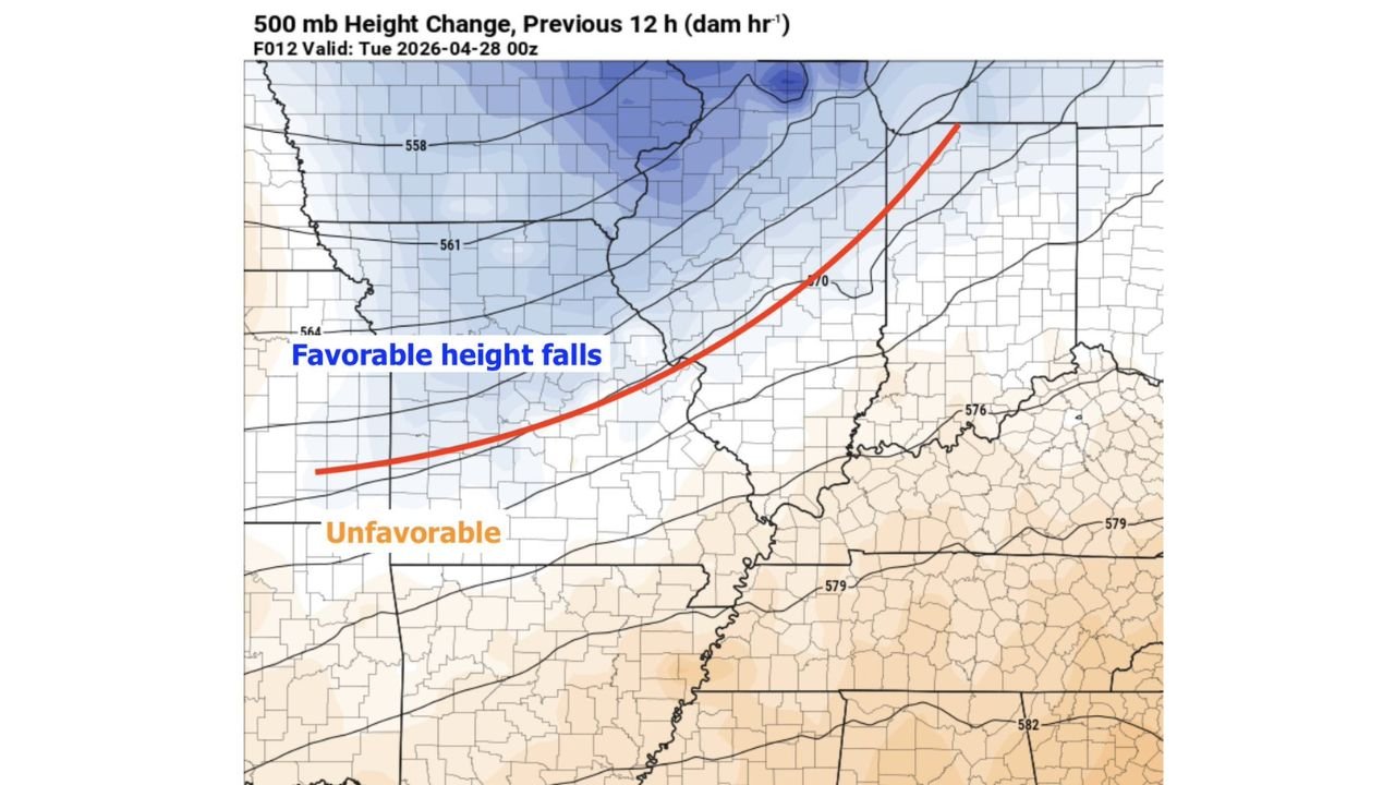
Reading the Upper-Level Height Change Map
The 500 millibar height change map valid for Tuesday, April 28 at 00Z shows the structural problem with stark clarity. The blue shading across northern Illinois, Iowa, and the upper Midwest represents favorable height falls — areas where the upper atmosphere dropped significantly over the previous 12 hours, indicating strong dynamic support for storm development in those zones. The favorable zone is clearly labeled and concentrated north of a boundary oriented roughly along the Interstate 44 corridor through Missouri.
South of that red boundary line — across southern Illinois, southern Missouri, Kentucky, Tennessee, and Arkansas — the map shows neutral to rising height values, shown in tan and labeled as unfavorable. This is the thermodynamically rich zone that was left without adequate upper-level support. The instability was there. The moisture was there. The wave was not strong enough or positioned far enough south to take advantage of either.
What This Means for Forecast Verification
| Factor | Expected | Actual | Impact |
|---|---|---|---|
| Upper-level wave strength | Strong, deep trough | Weak, flat ejecting wave | Insufficient forcing for ascent |
| Height falls south of I-44 | Significant | Limited — core stalled near St. Louis | Southern IL left without trigger |
| Cold pool modification | Rapid erosion after morning MCS | Slow — low-level response too weak | Afternoon environment never recovered |
| Comparison event (4/27/11) | Strong trough, rapid cold pool erosion | Strong trough delivered — outbreak occurred | Contrast highlights Monday’s deficiency |
| Southern Illinois severe weather | Major outbreak potential | Underperformed — bust relative to forecast | Synoptic handicap from the start |
The Broader Lesson for This Outbreak Sequence
Monday’s underperformance across Illinois is a reminder that even when the local thermodynamic ingredients — instability, moisture, wind shear — are exceptional, the large-scale atmospheric pattern must deliver adequate forcing to convert those ingredients into organized severe weather. The two components are not interchangeable. A rich thermodynamic environment sitting beneath a weak, poorly positioned upper-level wave will underperform every time relative to what the local data alone would suggest.
This distinction matters for forecast communication. Pre-event forecasts for Monday correctly identified the extraordinary instability and moisture across southern Illinois. What was more difficult to resolve at extended range was whether the upper-level wave would be strong enough and positioned far enough south to fully exploit that environment. It was not. The bust was, in retrospect, built into the synoptic pattern — it just was not clearly identifiable until the data came into sharper focus in the final 12 to 24 hours.
Forecast Confidence in Post-Analysis
Confidence in this post-event analysis is HIGH. The 500 millibar height change data clearly shows the structural deficiency that limited Monday’s severe weather potential across southern Illinois and southeast of Interstate 44. The cold pool modification argument is well-supported by comparison to historical analog events. This analysis does not diminish the real severe weather that did occur across other portions of the outbreak zone — it specifically addresses why southern Illinois underperformed relative to pre-event expectations.
Understanding why a forecast busts is just as important as getting it right. Monday’s synoptic handicap is a case study worth studying.
More severe weather coverage is always on the horizon. Stay informed at ChicagoMusicGuide.com — your source for severe weather analysis, forecast verification, and post-event meteorological breakdowns across Illinois, Missouri, and the entire United States.