Pacific Ocean Temperatures Are Climbing Fast Toward El Nino Conditions and the Trend Could Reshape United States Weather Patterns This Summer and Fall
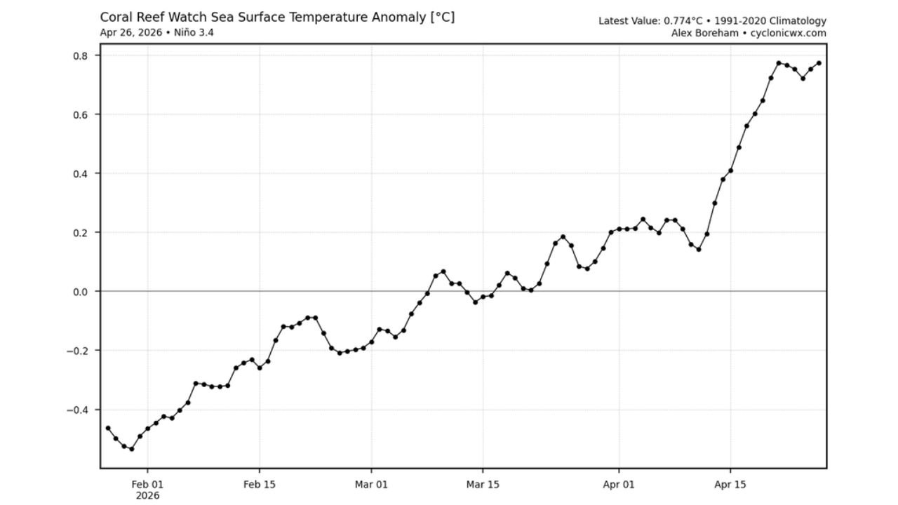
MIAMI, FL — Something significant is happening beneath the surface of the central Pacific Ocean — and it has direct implications for weather patterns across the entire United States. Sea surface temperatures in the Nino 3.4 region, the critical monitoring zone in the equatorial Pacific that defines El Nino and La Nina conditions, have been climbing steadily and are now sitting at +0.2 degrees Celsius above the long-term average according to official NOAA data. Other analysis methods are already showing values closer to +0.774 degrees Celsius — a reading that would place the Pacific in weak El Nino territory right now.
The direction of this trend is unambiguous. The question is no longer whether the Pacific is warming. The question is how far and how fast it goes from here.
What the Temperature Anomaly Data Shows
Current sea surface temperature analysis of the Nino 3.4 region — a defined box of ocean in the central equatorial Pacific, roughly between 120 and 170 degrees West longitude — shows the entire monitoring zone blanketed in above-normal water temperatures. The satellite-derived sea surface temperature map shows deep orange and red shading wall-to-wall across the Nino 3.4 box, with the +0.2 degrees Celsius anomaly value representing the official NOAA weekly assessment.
The anomaly chart tracking Nino 3.4 sea surface temperature departures from the 1991 to 2020 climatological baseline tells an even more compelling story through its trend line. Starting from a deeply negative -0.5 degrees Celsius in late January 2026 — firmly in La Nina territory — the anomaly has made a dramatic and nearly uninterrupted climb across the past three months. By April 26, 2026, the most current data point on the anomaly chart has reached +0.774 degrees Celsius, the highest value recorded in this dataset since at least the start of 2026.
That is a swing of more than 1.2 degrees Celsius in roughly 90 days. In ocean temperature terms, that is a rapid and significant transition.
What El Nino and La Nina Mean for the United States
El Nino and La Nina are the two phases of the El Nino Southern Oscillation — a naturally occurring climate pattern involving sea surface temperature fluctuations in the equatorial Pacific that drives significant shifts in weather patterns across the globe, including the United States.
During El Nino conditions — when the Nino 3.4 region runs +0.5 degrees Celsius or warmer above average for at least five consecutive overlapping three-month periods — the United States typically experiences a predictable set of climate shifts. The southern tier of the country, including California, Texas, the Gulf Coast, Florida, and the Southeast, tends to see wetter than normal conditions during El Nino winters. The northern tier including the Great Lakes, upper Midwest, and northern Plains tends to run warmer than normal. Atlantic hurricane activity typically decreases during El Nino years due to increased upper-level wind shear over the Gulf of Mexico and Caribbean.
La Nina — the opposite phase, with below-normal Pacific temperatures — tends to produce drier conditions across the southern United States, more active Atlantic hurricane seasons, and colder winters across the northern tier.
The transition currently underway from La Nina toward El Nino conditions has direct seasonal forecast implications for the coming months.
The Rapid Three-Month Trend in Context
The anomaly chart from February through late April 2026 documents one of the more rapid La Nina to El Nino transition sequences in recent memory. The trajectory broke out of negative territory around mid-March, crossed through neutral conditions, and has accelerated sharply through April — gaining roughly +0.5 degrees Celsius in the final three weeks of the chart alone.
This acceleration in the final weeks of April is the most critical signal in the dataset. Ocean temperatures do not accelerate this quickly without meaningful atmospheric reinforcement. Weakening trade winds — the easterly winds that normally push warm surface water away from the South American coast and keep cooler water upwelling — are likely contributing to the warm anomaly buildup in the Nino 3.4 zone. When trade winds weaken and allow warm water to pool in the central Pacific, it creates a self-reinforcing feedback that can push an emerging El Nino further and faster than initial readings suggest.
Nino 3.4 Temperature Trend Summary
| Date | Nino 3.4 Anomaly | ENSO Phase |
|---|---|---|
| Late January 2026 | -0.50°C | La Nina |
| Mid February 2026 | -0.35°C | La Nina weakening |
| Early March 2026 | -0.20°C | Transitioning toward neutral |
| Mid March 2026 | 0.00°C | Neutral |
| Early April 2026 | +0.10 to +0.20°C | Neutral to borderline warm |
| April 26, 2026 | +0.774°C (alt. analysis) | Borderline weak El Nino |
| Official NOAA current | +0.20°C | Neutral — trending warm |
| El Nino threshold | +0.50°C sustained | Weak El Nino begins |
What This Means for United States Weather Going Forward
The implications of a developing El Nino for the United States are significant across multiple sectors and regions.
Atlantic Hurricane Season — A weak El Nino developing through summer would increase upper-level wind shear over the Gulf of Mexico and Caribbean, which acts as a suppression mechanism for tropical storm and hurricane development. States along the Gulf Coast and East Coast — Florida, Texas, Louisiana, Georgia, the Carolinas, and Virginia — could see a less active hurricane season than the prior La Nina-dominated years if El Nino conditions consolidate by summer.
Summer Temperature and Drought Patterns — El Nino summers tend to run cooler than normal across the northern United States and Pacific Northwest, with warmer and drier conditions possible across the southern Plains and parts of the Southwest. Texas, Oklahoma, and the southern Rockies may face continued or expanded drought risk if El Nino strengthens through the summer months.
Fall and Winter Outlook — If El Nino reaches moderate strength by late 2026, the classic El Nino winter pattern would favor a wetter than normal fall and winter across California, the Gulf Coast, and Florida, while the northern tier runs warmer. Chicago and the Great Lakes region, Minnesota, and the northern Plains could see a milder winter than recent La Nina years.
Forecast Confidence
Confidence that the Nino 3.4 region is in or approaching weak El Nino conditions is MODERATE to HIGH based on the current temperature anomaly trend and rate of change. Official NOAA confirmation of El Nino status requires the +0.5 degree Celsius threshold to be sustained across multiple consecutive three-month periods — that official designation has not yet been made. Confidence in continued warming of the Nino 3.4 region through spring 2026 is HIGH based on the acceleration seen in April data. Confidence in the full seasonal forecast implications described above is MODERATE — El Nino’s effects on United States weather are probabilistic tendencies, not guarantees, and the strength of the eventual El Nino will determine how strongly those patterns express themselves.
This is a developing story that will shape United States weather from summer through winter 2026. Monitor closely.
More climate and severe weather coverage is always on the horizon. Stay informed at ChicagoMusicGuide.com — your source for El Nino tracking, seasonal forecast analysis, and breaking weather coverage across the entire United States.