Golf Ball to Softball-Sized Hail Falling Northeast of Springfield Missouri as Radar Data Confirms a Dangerous Giant Hail Core Over Fair Grove
SPRINGFIELD, MO — A severe thunderstorm is producing a prolific and dangerous hail core northeast of Springfield, Missouri right now, and dual-polarization radar data is painting one of the clearest giant hail signatures seen this storm season. Current analysis of multiple radar products centered on the Fair Grove area — northeast of Springfield along the Strafford and Northview corridor — confirms that hail ranging from golf ball to hen egg size is falling across the area, with softball-sized hail possible at the peak of the core.
This is not marginal severe hail. This is a high-confidence, life-safety hail event. Anything caught outside in this storm’s path right now is at serious risk of destruction.
What Four Radar Products Are Showing Simultaneously
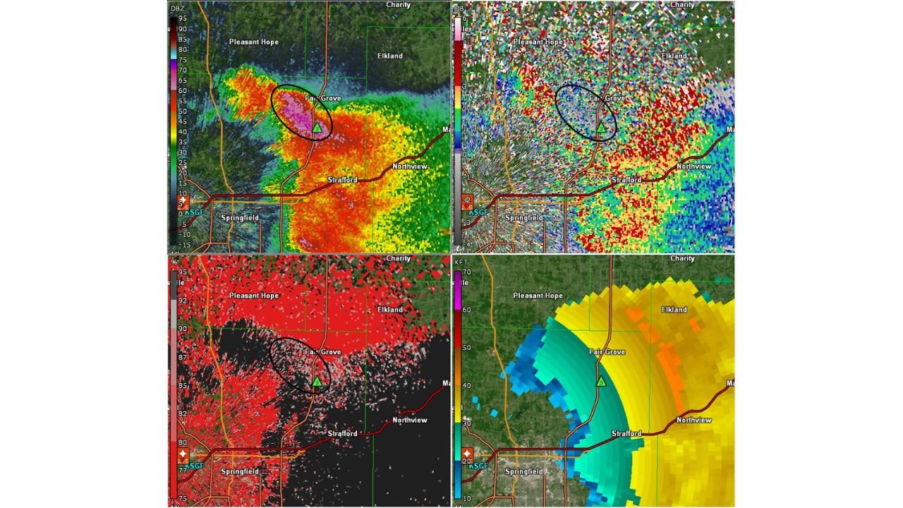
The four-panel radar display tells a comprehensive story that goes well beyond a single reflectivity scan. Each product contributes a different piece of the hail diagnosis, and all four are pointing to the same conclusion.
The reflectivity panel — the top left display showing standard radar returns measured in decibels of Z, or dBZ — shows a core of extremely high reflectivity values centered over Fair Grove. The magenta and purple colors visible inside the black circled zone on the reflectivity display indicate values pushing into the 70 to 75+ dBZ range. Standard rainfall rarely exceeds 55 dBZ. Values in the 70s are overwhelmingly associated with large to giant hail. The tight gradient on the northeastern edge of the core — where radar colors transition rapidly from high to lower values over a short distance — indicates a compact, intense hail shaft rather than a diffuse rain area.
The differential reflectivity, or ZDR, panel — top right — shows the chaotic and mixed signature characteristic of a hail environment. ZDR measures the difference in radar return between horizontal and vertical pulses. Rain drops flatten as they fall and produce positive ZDR values. Hailstones, which tumble irregularly and come in all shapes, produce low or near-zero ZDR. The mixed blues, reds, and whites visible in the circled zone confirm an environment with hail of all shapes and sizes falling simultaneously — tumbling irregularly, some coated in water, some dry — creating the chaotic radar return signature visible here.
The correlation coefficient, or CC, panel — bottom left — shows predominantly high values in deep red across most of the storm, indicating meteorological targets moving consistently. However, the presence of some lower CC values within the hail core zone, shown in darker pixels, signals non-meteorological targets — debris, large irregular hailstones, and chaotic tumbling ice that the radar cannot categorize cleanly. This is a known signature of very large hail and confirms the hail shaft analysis.
The velocity panel — bottom right — shows the storm’s wind field, with colors transitioning from green through yellow and into orange and red indicating increasing wind speeds away from the radar. The storm structure visible here is consistent with a rotating, organized severe thunderstorm with a well-defined updraft capable of suspending and growing large hailstones for extended periods before releasing them to the surface.
Understanding the Hail Size Estimates
Current analysis places hail sizes in the Fair Grove core at golf ball to hen egg range as the most likely output across the broadest area, with softball-sized hail possible at the peak intensity of the core. To put these sizes in physical context:
A golf ball measures approximately 1.75 inches in diameter and is capable of shattering vehicle windows, puncturing vinyl siding, destroying gutters, and causing serious injury to anyone caught outside without protection. A hen egg, roughly 2 inches, causes similar damage at higher velocity. A softball at 4.5 inches in diameter is among the largest hail sizes produced by severe thunderstorms and causes catastrophic damage to vehicles, roofing, skylights, and any exposed surface. Softball-sized hail falls at terminal velocities that can destroy a vehicle roof in seconds and is life-threatening to anyone caught in the open.
Radar Signature Summary Table
| Radar Product | Key Reading | Hail Indication |
|---|---|---|
| Reflectivity (dBZ) | 70 to 75+ dBZ in core | Extreme — giant hail range |
| Differential Reflectivity (ZDR) | Low, near-zero values in core | Tumbling hailstones confirmed |
| Correlation Coefficient (CC) | High with non-met targets present | Large irregular hail — debris signal |
| Velocity | Organized rotation, strong updraft | Storm capable of sustained hail growth |
| Hail Size Estimate | Golf ball to softball | Life-threatening giant hail possible |
Communities in the Impact Zone
Fair Grove, Missouri — Directly inside the hail core at time of analysis. This community is experiencing the most intense hail fallout from this storm right now. Vehicles, roofs, and any outdoor property are at extreme risk.
Strafford, Missouri — Positioned in the path of storm motion southeast of the core. Significant hail impact expected as the storm tracks through this corridor.
Northview, Missouri — Downstream of the current hail shaft. Large hail threat as the storm continues tracking northeast.
Pleasant Hope and Elkland, Missouri — Communities on the northern flank of the storm. Within range of the hail swath depending on storm track and core evolution over the next 15 to 30 minutes.
Springfield, Missouri — Located southwest of the current core. The primary storm threat has tracked northeast of the city, but residents on the northeast side of Springfield and those along the Springfield to Strafford corridor should be monitoring conditions closely as additional storm development is possible.
Forecast Confidence
Confidence in golf ball to hen egg sized hail falling across the Fair Grove and Strafford corridor right now is VERY HIGH. All four dual-polarization radar products are in clear agreement and the signatures are unambiguous. Confidence in softball-sized hail at the peak core is MODERATE to HIGH based on the extreme reflectivity values and low ZDR readings. The chaotic nature of the hail core — with mixed sizes and irregular shapes — means the largest stones may be intermixed with smaller hail across the same area.
If you are in Fair Grove, Strafford, or Northview — move vehicles into a garage immediately if possible. Do not go outside for any reason. Large hail at these sizes falls fast enough to cause serious injury and can kill. Stay inside and away from windows until the storm passes.
More severe weather coverage is always on the horizon. Stay informed at ChicagoMusicGuide.com — your source for live radar analysis, hail tracking, and breaking severe weather coverage across Missouri and the entire United States.