Severe Storms With Damaging Winds, Large Hail and Tornadoes Target the Deep South and Lower Ohio Valley Tuesday Night
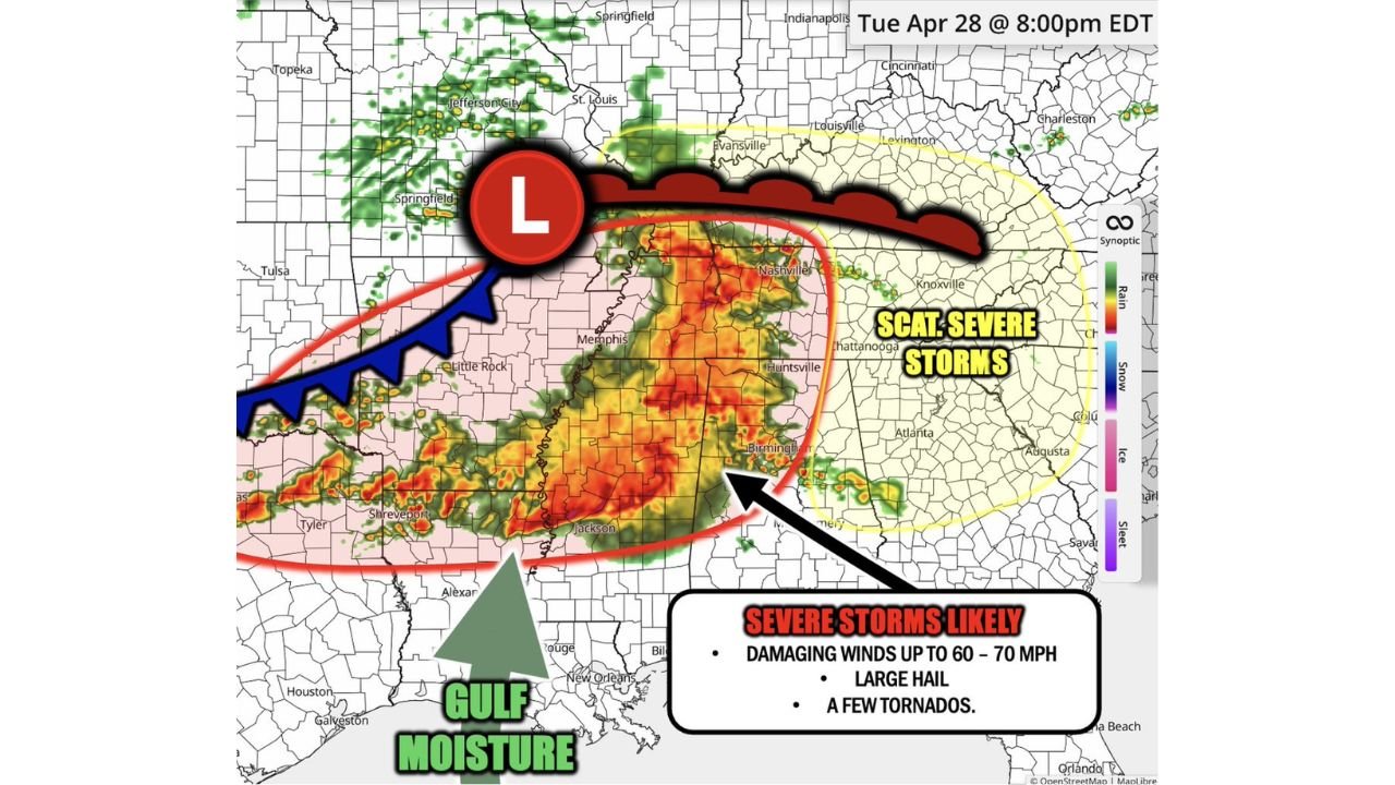
NASHVILLE, TN — The severe weather pattern gripping the central and southern United States is not letting up. Another round of dangerous storms is forecast to develop Tuesday evening and push through portions of the lower Ohio Valley, Deep South, and northeast Texas by 8:00 PM EDT on April 28, 2026, bringing a renewed threat of damaging winds up to 60 to 70 mph, large hail, and a few tornadoes to millions of residents who are still recovering from the weekend and Monday outbreaks.
The highest-risk zone — outlined in red on current simulation radar analysis — stretches from Little Rock, Arkansas eastward through Memphis, Nashville, Birmingham, and into central Alabama and Mississippi. This is where severe storms are considered likely, not just possible. Outside that red zone, scattered severe weather remains possible across a broader area including portions of Tennessee, Kentucky, Georgia, and northeast Texas.
What Is Driving Tuesday Night’s Storm Threat
A surface low pressure system is positioned near Springfield, Missouri at the valid time, with a cold front pushing southward and eastward through Arkansas and Missouri — shown on current analysis as the blue frontal boundary sweeping toward Little Rock and Shreveport. A warm front trails eastward from the low through southern Kentucky and Tennessee, running roughly toward Lexington and Charleston. The zone between these two boundaries — the warm sector — is where Gulf moisture streaming northward from the Gulf of Mexico is most concentrated and most unstable.
That Gulf moisture inflow, shown as a large green arrow on current analysis pushing north from the Houston-Galveston and New Orleans coastline, is the fuel source for Tuesday night’s storm complex. Warm, humid surface air with dewpoints in the upper 60s to low 70s Fahrenheit across Mississippi, Alabama, and Tennessee will feed directly into storm updrafts as the frontal system pushes east.
Threat Breakdown by Zone
The red-shaded highest-risk corridor covering Arkansas, Tennessee, Mississippi, and Alabama faces the full suite of severe weather hazards. Damaging winds of 60 to 70 mph are the primary threat across this zone, capable of downing trees, snapping power lines, and causing significant property damage across a wide area. Large hail — stones of at least one inch in diameter — is likely within organized storm cores. Tornadoes are possible, particularly where discrete supercell development occurs ahead of the main squall line in the warm sector.
The yellow-shaded scattered severe storm zone extending into Kentucky, Indiana, Ohio, Georgia, and portions of the Tennessee Valley faces a lower but real severe weather risk. Chattanooga, Knoxville, Atlanta, and Louisville all sit within or adjacent to this outer zone. Damaging wind gusts and large hail are the primary concerns here, with tornado potential lower but not zero.
Area Impact Summary
| Zone | States | Primary Threats |
|---|---|---|
| Highest Risk (Red) | AR, TN, MS, AL core | Winds 60-70 mph, large hail, tornadoes |
| Scattered Severe (Yellow) | KY, IN, GA, eastern TN | Damaging winds, hail, isolated tornado |
| Northeast Texas fringe | Tyler, Shreveport area | Heavy rain, isolated severe possible |
| Lower Ohio Valley | Evansville, Louisville | Wind and hail threat, evening timing |
Forecast Confidence
Confidence in a significant severe weather event across the red-shaded corridor from Arkansas through Alabama Tuesday evening is MODERATE to HIGH. The frontal forcing is well-defined and Gulf moisture is abundant. The primary uncertainty involves storm mode — whether discrete supercells or a squall line dominates will determine how significant the tornado threat becomes. Confidence in damaging winds as the leading hazard is HIGH. Tornado confidence is MODERATE for the highest-risk zone.
Tuesday night is not the time to be without a working weather alert system across Tennessee, Mississippi, Alabama, and Arkansas.
More severe weather coverage is always on the horizon. Stay informed at ChicagoMusicGuide.com — your source for storm tracking and breaking severe weather alerts across the Deep South and the entire United States.