Severe Weather Pattern Shifts to the Southeast United States for Early May Before Returning to the Plains in the Second Half of the Month
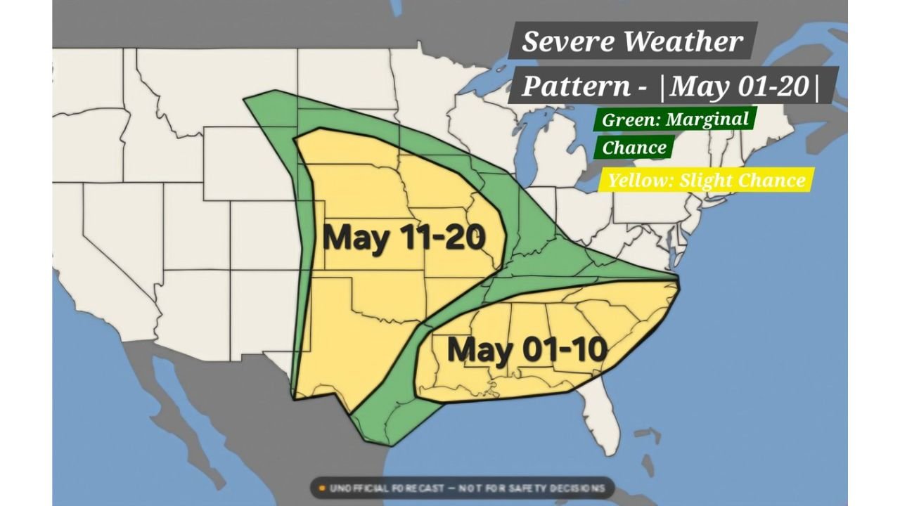
DALLAS, TX — After one of the most active severe weather stretches the central United States has seen this spring, the overall pattern is about to make a significant geographic shift. Current long-range analysis covering the May 1 through May 20 period shows the primary severe weather focus moving away from the Plains and into the Southeast United States during the first week of May, before flipping back toward the central and southern Plains during the middle to latter half of the month.
Two distinct severe weather windows are emerging in the extended pattern — each targeting different regions and each carrying its own set of hazards for millions of Americans.
May 1 Through 10 — The Southeast Window
The first half of May shifts the severe weather spotlight to the Southeast United States. Current pattern analysis places a Slight Chance severe weather zone — shown in yellow — across a broad corridor covering Texas, Louisiana, Mississippi, Alabama, Georgia, Tennessee, Arkansas, and the Florida Panhandle region during the May 1 through 10 period. A Marginal Chance zone in green expands the outer threat boundary northward into portions of Missouri, Kentucky, and the Ohio Valley.
This is a multi-state, multi-day setup rather than a single event. The Southeast pattern during early May is typically driven by progressive shortwave disturbances — smaller atmospheric waves that ride along the jet stream and periodically trigger organized convection across the warm, humid environment of the Gulf Coast states. Damaging winds, large hail, and isolated tornadoes are all possible during this window, with specific high-risk days still too far out to pinpoint precisely.
May 11 Through 20 — The Plains Return
The second half of the month brings the severe weather action back to familiar territory. Current analysis shows the Slight Chance zone shifting northwestward and centering on the central and southern Plains — covering Kansas, Oklahoma, Nebraska, Colorado, New Mexico, Texas, and adjacent states — during the May 11 through 20 window. The Marginal green zone surrounds this core, extending the general threat into the Midwest and upper Plains.
Mid-May on the Plains is climatologically one of the most active tornado periods of the entire year. The jet stream typically strengthens and dips southward during this window, combining with rich Gulf moisture to create the classic supercell environment that produces long-track tornadoes, very large hail, and significant wind events across Tornado Alley. While it is too early for specific event details at this range, the pattern trend pointing back toward the Plains for mid-May is consistent with what seasonal climatology would suggest for this time of year.
Pattern Summary Table
| Period | Primary Risk Zone | Risk Level | Key States |
|---|---|---|---|
| May 1 to 10 | Southeast US | Slight to Marginal | TX, LA, MS, AL, GA, TN, AR |
| May 11 to 20 | Central and Southern Plains | Slight to Marginal | KS, OK, NE, CO, TX, NM |
| Outer Marginal (both periods) | Broader surrounding region | Marginal | MO, KY, OH Valley / upper Plains |
Forecast Confidence
Confidence in the overall pattern shift described here is MODERATE. The general trend — Southeast focus early May, Plains focus mid-May — is supported by multiple model runs and is consistent with the evolving synoptic pattern. Confidence in specific event timing, intensity, or exact risk zones within either window is LOW at this range. These are broad brushstroke trends, not day-specific forecasts. The details will sharpen considerably over the coming days as the pattern comes into shorter-range model focus.
The key message is straightforward: if you live in the Southeast, your severe weather season is not over — early May brings a renewed window. If you live on the Plains, mid-May puts you back in the crosshairs for what is historically the most dangerous tornado period of the spring season.
More severe weather coverage is always on the horizon. Stay informed at ChicagoMusicGuide.com — your source for extended pattern analysis, outbreak tracking, and breaking severe weather coverage across the Southeast, the Plains, and the entire United States.