Extreme Instability Readings Near Wichita Falls Signal a Dangerous Tornado and Giant Hail Threat as Moderate Risk Pushes Into Dallas-Fort Worth Tuesday Evening
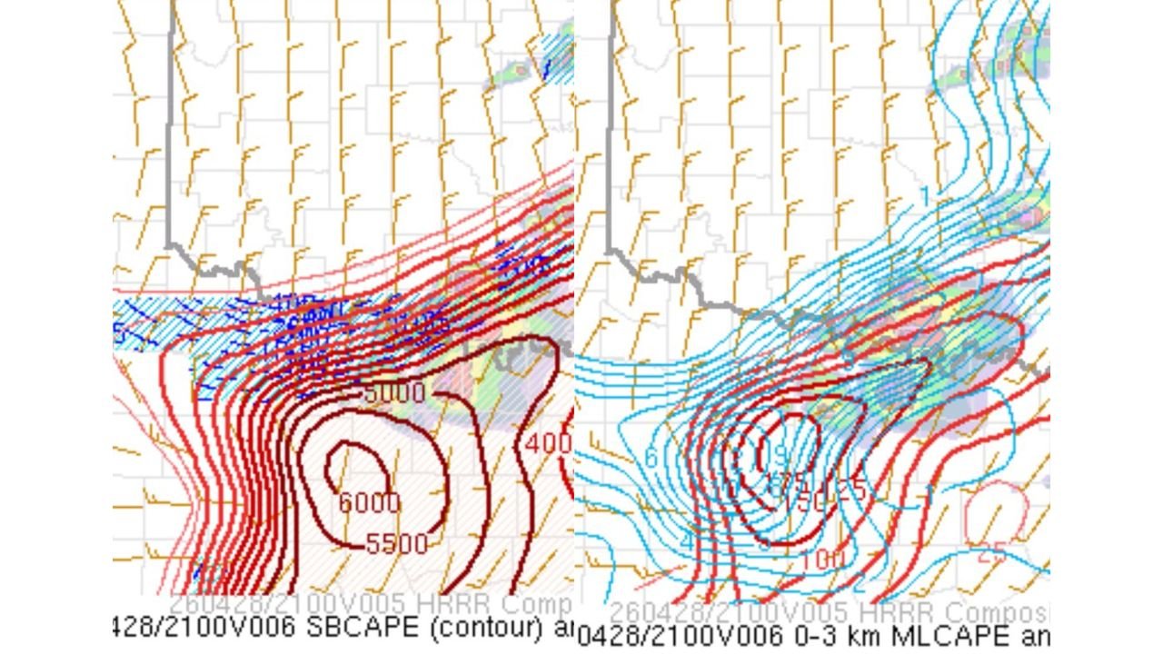
WICHITA FALLS, TX — The atmosphere near Wichita Falls, Texas has reached a level of instability that is extraordinarily difficult to ignore. Current mesoanalysis data valid Tuesday, April 28, 2026 is showing surface-based CAPE values — the explosive atmospheric fuel available to thunderstorms — surging to between 5,000 and 6,000 joules per kilogram across north-central Texas near the triple point, a location where a cold front, warm front, and dry line all converge simultaneously. That convergence zone is one of the most reliable and dangerous storm initiation points in all of severe weather meteorology, and today it is sitting directly over Wichita Falls.
Storm chasers are already moving toward this target. The data demands it.
What the Instability Data Is Showing
Current SBCAPE — Surface-Based Convective Available Potential Energy, measuring the energy available to storms drawing from the lowest layers of the atmosphere — is contoured at 5,000 to 6,000 J/kg in a tightly wound bull’s-eye centered over north-central Texas. The innermost contour on current mesoanalysis reaching 6,000 J/kg places this environment among the most explosively unstable setups observed anywhere in the United States this spring season. Values above 3,500 J/kg are considered extreme. What is being observed here is nearly double that threshold.
The 0 to 3 kilometer Mixed-Layer CAPE — a measurement of instability specifically in the lowest three kilometers of the atmosphere, the layer most critical for tornado intensity — is showing a similarly alarming signal. Contour values on current analysis are wrapping tightly in concentric circles near Wichita Falls, with the innermost rings reaching values in the 750 to over 1,000 J/kg range in the lowest three kilometers alone. High low-level CAPE of this magnitude is directly associated with tornado longevity, intensity, and the potential for violent tornado development. When a storm can draw this much energy from just the lowest layer of the atmosphere, its ability to sustain and intensify a tornado is dramatically enhanced.
The Triple Point and Why It Is the Day’s Most Dangerous Location
The triple point — where three distinct atmospheric boundaries intersect — near Wichita Falls is the focal location for storm initiation this afternoon. A dry line pushing eastward from West Texas, a cold front dropping southward, and a warm front running eastward all meet near this location. Triple points are particularly dangerous storm initiation zones because they concentrate wind shear, moisture convergence, and atmospheric lift into a single geographic point. Storms that develop at or near a triple point have immediate access to the most favorable combination of ingredients in the environment and can intensify into violent supercells within minutes of development.
Any storm that fires at the Wichita Falls triple point this afternoon will be moving into an atmospheric environment loaded with 6,000 J/kg of SBCAPE and exceptional low-level wind shear. The tornado potential for storms developing here is among the highest observed anywhere in the country today.
The Moderate Risk and Dallas-Fort Worth
A Moderate Risk — Level 4 of 5 has been issued and is now specifically driven by a hail-dominant threat pushing into the Dallas-Fort Worth metropolitan area this evening. Giant hail — stones reaching 2 inches or larger — is the primary hazard driving the Moderate Risk designation for the DFW corridor, though the tornado threat is also real and present for the broader north Texas region.
Dallas-Fort Worth is one of the most densely populated metropolitan areas in the United States, with a population exceeding 7 million people across the metro. A hail-driven Moderate Risk over this corridor means the Storm Prediction Center has high confidence that very large to giant hail will impact a significant urban area this evening. Vehicle damage, broken skylights, destroyed roofing, and power outages from hail-snapped trees and lines are all realistic outcomes for the DFW metro as storms move in from the northwest.
Key Data Summary Table
| Parameter | Value | Location | Significance |
|---|---|---|---|
| Peak SBCAPE | 5,500 to 6,000 J/kg | Near Wichita Falls, TX | Extraordinarily explosive atmosphere |
| 0-3km MLCAPE | 750 to 1,000+ J/kg | Triple point zone | Violent tornado potential |
| Storm Initiation Zone | Triple point | Wichita Falls corridor | Most dangerous initiation location today |
| Primary Hail Threat | Very large to giant | DFW metro and north TX | Moderate Risk hail-driven for DFW |
| Overall Risk Level | Moderate — Level 4 of 5 | North Texas corridor | Issued for DFW evening storm arrival |
| Tornado Concern | Significant | Wichita Falls south toward DFW | Concerning environment near triple point |
Area Impact Outlook
Wichita Falls, Texas — Ground zero for storm initiation this afternoon. The triple point location combined with 6,000 J/kg SBCAPE and extreme low-level instability makes this the highest-risk initiation zone in the country today. Tornado-warned supercells are expected to develop here. Residents should be sheltered and monitoring warnings actively through the afternoon.
North Texas corridor (Wichita Falls to DFW) — The storm track from the triple point will carry developing supercells southward and southeastward toward the Dallas-Fort Worth metro through the afternoon and early evening. Every community along this corridor faces exposure to tornadoes, giant hail, and damaging winds.
Dallas-Fort Worth metro — The Moderate Risk is hail-driven for this area with storms expected to arrive during the evening hours. Very large to giant hail is the primary threat. Tornadoes cannot be ruled out. Move vehicles indoors now. The DFW metro has millions of exposed vehicles and structures that are highly vulnerable to a giant hail event.
Denton, McKinney, Arlington, Fort Worth — All within the Moderate Risk zone. Evening severe weather timing means storms will arrive as many residents are commuting or finishing their day. Do not be caught outside or driving when these storms arrive.
Forecast Confidence
Confidence in significant severe weather including tornadoes and giant hail across north-central Texas from Wichita Falls southward toward Dallas-Fort Worth this afternoon and evening is HIGH. The instability values being observed right now are among the highest of the entire spring season. The triple point initiation zone is well-defined. Confidence in giant hail impacting the DFW metro this evening is HIGH. Confidence in significant tornadoes developing near the Wichita Falls triple point is MODERATE to HIGH given the extreme low-level CAPE and favorable wind shear environment.
If you are in north Texas today, your severe weather plan needs to be active right now — not when the sirens go off.
More severe weather coverage is always on the horizon. Stay informed at ChicagoMusicGuide.com — your source for live storm initiation tracking, tornado and hail coverage, and breaking severe weather alerts across Texas and the entire United States.