Rotating Thunderstorm Tracks Toward Daytona Beach Florida With Funnel Cloud Possible and Tornado Warning in Effect Through Early Evening
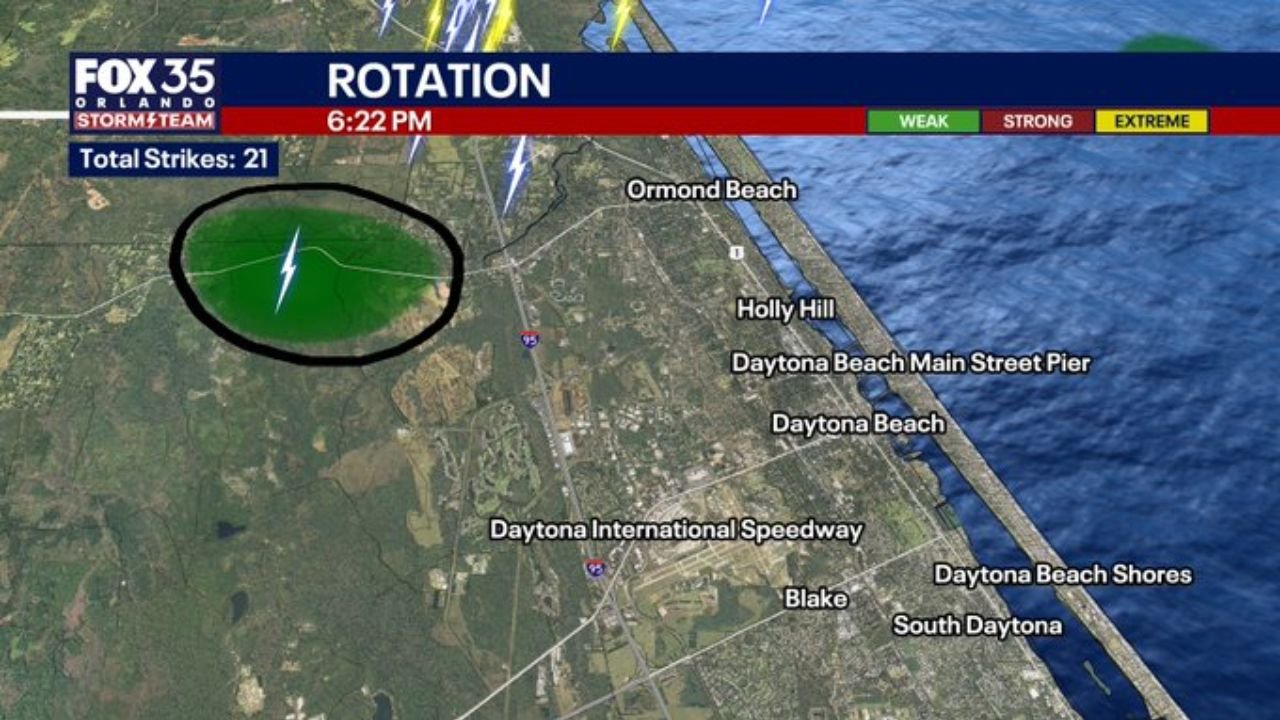
DAYTONA BEACH, FL — A sea-breeze thunderstorm riding along the Florida coast is showing weak but confirmed rotation on Doppler radar as it tracks southeast directly toward Daytona Beach Thursday evening. Current radar analysis captured at 6:22 to 6:23 PM shows the storm approaching Ormond Beach and Holly Hill with a rotation signature identified west of the coastline, and a tornado warning polygon covering the Daytona Beach corridor through the early evening hours.
The storm is moving quickly. Impact timing for key landmarks has already been calculated — One Daytona at 6:32 PM, Daytona International Speedway at 6:33 PM, Daytona Beach International Airport and Embry-Riddle Aeronautical University at 6:34 PM, Daytona Beach proper at 6:35 PM, and South Daytona at 6:39 PM.
What Radar Is Showing
Doppler radar at 6:22 PM is displaying a rotation signature — circled on current analysis — located west of Ormond Beach, inland from the coastline and tracking southeast toward the populated beachside communities. The rotation is classified as weak on current analysis, but it is present and being actively monitored.
The storm tracker radar at 6:23 PM shows a tornado warning box — the dark red polygon — draped over Daytona Beach, Holly Hill, Daytona International Speedway, and extending toward New Smyrna Beach to the south. The storm’s radar presentation shows a tight core of heavy precipitation with 21 total lightning strikes recorded, consistent with an active and electrically charged convective cell riding the sea breeze boundary inland from the Atlantic.
A funnel cloud — the visible rotating column of air extending downward from the storm base that precedes a tornado touching the ground — is possible within the next hour as the storm moves into the Daytona Beach area. A brief tornado cannot be ruled out, though current analysis keeps that probability low given the weak nature of the rotation observed.
Small hail is also possible with this storm.
Sea Breeze Storms and Why They Produce Rotation
Florida’s sea breeze — the daily onshore wind flow generated when cooler Atlantic Ocean air pushes inland against the heated land surface — acts as a low-level boundary that focuses storm development and can enhance rotation in thunderstorms that ride along it. When a thunderstorm tracks along a sea breeze boundary rather than crossing it, the wind shear generated at the boundary interface can tighten the storm’s rotation and increase tornado potential even in relatively weak convective environments.
Today’s storm is doing exactly that — riding the sea breeze boundary southeastward along the Volusia County coastline, keeping it in contact with the rotation-enhancing interface as it approaches Daytona Beach.
Impact Timeline for Daytona Beach Area
| Location | Estimated Impact Time |
|---|---|
| One Daytona | 6:32 PM |
| Daytona International Speedway | 6:33 PM |
| Daytona Beach International Airport | 6:34 PM |
| Embry-Riddle Aeronautical University | 6:34 PM |
| Daytona Beach | 6:35 PM |
| South Daytona | 6:39 PM |
What Residents Should Do Right Now
Anyone in Daytona Beach, Holly Hill, Ormond Beach, and South Daytona should move indoors immediately and away from windows. A tornado warning is in effect, meaning conditions are favorable for a tornado to develop or one has been detected. Even if a tornado does not touch down, the storm will bring heavy rain, frequent lightning, gusty winds, and small hail to the area within minutes.
Beach visitors, outdoor diners, and anyone along the Daytona Beach boardwalk or Main Street Pier area need to seek sturdy shelter indoors now. A rotating thunderstorm approaching from the northwest is not a storm to watch from outside.
Forecast Confidence
Confidence in the storm impacting Daytona Beach and surrounding communities during the 6:32 to 6:39 PM window is VERY HIGH — the storm track is well-defined and moving at a consistent speed. Confidence in a brief tornado is LOW but non-zero given the weak rotation currently observed. Confidence in funnel cloud development is MODERATE as the storm maintains contact with the sea breeze boundary. Confidence in small hail, heavy rain, and frequent lightning across the Daytona Beach corridor is HIGH.
This situation will resolve quickly as the storm moves through. But the next several minutes demand immediate action from everyone in the warning zone.
More severe weather coverage is always on the horizon. Stay informed at ChicagoMusicGuide.com — your source for live storm tracking, tornado warning coverage, and breaking weather alerts across Florida and the entire United States.