Upcoming Cold Snap Across the Northeast Is Right on Schedule With Historical Last Frost Dates Showing No Cause for Alarm
NEW YORK, NY — A colder stretch is on the way for the Northeast United States, and while the drop in temperatures may feel jarring after recent warmth, current climatological data puts this cold foray firmly within normal and expected parameters for this time of year. Last frost date analysis for the region shows that early May frosts are entirely typical across much of the Northeast, late May frosts are historically normal across interior New England and elevated terrain, and June frosts remain a realistic expectation for the highest elevations and northernmost communities in the region.
This is not an unusual or alarming cold event. This is spring in the Northeast behaving exactly as it historically does.
What Last Frost Climatology Shows
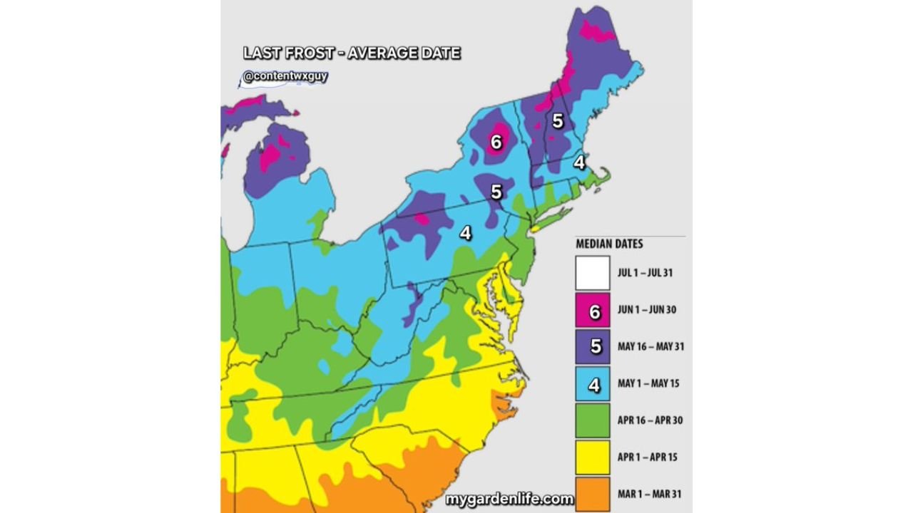
The Last Frost Average Date map covering the eastern United States provides critical context for interpreting any cold event that occurs before summer arrives. The map breaks the region into median frost date zones using a color-coded system that represents when the final killing frost of the season historically occurs at each location.
Across the mid-Atlantic states — including much of Pennsylvania, New Jersey, New York’s lower Hudson Valley, and southern New England — the median last frost date falls in the May 1 through May 15 window, shown in light blue and marked with the number 4 on the map. This means that statistically, half of all years in these locations see a frost occurring after May 1. A cold snap capable of producing frost during the first two weeks of May across Philadelphia, New York City’s surrounding suburbs, Connecticut, and Rhode Island is not an extreme event — it is climatologically average.
Moving into interior New England — covering much of Vermont, New Hampshire, Massachusetts hill country, and upstate New York — the median last frost date extends into the May 16 through May 31 window, shown in purple and marked with 5. Late May frost across these areas is the historical norm, not the exception. Gardeners and farmers across this zone routinely plan around the possibility of frost through Memorial Day weekend.
The most extreme frost climatology in the contiguous Northeast is found across northern Maine, the Adirondacks of New York, the White Mountains of New Hampshire, and other elevated interior zones, where the median last frost date extends into June 1 through June 30 — shown in magenta and marked with 6. June frosts at elevation and in the far north are historically routine occurrences for these communities.
Putting the Current Cold Snap in Context
Current analysis confirms that the incoming cold foray sits well within the tolerance ranges shown in the historical frost date climatology. Early May cold capable of producing frost across the mid-Atlantic falls squarely within the light blue May 1 through May 15 zone that covers most of the populated Northeast. Late May cold affecting interior New England aligns with the purple May 16 through May 31 historical window for that region. And any June cold affecting the highest terrain and northernmost communities in Maine and the Adirondacks is consistent with the June frost climatology documented for those specific zones.
There is no meteorological basis for treating this cold pattern as anomalous or out of season for the Northeast. The region sits at a latitude and elevation range where late spring cold is an expected seasonal feature, not a climate aberration.
Last Frost Zone Reference Table
| Zone Number | Median Last Frost Date | Color | Key Areas |
|---|---|---|---|
| 4 | May 1 to May 15 | Light Blue | NYC suburbs, Philadelphia PA, southern New England, Long Island |
| 5 | May 16 to May 31 | Purple | Interior New England, upstate NY, Vermont, NH hills |
| 6 | June 1 to June 30 | Magenta | Northern Maine, Adirondacks NY, White Mountains NH |
| Apr 16 to Apr 30 | Late April | Green | Mid-Atlantic coast, DC corridor, coastal areas |
| Apr 1 to Apr 15 | Early April | Yellow | Southeast fringe of the region |
What This Means for Residents and Gardeners
For Northeast residents planning gardens or managing outdoor plants, the historical last frost data provides a clear and practical guide. Anyone in the light blue zone — which covers the vast majority of the densely populated Northeast including the New York, Boston, and Philadelphia metro areas — should not have tender plants in the ground unprotected before mid-May. The climatology supports that frost remains a real possibility through that window.
For those in Vermont, New Hampshire, interior Massachusetts, and upstate New York in the purple zone, late May cold protection for sensitive plants is standard seasonal practice, not an overreaction to an unusual event. And for those in northern Maine and at elevation in the Adirondacks and White Mountains, June frosts are simply part of the local climate calendar.
Forecast Confidence
Confidence that the incoming cold snap falls within historically normal parameters for the Northeast in early to mid-May is HIGH. The climatological data is well-established across decades of observation. Confidence in the specific temperature impacts of the upcoming cold event will sharpen as the event draws closer in the forecast window. The key message from current analysis is clear — cold in the Northeast this time of year is expected, documented, and entirely within normal seasonal behavior.
Do not let the calendar fool you into thinking May means warmth is guaranteed across the Northeast. The data says otherwise.
More weather coverage is always on the horizon. Stay informed at ChicagoMusicGuide.com — your source for seasonal climate analysis, frost tracking, and breaking weather coverage across the Northeast and the entire United States.