Plains Severe Weather, Northeast Heat and Texas Heavy Rain Headline the National Hazards Outlook for May 15 Through May 19
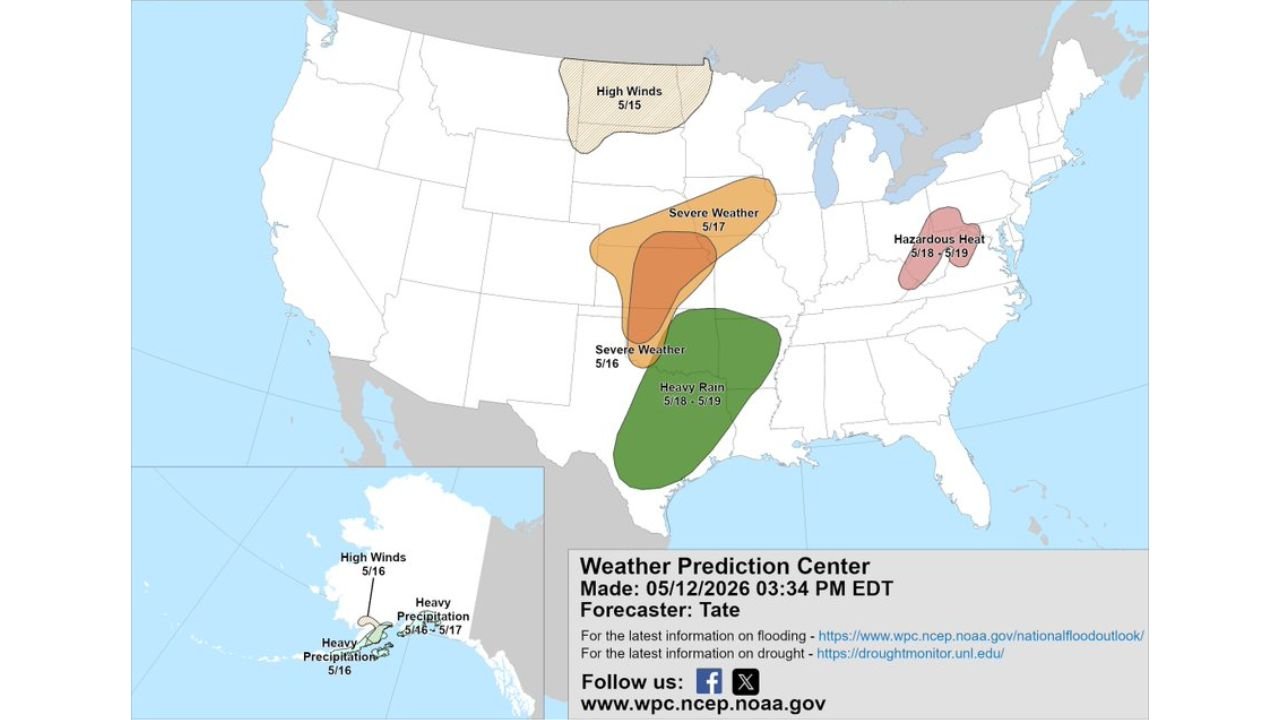
KANSAS CITY, MO — The National Weather Service Weather Prediction Center has issued its Day 3 through 7 Hazards Outlook valid May 15 through May 19, 2026, and four distinct weather hazards are flagged across different regions of the country simultaneously. From high winds in the Northern Plains to hazardous heat in the Northeast to back-to-back severe weather days across the central Plains, this is an active period for a wide stretch of the United States.
High Winds Hit the Northern Plains First on May 15
The week opens with a High Winds hazard flagged across the Northern Plains on May 15, covering portions of North Dakota, South Dakota, and Minnesota. Damaging wind gusts are the primary concern for this event ahead of the approaching storm system.
Severe Weather Targets the Plains on May 16 and May 17
Back-to-back severe weather days are outlined for the central Plains corridor. The May 16 severe weather zone covers a broad area across Kansas, Oklahoma, and adjacent states. The May 17 zone shifts slightly and tightens over a corridor consistent with the long-range tornado signal already flagged in earlier model data this week.
Both days carry the potential for tornadoes, large hail, and damaging winds across the Plains and lower Midwest.
Heavy Rain Soaks Texas and the Gulf Coast May 18 Through 19
A heavy rain threat develops across Texas and the Gulf Coast during May 18 and 19, with flooding potential for communities already dealing with saturated soils from recent rainfall events.
Hazardous Heat Builds Across the Northeast May 18 Through 19
A Hazardous Heat zone is flagged across the Northeast corridor during May 18 and 19, covering portions of the mid-Atlantic and New England states. This early-season heat event will push heat index values well above comfortable levels for a region not yet acclimatized to summer temperatures.
Full Hazards Outlook at a Glance
| Hazard | Dates | Region |
|---|---|---|
| High Winds | May 15 | Northern Plains — ND, SD, MN |
| Severe Weather | May 16 | Kansas, Oklahoma, central Plains |
| Severe Weather | May 17 | Central Plains, lower Midwest |
| Heavy Rain | May 18 to 19 | Texas and Gulf Coast |
| Hazardous Heat | May 18 to 19 | Northeast, mid-Atlantic |
Confidence in the overall hazard placement across all five events is MODERATE. Details on timing, intensity, and exact positioning will sharpen as each event draws closer. Plains residents should treat May 16 and 17 as consecutive severe weather days requiring active monitoring.
More weather coverage is always on the horizon. Stay informed at ChicagoMusicGuide.com — your source for national hazards tracking and breaking weather coverage across the Plains, Northeast, Texas, and the entire United States.