Powerful Mid-Level Vorticity Surge Expected to Sweep Across Indiana as Models Show Intensifying Storm Energy Aloft
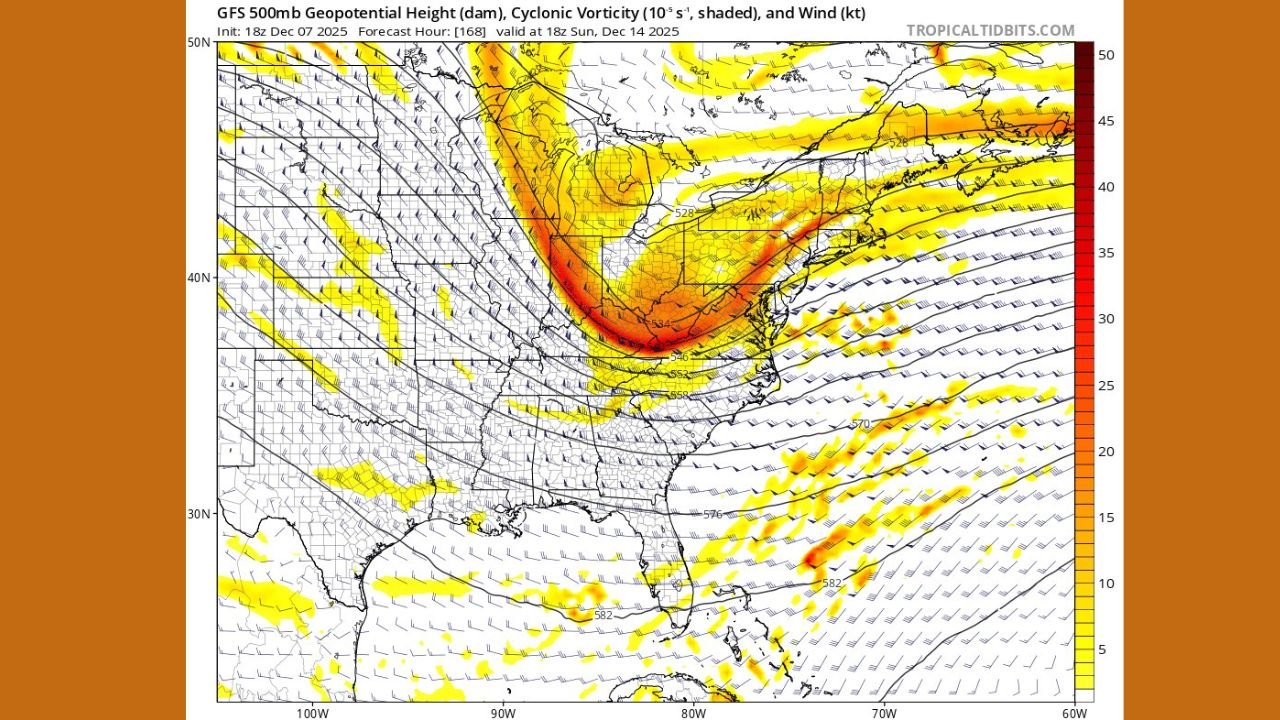
INDIANAPOLIS, IN — A new round of forecast model data is highlighting a potentially disruptive atmospheric setup for Indiana, as a strong surge of mid-level vorticity — the “spin” in the atmosphere that helps drive storm development — is projected to sweep across the Midwest late next week. The latest GFS run shows a pronounced ribbon of enhanced energy diving out of the northern Rockies before sharply amplifying over the Ohio Valley, placing Indiana directly beneath the core of the disturbance.
The meteorological frustration expressed by forecasters in the original model commentary — reacting to a sudden drop in vorticity as the system exits the mountains — underscores the complexity of this pattern and the challenges it poses for predicting impacts at the surface.
A Deepening Trough and Strengthening Jet Energy Over Indiana
Model imagery shows a highly amplified trough carving its way southeast into the central United States. By December 14, the GFS indicates a consolidated band of cyclonic vorticity stretching from the Great Lakes through Indiana and into the Mid-Atlantic, signaling heightened atmospheric instability.
This setup is typically associated with:
- Rapidly developing low-pressure systems
- Strengthened upper-level winds
- A greater likelihood of organized precipitation bands
- Possible snow in colder regions or strong rain bands where temperatures remain above freezing
Indiana sits directly in the corridor where this energy aloft could have the most influence, and the strong gradient between height lines in the graphics suggests enhanced wind fields at the 500mb level — a key driver of storm evolution.
Why the “Vort Drop” Matters for Forecasting
The remark in the original post — “Thank you for dropping the vort as soon as I leave the mountains” — refers to a model quirk in which vorticity often decreases once a storm system exits high terrain. This occurs because the mountains help generate spin in the atmosphere; once the terrain influence is gone, the energy can weaken or shift.
However, in this case, while the initial drop is present, the model quickly re-intensifies the vorticity downstream — and Indiana becomes one of the states positioned beneath that strengthened pocket.
This suggests the potential for:
- Stronger lift in the atmosphere
- More organized storm dynamics
- Possible severe wind gusts depending on surface conditions
- Faster storm system development as the energy consolidates
Potential Impacts for Indiana Residents
While it is still too early for exact predictions, current indicators point toward:
1. Windy Conditions
Upper-level dynamics this strong often translate to gusty surface winds, especially if mixing occurs.
2. Precipitation Development
Indiana could see either rain or snow depending on temperatures during the event. With cold air building over the Midwest recently, snow remains a possibility.
3. Rapid Weather Changes
Highly dynamic systems tend to bring sudden shifts — quick-moving fronts, sharp temperature drops, and fast-arriving precipitation.
4. Travel Impacts
If snow bands develop, even short-duration bursts can create slick conditions on Indiana roadways.
Forecasters Continue Watching for Model Agreement
Meteorologists emphasize that additional runs over the next several days will be crucial. A deeper trough or further consolidation of vorticity could intensify impacts, while a flatter pattern could lessen them.
Still, the current data — especially the strong 500mb signal directly over Indiana — is a notable development for mid-December.
Stay Updated With Chicago Music Guide
Weather plays a major role in live events, travel, and everyday planning. Follow ChicagoMusicGuide.com for ongoing updates as this evolving system approaches the Midwest.