Ohio, Pennsylvania, New York, and Maryland Expected to Face a Major December 23 Winter Storm Bringing Heavy Snow, Icy Mix, and Hazardous Holiday Travel
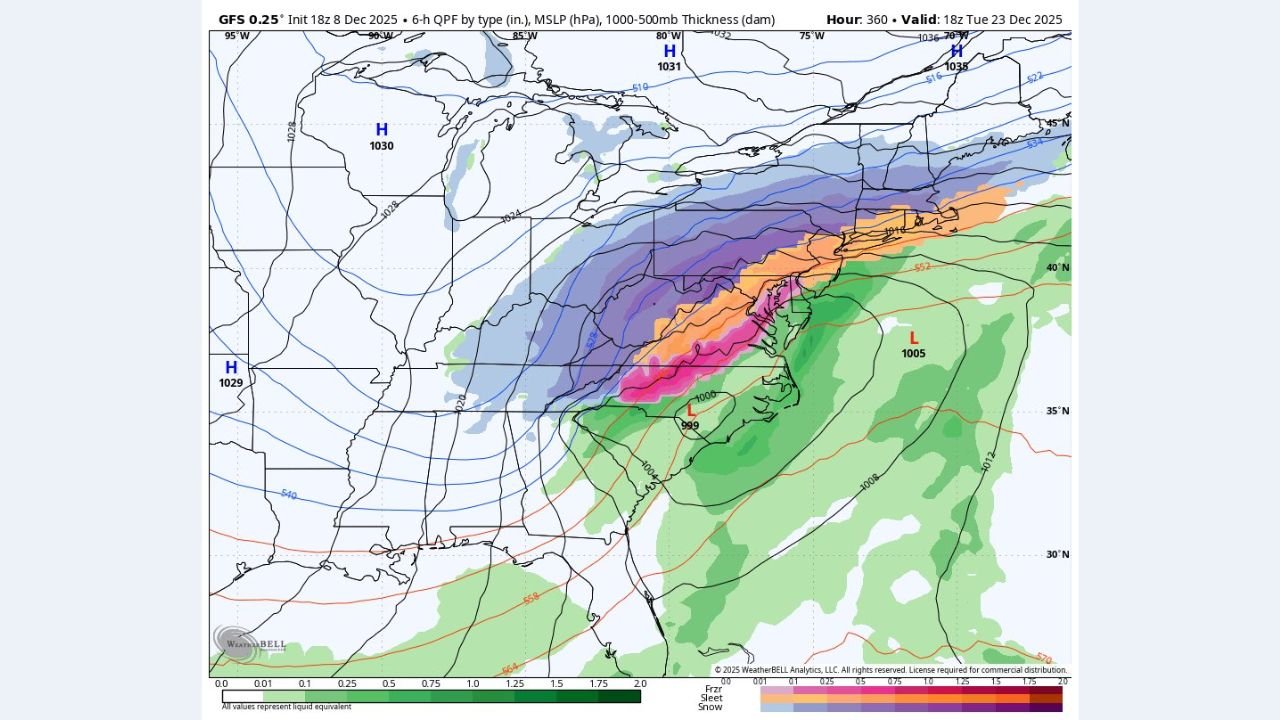
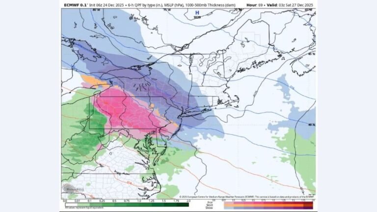
EASTERN U.S. — New Model Data Shows a High-Impact Pre-Christmas Winter Storm Developing Across Several States, A new GFS projection valid for December 23, 2025, shows the early formation of a major winter storm stretching from the Ohio Valley through the Mid-Atlantic and into the Northeast, bringing with it widespread heavy snow, a corridor of mixed precipitation, and potentially hazardous holiday travel conditions.
The storm appears to organize along a central low-pressure center near the mid-Atlantic coast, with a strong surge of moisture interacting with cold air to the north. As a result, states including Ohio, Pennsylvania, New York, Maryland, and West Virginia may experience significant impacts, with the heaviest snow developing along a sharply defined deformation zone shown in shades of blue and purple on the model map.
This system arrives just 48 hours before Christmas, raising the potential for major disruptions to regional travel.
A Classic Winter Storm Structure Taking Shape
The model shows a well-organized storm system featuring:
- A developing low-pressure center near the Carolinas (1005–999 mb)
- A strong high-pressure system over the Great Lakes, funneling cold air into the northern half of the storm
- A wide snow shield covering Ohio, Pennsylvania, West Virginia, New York, and portions of New Jersey
- A narrow zone of sleet and freezing rain over Maryland and parts of Virginia
- A rain-only area farther south into the Carolinas and Tennessee Valley
This setup resembles classic December Appalachian-track systems, which historically deliver heavy snow north of the low, mixed precipitation near the mid-Atlantic, and colder, windier conditions trailing behind the system.
State-by-State Impact Overview
Ohio
- Widespread steady to heavy snow, especially in eastern and northeastern regions
- Potential for 4–10 inches, depending on storm intensity and track
- Travel on I-70 and I-77 may become hazardous
Pennsylvania
- One of the core impact zones
- Model imagery shows heavy snow (purple shading) across central and northern regions
- Southern PA sits closer to the mixing zone, raising concern for ice and sleet
- Expect significant delays along I-80, I-76, and the Pennsylvania Turnpike
New York
- Heavy snow shield extends from western NY through the Finger Lakes and into upstate regions
- Accumulating snow likely impacts travel near Buffalo, Syracuse, and Albany
- Potential for double-digit snow totals in central and upstate NY
Maryland
- Maryland appears at the heart of the storm’s transition zone
- Pink shading indicates sleet and freezing rain, raising the risk of icing
- Western Maryland likely sees snow, while central MD could experience dangerous mixed precipitation
- Commuting and road conditions may worsen rapidly
West Virginia
- Snow likely in the mountains, with mixing possible in the lower elevations
- Travel through mountain passes may become especially treacherous
Timing and Travel Concerns
The storm is projected to intensify on Tuesday, December 23, just as millions prepare for Christmas travel. Key concerns include:
- Rapidly accumulating snow in the northern corridor
- Icy roads in areas experiencing sleet or freezing rain
- Potential flight delays or cancellations in major hubs including Pittsburgh, Cleveland, Philadelphia, and Baltimore
- Reduced visibility under heavy snow bands
With this event occurring so close to Christmas, transportation impacts could be wide-reaching.
Important Notes on Forecast Uncertainty
As with all long-range projections:
- The exact track of the storm remains uncertain
- A shift north or south of even 50 miles could dramatically alter snow and ice placement
- Additional model runs in the days ahead will clarify precipitation amounts and timing
However, the consistency of a strong storm signature suggests that a significant event is increasingly plausible.
What Residents Should Do Now
While details will evolve, residents across Ohio, Pennsylvania, New York, Maryland, and surrounding states should:
- Monitor daily local forecasts
- Prepare for possible pre-holiday travel delays
- Make backup plans for road and air travel
- Stock up on essentials in case of short-term power or road disruptions
Early awareness is crucial given the storm’s timing and regional reach.
Stay connected with ChicagoMusicGuide.com for updated storm forecasts, travel impacts, and detailed coverage as this developing Christmas week system comes into focus.