North Carolina Expected to See Cold Rain for the Piedmont and Light Mountain Snow Monday as Quick-Moving Winter System Arrives
NORTH CAROLINA — A fast-moving winter system is set to sweep across the state Monday, delivering cold rain to the Piedmont and light accumulating snow to the mountains and foothill regions.
Meteorologists warn that while most communities across Charlotte, Gastonia, Concord, Salisbury, Monroe, and Rock Hill will experience a raw, chilly day with temperatures stuck in the 30s and 40s, the North Carolina High Country will face wintry conditions that could make travel hazardous, especially during the morning hours.
Areas including Boone, Banner Elk, Jefferson, Morganton, Taylorsville, Statesville, and parts of northern Greensboro suburbs have been placed under Winter Weather Advisories, with the highest elevations likely to see slick spots as snow accumulates.
The system moves in quickly Monday morning and exits the state by early evening.
Winter Weather Alerts Highlight Risk for the Mountains and Northern Foothills
According to the alert map, several counties along the Blue Ridge and Appalachian chain fall under Winter Weather Advisory status. These regions can expect:
- Periods of steady snow
- Light accumulations creating slippery roads
- Reduced visibility in higher elevations
- Isolated slick spots developing through midday
Communities near Asheville, Boone, Bristol, and Morganton will see the greatest chance for travel disruptions.
Piedmont and Charlotte Metro: Cold, Wet, and Unpleasant Weather Ahead
While snow will be limited to the mountains, the Charlotte region and larger Piedmont corridor will be cold and rainy throughout the day.
Forecast guidance shows widespread light to moderate rain across:
- Charlotte
- Gastonia
- Lincolnton
- Salisbury
- Concord
- Monroe
- Albemarle
- Rock Hill
- Southern Pines
Rainfall should not be especially heavy, but the combination of saturated roads, cold temperatures, and low visibility will make for a dreary start to the week.
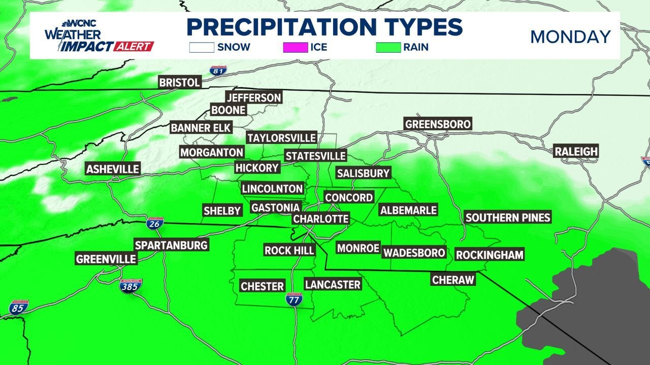
Precipitation Type Breakdown: Snow in the North, Rain for Most of the State
The precipitation-type map shows a clear divide across North Carolina:
- Snow: Western mountains and the northern foothills
- Rain: Charlotte metro, central Piedmont, and the entire southern half of the state
- Ice: Not expected with this system
This setup confirms that higher elevations will bear the brunt of winter impacts, while most of North Carolina sees only cold, unpleasant rain.
Winter Weather Impacts: Mostly Minor, but Use Caution in Higher Elevations
Impact maps indicate:
- Low to minor impacts in mountain counties
- Little to no impact for the Charlotte metro
- Localized travel concerns around Boone, Jefferson, and parts of Ashe County
Drivers in snow-prone regions should prepare for slippery roads, especially during the early morning commute.
Timing: Quick Hit of Winter Weather Before Clearing Out
Meteorologists expect the system to move efficiently through the state:
- Begins: Monday morning
- Peak impacts: Late morning through early afternoon
- Clears out: By early evening
This swift movement limits snowfall totals but still poses travel hazards.
Cold and Wet Conditions Require Extra Care
WCNC’s Weather Impact guidance highlights several safety notes:
- Dress in layers — temperatures will remain in the 30s and low 40s for most areas
- Use caution on wet roadways — standing water and slick spots are possible
- Watch conditions in the mountains — snow-covered roads may develop quickly
The combination of cold air and widespread precipitation will make Monday feel particularly harsh across the state, even in areas not receiving snow.
North Carolina faces a cold, wet, and uncomfortable Monday, with winter weather alerts in effect for mountain and foothill regions. The Charlotte metro and surrounding Piedmont counties will see steady cold rain, while higher elevations experience accumulating snow and slick travel conditions.
Residents traveling into the mountains should use extra caution, check road conditions frequently, and plan for potential delays.
Stay with ChicagoMusicGuide.com for continuing updates, forecasts, and weather alerts affecting your region.