Minnesota, Wisconsin, the Dakotas, and Much of the Midwest Brace for Dangerous Arctic Blast With Temperatures 20–40 Degrees Below Normal Later This Week
UNITED STATES — A powerful surge of Arctic air is set to crash into the northern and central United States late this week, delivering some of the coldest temperatures of the season and wind chills that could plunge well below zero across the Midwest.
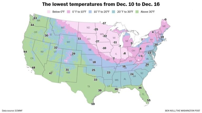
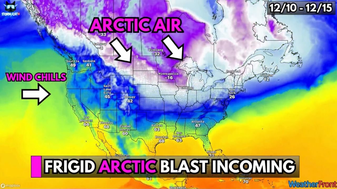
Weather models show a widespread outbreak of frigid Canadian air sweeping south between December 10 and December 15, arriving immediately behind several fast-moving Alberta clipper systems. The pattern will send temperatures tumbling 20 to 40 degrees below average, with the harshest conditions centered over Minnesota, Wisconsin, Iowa, the Dakotas, and northern Illinois.
Forecasters warn that this event could bring near-record cold for early December, particularly in states closest to the Canadian border.
Midwest Expected to Take the Brunt of the Arctic Arrival
Map data shows temperatures in cities like Minneapolis, Fargo, Sioux Falls, and Duluth dropping dramatically, with some locations expected to fall below zero during nighttime hours.
Wind chills could reach:
- –10°F to –20°F across Minnesota and Wisconsin
- –20°F to –30°F across North Dakota and South Dakota
- Single digits to subzero across Iowa and northern Illinois
These extreme wind chills increase the risk of frostbite, especially for anyone spending extended time outdoors.
Alberta Clippers Will Reinforce the Cold Throughout the Week
The incoming Arctic blast does not arrive alone. Multiple Alberta clipper systems—fast, lightweight winter storms originating in western Canada—will drag down additional cold air as they sweep across the country.
As these systems move through:
- The northern U.S. will see frequent bursts of snow, creating slick roads
- Wind speeds will increase, making conditions feel even colder
- Visibility may briefly drop in snow squalls
Clipper-driven cold outbreaks are notorious for producing short-lived but intense weather, and this week’s setup shows several such systems lined up back-to-back.
Temperature Snapshot: Coast-to-Coast Impact
The temperature map reveals a dramatic temperature contrast across the country:
- Seattle, Spokane, and the Pacific Northwest feel the first wave of cold, with wind chills dropping quickly.
- Denver, Salt Lake City, and surrounding Rockies fall into the 30s and 40s with strong northerly winds.
- Dallas, Houston, and southern states remain warmer but still trend downward as Arctic air slides southeast.
- Chicago, Milwaukee, and the Great Lakes region transition rapidly from seasonal temperatures to harsh subzero wind chills.
- New York and the Northeast will feel a moderated version of the cold but still see significant temperature drops.
No region escapes the effects entirely—however, the Midwest faces the worst of the outbreak.
Why Is This Cold so Intense?
Meteorologists point to a combination of atmospheric factors:
- A deep Arctic high-pressure system descending into the U.S.
- Repeated reinforcement from Alberta clipper disturbances
- A strong upper-level jet stream transporting cold rapidly south
This setup finely aligns to deliver a severe cold outbreak that is both abrupt and widespread.
Cold Pattern Expected to Continue Into Early Next Week
Forecasts indicate that this Arctic air mass will not exit quickly. Instead, the pattern favors continued cold through early next week, with additional clipper systems likely to:
- Bring more snow chances
- Strengthen chilly winds
- Prevent temperatures from recovering
Residents across the Midwest should prepare for multiple days of subfreezing conditions.
What Residents Should Do Now
Meteorologists emphasize preparedness:
- Bundle up in layers when outdoors
- Limit time outside during periods of extreme wind chills
- Keep emergency car kits stocked in case of breakdowns
- Check heating systems and insulate exposed pipes
- Bring pets indoors to prevent cold-related injury
This blast is dangerous enough that precautions are strongly recommended for all Midwest residents.
A significant and potentially hazardous Arctic outbreak is set to hit the northern United States later this week, with Minnesota, Wisconsin, Iowa, the Dakotas, and northern Illinois seeing the coldest impacts. Wind chills could reach –30°F, and repeated Alberta clippers will reinforce the bitter conditions.
Winter is arriving with force—and this is only the beginning of what could become an active December pattern.
Stay with ChicagoMusicGuide.com for ongoing coverage, updates, and temperature alerts throughout the week.