Maryland, Pennsylvania, and West Virginia Bracing for Dangerous Wednesday Storm With Blizzard Conditions, High Winds, and Travel Hazards Across the Region
MARYLAND, PENNSYLVANIA & WEST VIRGINIA — A High-Impact Midweek Storm Will Bring Blizzard Conditions, Strong Winds, and Hazardous Travel Across the Region, A significant winter storm is expected to unfold on Wednesday, affecting communities from central Maryland to southern Pennsylvania and into the mountain regions of West Virginia. The system will bring a combination of freezing rain, rain, heavy mountain snow, and dangerously strong winds, creating a fast-changing and potentially hazardous day for millions of residents.
The storm will begin early in the morning with areas of freezing drizzle in northern zones, followed by heavy wind and rain through the afternoon, and full blizzard conditions in the mountains.
Morning: Freezing Rain Threat for Southern Pennsylvania and Northern Maryland
Early Wednesday morning, a narrow band of light freezing rain or freezing drizzle may form between 6 AM and 8 AM across:
- Gettysburg, PA
- York, PA
- Harrisburg, PA
- Areas near Route 15 and Catoctin Ridge
- Northern Maryland near Frederick and Hagerstown
Even a light glaze is enough to cause slick roads, bridges to ice quickly, and sudden hazard zones for the morning commute.
Motorists traveling through these communities should plan for delays, reduced speeds, and rapidly changing road conditions.
Midday: Rain Spreads Into Central Maryland
By early afternoon, warmer air pushes northward, allowing **rain to develop across:
- Baltimore
- Washington, D.C.
- Annapolis
- Frederick
- Westminster
This rain will reduce any lingering ice but will also set the stage for very strong winds as the storm intensifies.
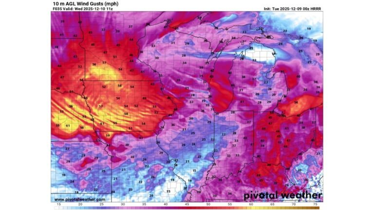
Winds Strengthen Regionwide: 35–50 MPH Gusts
As the storm’s front pushes through, powerful wind gusts will develop across the region:
Expected Peak Gusts
- 35–45 mph across Baltimore, Washington, Lancaster, York, and Philadelphia
- Up to 50 mph in western Maryland, including McHenry and Oakland
- Strong crosswinds on major highways including I-70, I-83, and I-81
These winds may lead to:
- Downed tree limbs
- Difficult driving for high-profile vehicles
- Scattered power outages
- Rapidly dropping visibility in snowy regions
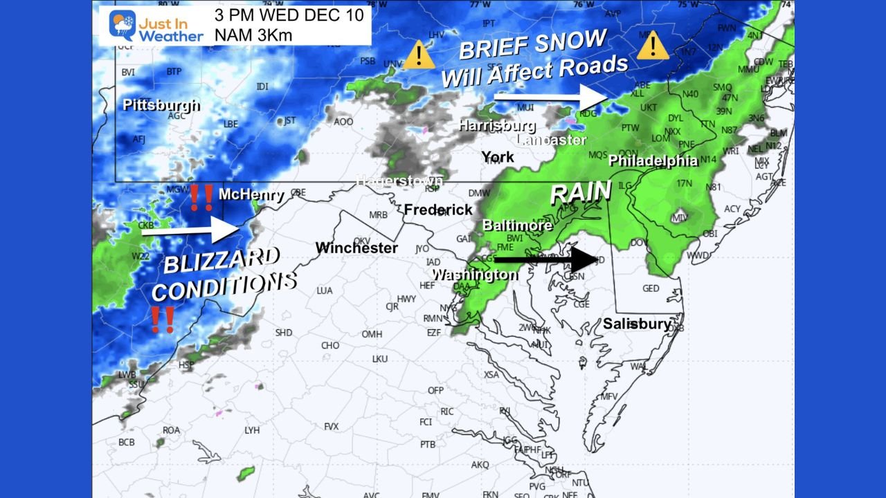
Blizzard Warning Issued for Western Maryland and Canaan Valley
The most dangerous part of this storm will occur in the western mountains of Maryland and parts of northeastern West Virginia.
Blizzard Warning Areas
- McHenry, MD
- Oakland, MD
- Canaan Valley, WV
These areas will experience:
- Wind gusts up to 50 mph
- Snowfall rates of 1 inch per hour or higher
- Whiteout conditions
- Near-zero visibility
- Snow totals of 4–8 inches, with up to 12 inches above 2,500 ft on west-facing slopes
Travel through these elevated areas will become extremely dangerous and may become impossible during the height of the storm.
Afternoon Road Impacts: Snow for Northern Pennsylvania, Rain for Maryland
By mid-afternoon:
- Heavy snow will affect travel across northern Pennsylvania, including areas near Harrisburg, Lancaster, and York
- Rain will continue in Maryland and D.C., with pockets of stronger wind
- The rain-snow line remains sharply defined, causing shifts in travel conditions within short distances
Drivers heading north out of Maryland into Pennsylvania should expect sudden transitions from rain to snow, with accumulating snow likely on untreated roads.
Evening: Winds Continue as Storm Pulls Away
Even after precipitation tapers, strong winds will remain through the evening, particularly in:
- Western Maryland
- Southern Pennsylvania
- Northern Virginia
Wind chills will fall sharply, and blowing snow will continue in the mountains.
What Residents Should Do to Prepare
- Allow extra travel time Wednesday morning and afternoon
- Avoid mountain routes if possible during the blizzard window
- Prepare for potential power outages in high-wind areas
- Use caution on bridges and overpasses where ice forms first
- Keep updated with local advisories as conditions may change quickly
Looking Ahead
The storm will exit Wednesday night, but cold air and lingering wind will remain across parts of the region. Mountain areas may continue experiencing blowing and drifting snow into early Thursday.
ChicagoMusicGuide.com will continue monitoring major regional weather events across the country, including winter hazards, wind impacts, and severe weather risks.