Brutal Arctic Cold Surge Set to Plunge Into Illinois and the Midwest With Temperatures 20–40 Degrees Below Normal
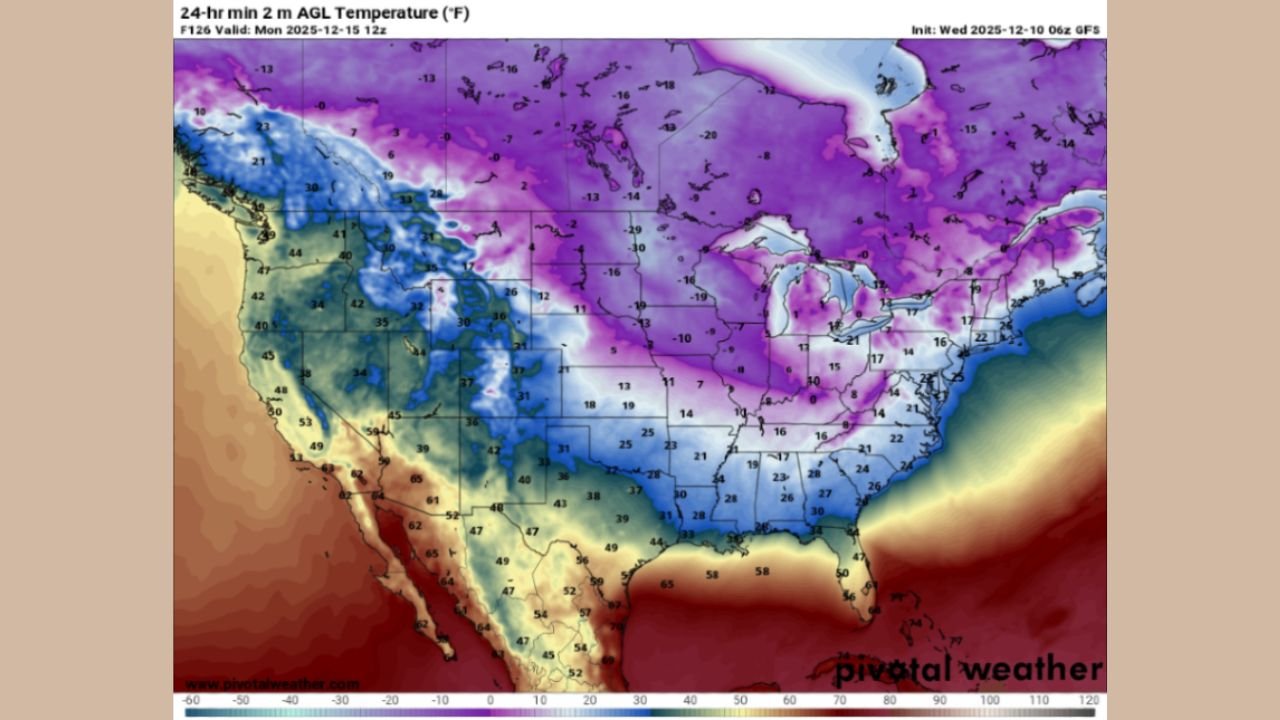
CHICAGO, ILLINOIS — A dangerous blast of Arctic air is poised to sweep into the Midwest, Ohio Valley, and Great Lakes late Sunday into Monday, delivering the coldest temperatures of December and one of the sharpest early-season drops in years. New temperature projections show large portions of the region falling 20 to 40 degrees below normal, with widespread single-digit lows, subzero wind chills, and daytime highs that barely rise above freezing.
A Major Temperature Crash Beginning Sunday Night
High-resolution forecast maps show a deep pool of Arctic air spilling southward out of Alaska and northwest Canada—where current readings have dropped to -40°F to -50°F—before pushing aggressively into the central and eastern United States.
By Sunday night, the core of the cold will settle over:
- Illinois
- Iowa
- Wisconsin
- Michigan
- Indiana
- Ohio
Across this stretch of the country, overnight lows are forecast to drop into the single digits, while northern areas could see readings below zero for the first time this season.
Wind chill values are expected to plunge far lower, creating conditions that forecasters warn could become dangerous for anyone without proper protection.
Forecast Maps Highlight a Widespread, Severe Cold Outbreak
The provided temperature maps show a striking transition:
- Deep purple shading across the Upper Midwest and Great Lakes signals the most extreme cold, with predicted lows from -10°F to -20°F in parts of Minnesota, Wisconsin, and Michigan.
- Illinois and Indiana appear in the center of the outbreak, holding steady in the 0°F to 10°F range by Monday morning.
- Subzero wind chills will stretch from Chicago through Detroit, Cleveland, and into western Pennsylvania.
- Even cities as far south as Memphis, Atlanta, and Dallas will feel temperatures well below normal.
Forecasters note that while winter officially begins later in the month, these temperatures are more typical of mid-January than mid-December.
Why This Surge Is Different From Earlier December Cold Shots
Unlike previous brief cool-downs, this Arctic blast features:
- A direct pipeline of polar air from northwest Canada
- Fast southward movement, reaching the central U.S. in a matter of days
- Large-scale cold coverage, affecting nearly two-thirds of the nation
- A wide region of 40-degree departures from normal, which is unusually large for mid-December
The magnitude of the cold pool and the steep temperature gradient suggest that conditions could be harsh enough to strain infrastructure, increase energy demand, and elevate risks for frostbite during peak wind chill periods.
Impacts for Illinois and the Surrounding Region
Residents across Illinois—particularly northern counties—should prepare for:
- Single-digit lows and possible subzero readings
- Wind chills between -10°F and -25°F
- Very cold daytime highs on Monday, potentially not reaching 15°F in parts of the state
- Hazardous early-morning commutes due to icy patches and bitter wind chills
Chicago is expected to be one of the hardest-hit urban areas as the core of the cold rotates southeastward.
Forecasters also note that snow cover in the Upper Midwest could enhance cooling in nearby regions, making the cold even more intense in localized pockets.
How Long Will the Cold Last?
Based on current projections, the coldest window appears to stretch from Sunday night to late Monday, with some moderation possible by midweek. However, long-range signals suggest the broader pattern remains capable of additional cold intrusions as December progresses.
Winter may not be officially underway, but the atmosphere is already behaving like deep January.
Stay Prepared and Stay Informed
How are you getting ready for this dangerous early-season Arctic blast? Share your thoughts, cold-weather tips, or local conditions with us — and follow ChicagoMusicGuide.com for continued updates as this surge unfolds.