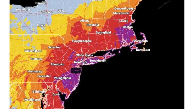
Maryland, Delaware, New Jersey, and Massachusetts to See Quick-Hitting Snow Band Sunday as Arctic Front Races From Washington D.C. to Boston
WASHINGTON, D.C. — Fast-Moving Arctic Front to Sweep Down East Coast With Burst of Snow, A sharp arctic front is expected to race across the East Coast on Sunday, bringing a quick but impactful burst of snow from Washington D.C. to Boston. Forecasters say the strongest impacts are likely along the urban and coastal corridor, including parts of Maryland, Delaware, New Jersey, and Massachusetts, where a couple of inches of snow may fall in just a short window of time.
This is not a full-blown winter storm, but the combination of rapidly falling temperatures and a narrow band of snow behind the front could still create slippery roads and reduced visibility for several major population centers.
Arctic Air Charges South Behind Developing Front
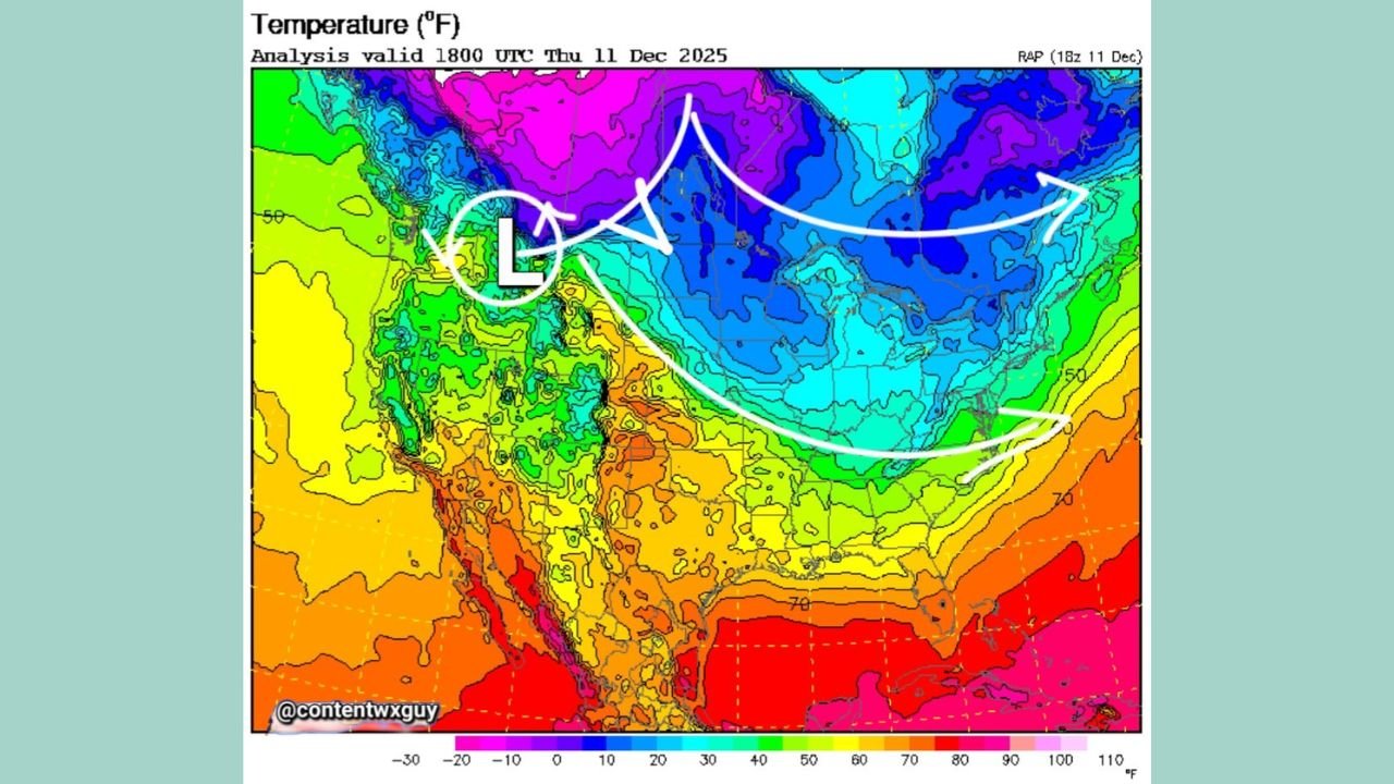
The temperature map shows bitterly cold air pooling over western Canada and the northern Plains, with readings far below freezing. By Sunday, that air mass surges southeast, marked on the map by a sweeping arc of colder colors pushing toward the Great Lakes and then the East Coast.
As the front dives toward the Mid-Atlantic and New England:
- Much colder air spills in behind it
- Mild pre-frontal air along the I-95 corridor is quickly replaced
- An area of low pressure forms along the boundary, helping to focus a swath of snow
The setup favors a fast change from relatively mild to sharply colder conditions as the front passes.
Quick Burst of Snow From D.C. to Boston
The main concern is a short-lived band of snow developing behind the front, known as an anafrontal snow band. This feature can briefly intensify snowfall rates even though the overall system is not large.
From D.C. through Baltimore, Philadelphia, New York City, Providence, and Boston, the corridor could see:
- A quick burst of snow as the front moves through
- Accumulations on the order of a couple of inches in spots, especially on grassy and untreated surfaces
- Localized slick spots on roads, ramps, and bridges
Because the front is moving quickly, the snow won’t last long in any one location, but it may arrive during busy travel times.
Not a Nor’easter, But Still an Impactful Event
Unlike a classic coastal storm that lingers for many hours, this setup is compact and fast-moving:
- No large, slow-moving coastal low is expected
- Strong winds and heavy, long-duration snow are not the main story
- The key impact is the sudden change in conditions — from dry roads to snow-covered surfaces and falling temperatures
Even without major storm status, the front can still catch drivers and pedestrians off guard if they are not prepared for the rapid shift.
What Residents in Maryland, Delaware, New Jersey, and Massachusetts Should Expect
As the front pushes east on Sunday, residents should be ready for:
- Clouds thickening, followed by a brief period of snow behind the front
- Temperatures dropping quickly once winds shift to a colder direction
- Roads going from merely wet to slick in a short time, especially on secondary streets
- Visibility reductions during the heaviest snow bursts
Along the coast and in urban centers, the exact totals will depend on how quickly the ground cools and how intense the snow band becomes, but light to locally moderate accumulations are on the table.
Travel and Event Impacts Along the I-95 Corridor
The Washington D.C.–Boston corridor is one of the busiest stretches of highway and rail in the country. Even a modest winter event can cause issues when it lines up with weekend plans.
Potential impacts include:
- Slower highway travel and possible minor spinouts where snow sticks quickly
- Delays for buses and commuter rail lines
- Difficult walking conditions on untreated sidewalks and station platforms
- Last-minute changes to concerts, holiday markets, and outdoor events scheduled for Sunday afternoon and evening
Planning extra travel time and checking local updates before heading out will be important for anyone moving between cities along I-95.
Stay Tuned With ChicagoMusicGuide.com
ChicagoMusicGuide.com will continue to follow this arctic front as it approaches the East Coast, keeping an eye on timing, snow amounts, and how conditions may affect travel plans, live shows, and holiday events.
For musicians on the road, crews hauling gear, or fans heading to venues from D.C. to Boston, check back for more weather updates and practical guidance to help you stay safe on the way to the music.