Ohio Braces for Significant Winter Storm as Models Highlight High Snowfall Probabilities Across Southeast Region
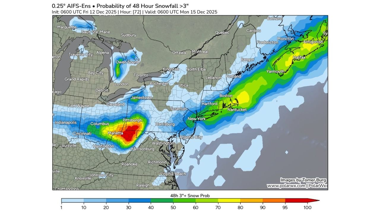
OHIO — New Model Data Highlights a Strong Winter Storm Signal, A developing winter system expected late this weekend is now showing increasingly strong agreement across multiple forecast models, with both the AIFS and EPS ensembles pointing toward southeast Ohio as one of the most heavily impacted areas in the entire Midwest-to-East Coast corridor.
The latest graphics show a tightly focused band of high snowfall probability building over the region, signaling a likely disruptive winter event from late Saturday night through early Monday morning.
Forecast Models Align on a High-Impact Zone in Southeast Ohio
While the AIFS and EPS remain divided over snowfall placement along the East Coast, Ohio stands out as a region where the two models strongly agree.
Key takeaways from the ensemble data:
- A red and orange core of high probability (approaching 90–100%) is centered over Marietta and parts of southeastern Ohio.
- Snowfall probabilities remain solid across Columbus, Pittsburgh’s western outskirts, and surrounding counties.
- The consistency across both model suites increases confidence in meaningful snow accumulation, especially for the southeastern part of the state.
This agreement is notable because the same models show large differences regarding snowfall potential in New York, New Jersey, and coastal New England.
Timing: Snow Arrives Late Weekend and Continues Into Monday
The strongest window for accumulating snow appears to be:
- Saturday night through early Monday morning
- Valid through 0600 UTC Monday, December 15, 2025
During this period, cold air in place over the northern U.S. is expected to interact with a developing system sweeping eastward, creating the setup for steady snow across Ohio.
Which Parts of Ohio Will See the Greatest Impact?
Southeast Ohio — Highest Impact
- Marietta region highlighted with the strongest snowfall probabilities
- High likelihood of 3+ inches, potentially more depending on storm evolution
Central Ohio — Moderate Impact
- Columbus region sits within a broader band of accumulating snow
- Totals uncertain but accumulation is likely
Northern Ohio — Lower Impact
- Cleveland and Toledo appear on the fringe zones
- Light accumulation possible
What This Means for Travel and Daily Plans
With confidence rising in the model agreement, southeast Ohio residents should prepare for:
- Potential travel disruptions
- Reduced visibility during peak snowfall
- Early-week impacts for commuters and students
Even though totals may vary outside the southeastern core, the state as a whole should remain alert to updated forecasts as the storm approaches.
Stay Tuned for More Regional Weather Coverage
ChicagoMusicGuide.com will continue providing updates on major winter systems affecting the Midwest and nearby regions. As the models tighten their track in the next 24–36 hours, snowfall projections for Ohio may become even more refined.