Illinois, Indiana, Kentucky, and Ohio Brace for Record-Breaking Cold Monday as Temperatures Plunge Into Single Digits
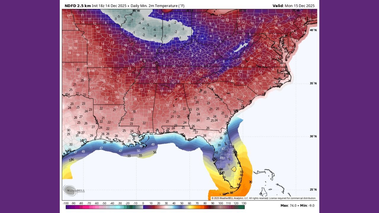
ILLINOIS — A powerful surge of Arctic air is set to deliver one of the coldest mornings of the season on Monday, bringing widespread single-digit lows and record-challenging temperatures across Illinois, Indiana, Kentucky, and Ohio. Forecast maps show that the core of the cold settles directly over the Midwest and Ohio Valley, driving temperatures far below mid-December norms.
Record-Breaking Cold Expected Across the Midwest and Ohio Valley
The National Digital Forecast Database (NDFD) indicates that large portions of the region will experience temperatures in the 3°F to 12°F range, with wind chills dropping even lower during the early morning hours.
Illinois: Widespread Single Digits and Record Threats
Forecast lows across Illinois fall sharply overnight, with:
- Northern Illinois: 3°F to 8°F
- Central Illinois: 8°F to 12°F
- Chicago metro: 6°F to 10°F
These values fall into territory that could challenge existing daily records for December 15. Clear skies and deep snowpack in some areas may intensify the cold further.
Indiana: Coldest Morning of the Month
Indiana is positioned squarely in the path of the coldest air. Forecast models show:
- Northern Indiana: 4°F to 10°F
- Central Indiana (including Indianapolis): 10°F to 14°F
- Southern Indiana: Mid to upper teens
The rapid freeze following recent precipitation may also create slick travel conditions Monday morning.
Kentucky: Significant Temperature Drop Overnight
While Kentucky sits slightly south of the core Arctic influence, the state still faces its coldest morning so far this winter season.
- Northern Kentucky: 12°F to 16°F
- Central Kentucky: 16°F to 20°F
- Western Kentucky: 18°F to 22°F
Many locations will run 15 to 20 degrees below normal for mid-December.
Ohio: Bitter Early Morning Cold Across the State
Ohio joins the deep freeze as temperatures fall sharply statewide.
- Northwest & Central Ohio: 6°F to 12°F
- Columbus region: Near 10°F
- Southern Ohio: 12°F to 18°F
Areas with snow cover will see the cold intensify further before sunrise.
Why the Cold Is So Extreme
Meteorologists attribute this bitter cold to:
- A strong high-pressure system centered over the Midwest
- Clear skies promoting overnight radiational cooling
- Fresh snow in several regions enhancing heat loss
- A direct north-to-south wind channel pulling Arctic air into the Ohio Valley
This combination sets up ideal conditions for record-breaking lows across multiple states.
What Residents Should Expect Monday Morning
Residents across Illinois, Indiana, Kentucky, and Ohio should plan for:
- Hazardously cold morning temperatures
- Wind chills well below zero in localized areas
- Icy roads where moisture refreezes overnight
- Increased heating demand during early morning hours
Schools, commuters, and morning travelers should be prepared for a notably cold start to the week.
Stay Updated
Keep checking ChicagoMusicGuide.com for ongoing weather coverage, forecast updates, and safety information as this Arctic air mass moves through the region.