Minnesota, Wisconsin, Iowa, and Illinois Face Another Arctic Blast Thursday With Subzero Air Moving South
MINNESOTA — A new surge of arctic air is expected to sweep into the Upper Midwest on Thursday, bringing another round of dangerously cold temperatures across Minnesota, Wisconsin, Iowa, and Illinois. While this incoming system is not projected to be as severe as the recent weekend arctic blast, forecasters warn that subzero temperatures and pockets of heavy snow remain possible.
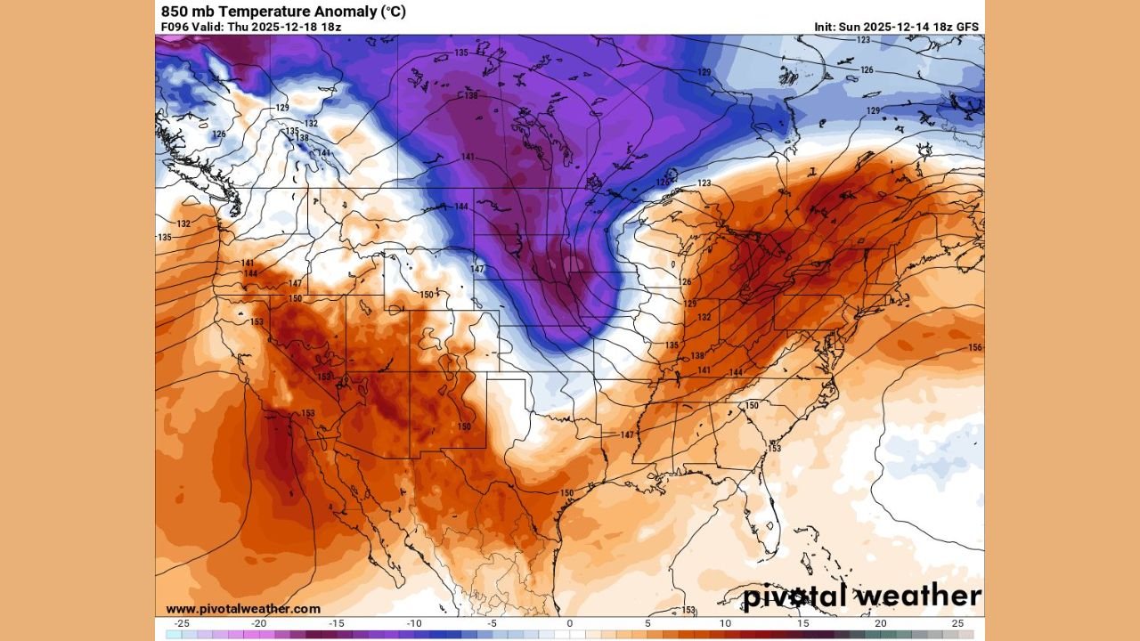
Deep Cold Expands Across the Upper Midwest
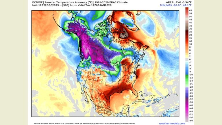
Forecast data shows a broad pool of extremely cold air dropping south from Canada, concentrating heavily across Minnesota and Wisconsin, where the temperature anomalies are the most significant. The 850mb temperature map indicates a strong core of below-normal temperatures positioned over the northern tier of the region, signaling another round of bitter conditions.
This expansive cold dome will continue sliding southeast into Iowa and northern Illinois, where residents can expect a sharp drop in temperatures heading into Thursday afternoon and evening.
Subzero Temperatures Possible Again
Although forecasters emphasize that this outbreak will not match the intensity of the previous blast, the projected cold remains notable:
- Minnesota may experience widespread subzero temperatures once again.
- Wisconsin is expected to fall well below freezing, especially in the central and northern counties.
- Iowa could see single-digit lows, with wind chills pushing below zero.
- Illinois may feel the southern extent of the cold, with northern counties at highest risk for the most significant temperature drops.
The steep temperature gradient shown in the forecast map highlights how quickly this air mass will overtake the region.
Heavy Snow Potential and Storm Risks
The incoming system carries the potential to produce heavy snow, especially along the cold front as it moves east and south. Elevated snowfall rates may become an issue in parts of:
- Eastern Iowa
- Southern Wisconsin
- Northern Illinois
Forecasters are also monitoring the possibility of strong to severe storms returning to the Ohio Valley, though the primary focus for this article remains on the core impact states of Minnesota, Wisconsin, Iowa, and Illinois.
Why This Arctic Push Matters
This is the second major cold blast in less than a week, arriving on the heels of a weekend system that drove temperatures to extreme lows. Even if the new outbreak is less severe, repeated waves of arctic air can strain infrastructure, increase heating demand, and produce hazardous travel conditions when paired with snowfall.
Residents across the impacted states should prepare for:
- Rapid temperature drops
- Hazardous wind chills
- Potentially slick or snow-covered roads
- Disruptions to outdoor activities and early-morning travel
More updates will likely be issued by local National Weather Service offices as Thursday approaches.
Stay Connected
For continued updates on this developing weather pattern and conditions across your state, follow WaldronNews.com for the latest forecasts and alerts.