Pacific Northwest Braces for Dangerous Windstorm and Renewed River Flooding as Multiple Storm Systems Line Up
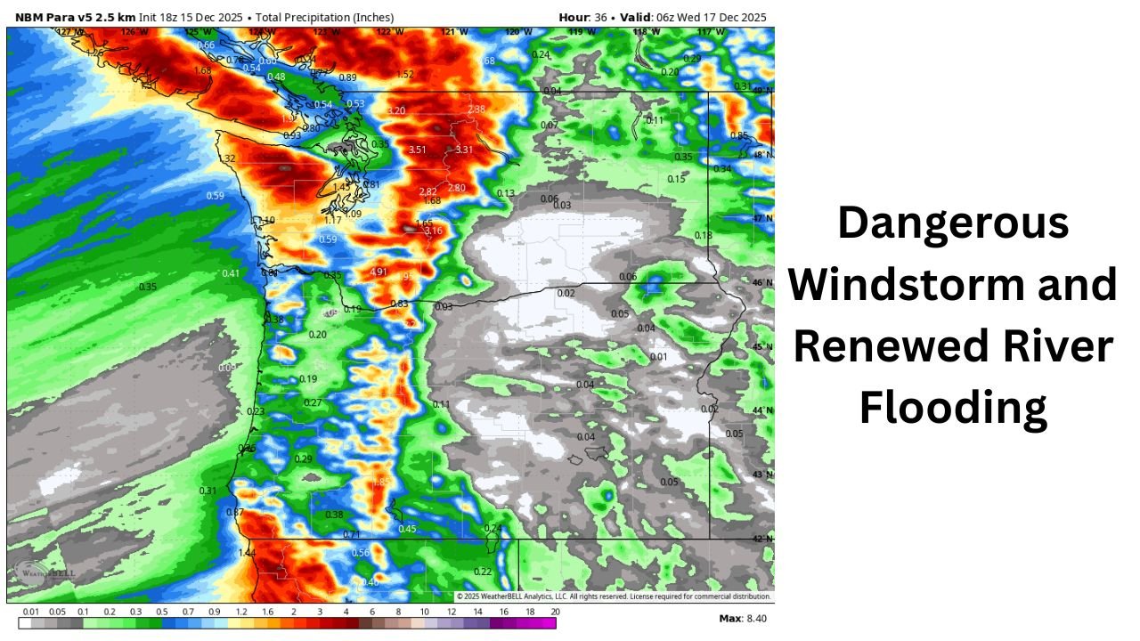
WASHINGTON, OREGON — A powerful and fast-moving series of Pacific storms is preparing to strike the Pacific Northwest from Tuesday through Thursday, bringing region-wide damaging winds, heavy mountain snow, and renewed flooding concerns for rivers already swollen from last week’s historic rainfall. Forecast models and National Weather Service alerts show a high-impact setup developing, with multiple hazards expected from the coast to the Cascades and across interior Washington and Oregon.
A Major Windstorm Arrives Tuesday Into Wednesday
A rapidly intensifying low-pressure system will strengthen under a strong upper-level jet stream on Tuesday, creating a sharp pressure gradient across the region. This setup is expected to fuel a widespread windstorm from Tuesday afternoon through early Wednesday.
Forecast maps show sustained southerly winds building first, followed by an aggressive shift to westerly winds behind a fast-moving cold front Tuesday night.
- Widespread gusts: 40–55 mph across western Washington and western Oregon
- Stronger wind zones: 60–65 mph possible along the Washington coast, Strait of Juan de Fuca, Port Angeles, Port Townsend, and Whidbey Island
- Eastern Washington: A powerful blast of 50–70 mph wind gusts is possible early Wednesday
- Mountain Passes: Whiteout or blizzard conditions may develop as snow levels crash behind the cold front
These winds are strong enough to down trees, cause power outages, and create hazardous travel during the Tuesday night peak of the storm.
Heavy Mountain Rain, Rapidly Dropping Snow Levels, and Blizzard Risks
Before cold air arrives, 3–5 inches of new rainfall in the Cascades and Olympics will fall on already saturated soils, worsening runoff and flooding potential. Lowland totals of 0.5–1.5 inches are likely before colder air changes rain to snow in higher elevations.
Behind the front:
- Feet of mountain snow are expected through Wednesday
- Blizzard-like conditions may occur over the passes as winds strengthen and visibility collapses
- Travel could become impossible at times in the Cascades
Meteorologists warn that this snow will complicate ongoing flood-recovery efforts in areas already dealing with infrastructure damage from last week’s storms.
Flooding Expected to Worsen on Multiple Rivers
River gauges remain elevated across much of Washington, and upcoming rainfall is expected to push several waterways close to or past major flood stage again.
Rivers at highest risk include:
- Skagit River
- Snohomish River
- Skykomish River
- Snoqualmie River
- Skokomish River
- Cowlitz River
- Naches River
Because soils are saturated and basins are still recovering from historic flooding, much smaller rainfall amounts than usual can trigger rapid rises. Officials urge residents near these rivers to stay alert to new flood watches and warnings as water levels respond quickly.
Another Storm Arrives Thursday — With a Strong Atmospheric River Aimed at Oregon
The next storm system arrives Thursday, carrying another plume of Pacific moisture — this time targeting western Oregon most directly. A weaker low-pressure center passing into Washington may still generate gusty winds region-wide.
Expected impacts include:
- 30–45 mph gusts typical across western WA/OR
- Up to 50–55 mph in wind-prone regions
- Enhanced rainfall across Oregon due to a stronger atmospheric river connection
Forecasters note that uncertainty remains high, and wind impacts could increase if the low tracks farther north or deepens more than currently modeled.
Looking Ahead: Cooler Weekend, Possible Lowland Snow, and Continued Active Pattern
Cooler air settles in by the weekend, potentially lowering snow levels enough for lowland flakes in parts of the region. More storms appear to be lining up in the Pacific, ensuring that the active pattern continues into next week.
Residents across Washington and Oregon should remain prepared for:
- Additional rounds of rain
- Strong winds
- Ongoing river flooding
- Difficult mountain travel
Stay Prepared and Stay Safe
With two storms arriving in quick succession, conditions across the Pacific Northwest may deteriorate rapidly. Continue monitoring updates from the National Weather Service, local emergency managers, and regional river forecasts.