Intense Cyclogenesis Over Wyoming, Montana, and the Dakotas Triggers Major Low-Level Wind Response Across the United States
Wyoming — A Rapidly Deepening Storm System Is Reshaping the Atmosphere Over North America, A powerful mid-latitude cyclone developing on the lee side of the northern Rockies—centered over Wyoming, Montana, and the Dakotas—is triggering a massive atmospheric response across much of the United States, according to new mesoscale analysis maps reviewed Wednesday evening.
Meteorologists describe this setup as intense cyclogenesis, where surface pressure drops rapidly as a storm strengthens. The provided charts show extremely tight pressure gradients over the northern Plains, with isobars packed so closely together that damaging winds become a natural consequence.
Strong Pressure Gradient Over WY/MT/Dakotas Driving Widespread Wind Fields
Analysis from the NOAA Storm Prediction Center shows:
- Deepening low pressure over eastern Montana and the Dakotas
- Very intense pressure gradient force, highlighted in the imagery
- Winds accelerating toward the low as the atmosphere attempts to “fill the void” created by falling pressure
This process generates broad low-level wind fields, which can extend hundreds of miles from the storm center.
The data indicates wind acceleration is occurring not just in the core of the storm but across large portions of the central United States due to the magnitude of the pressure falls.
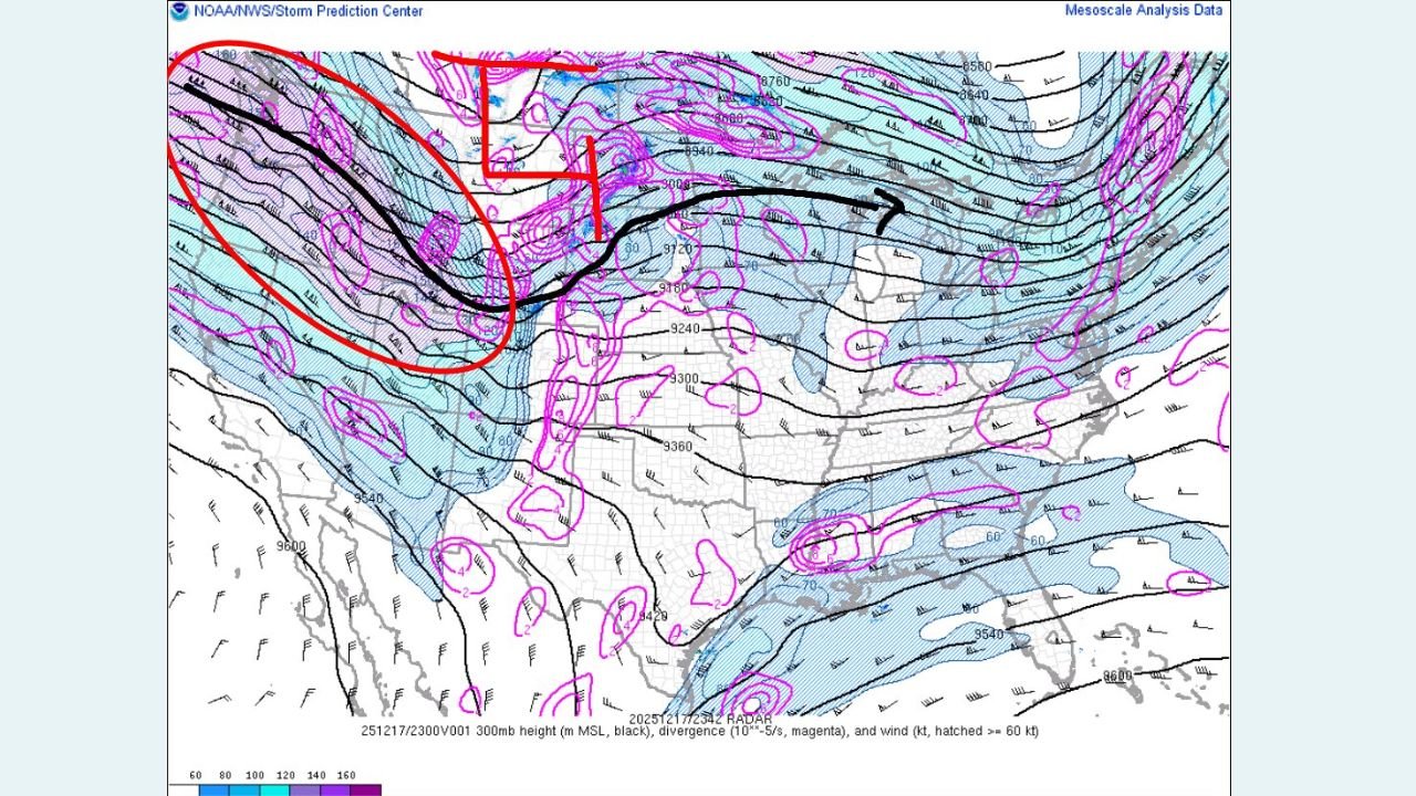
Powerful Upper-Level Trough Enhancing Lift and Intensifying the Storm
A second graphic shows a robust 300-mb trough digging into the Pacific Northwest, providing crucial upper-level energy for storm deepening. Key features include:
- Strong jet streaks diving southeastward
- Areas of upper-level divergence, shown in magenta
- Enhanced lift over the northern Rockies and High Plains
This upper-level support helps accelerate pressure falls at the surface, strengthening the storm even further.
Meteorologists note that when the upper-level trough aligns with strong surface features—as seen in the provided maps—rapid intensification becomes much more likely.
Large-Scale Mass Response Developing Across the United States
Because of the storm’s intensity, surrounding regions are reacting in several ways:
- Air over the central and eastern U.S. is rushing toward the deepening low, creating strong surface winds
- The western U.S. is experiencing jet-stream-driven lift, feeding energy into the system
- Downstream areas, including the Midwest and Great Lakes, may feel enhanced winds and shifting temperature patterns
While this dataset does not include precipitation outcomes, historical analogs indicate these setups often precede:
- High wind warnings across Plains states
- Snow and blizzard-type conditions near the low center
- Rapid temperature swings as air masses collide
More detailed regional impacts will become clearer as updated model runs arrive.
Why This System Matters
Events like this—driven by strong cyclogenesis and significant pressure gradients—can influence weather across thousands of miles. Even areas far from the storm center may experience notable effects, including:
- Increased wind gusts
- Turbulent aviation conditions
- Rapid changes in temperature
- Shifting storm tracks downstream over the Great Lakes and Northeast
Meteorologists will continue monitoring this system as it evolves, especially given the strong signals of upper-level support and widespread mass response.
Stay With Chicago Music Guide for Weather Updates
As this dynamic system continues to develop, our team will provide updated coverage to help readers stay informed about changes affecting travel, holiday plans, and local conditions nationwide.
For ongoing weather insights and community reporting, keep following ChicagoMusicGuide.com.