Colorado Front Range Braces for Another Damaging Wind Event as Mountain Wave Setup Promises Gusts Near 100 MPH
Colorado — A significant and potentially damaging wind event is forecast to develop Friday along the Colorado Front Range, where models continue to show wind gusts approaching 100 mph. This storm setup strongly resembles a classic mountain wave event, the type known to produce sudden and severe surface wind bursts east of the foothills.
Forecast data shows a sharp ribbon of extreme gust potential aligned directly with the Front Range corridor. These winds are expected to peak during the late morning and afternoon hours, with several communities from Boulder to Colorado Springs likely to experience the strongest impacts.
Mountain Wave Dynamics Could Intensify the Event
Meteorologists emphasize that this setup is not a typical high-wind pattern, but a pure mountain wave event, where strong upper-level flow interacts with the terrain of the Rockies and forces intense downward motion of air.
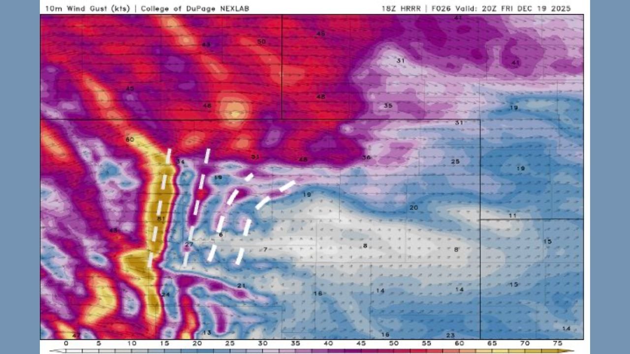
The annotated HRRR model imagery highlights:
- White-dashed lines indicating the wave crest, descending off the foothills
- A linear zone of near-surface wind maxima forming east of the mountains
- Repeated bursts of extreme gusts, not just a single peak period
These wave-driven wind events are notoriously dangerous. When air accelerates downward along the lee slopes, gusts can rapidly intensify with little warning, sometimes reaching hurricane-force levels well away from any thunderstorm activity.
Fire Weather Concerns Add Additional Risk
Strong, dry downslope winds may worsen fire weather potential across portions of eastern Colorado. Even a small spark under these conditions can lead to difficult-to-control fire behavior.
Officials are urging residents to:
- Secure outdoor objects
- Avoid activities that may generate sparks
- Prepare for possible power outages
- Use caution if traveling, especially along north–south highways where crosswinds may be severe
Communities directly under the mountain-wave axis — including Boulder, Golden, Castle Rock, and Colorado Springs — should remain especially alert.
What’s Next
Forecasters will refine the timing and intensity overnight as updated model guidance becomes available. However, confidence remains high that Friday will bring a dangerous and high-impact wind day for much of the Colorado Front Range.
Chicago Music Guide will continue to monitor the situation and provide updates as conditions evolve.