Massachusetts, New York and Pennsylvania Face Quick-Hitting Alberta Clipper Tuesday With Snow and White Christmas Potential
BOSTON, MASSACHUSETTS — A fast-moving Alberta Clipper is expected to sweep across parts of the Northeast on Tuesday, bringing a brief period of accumulating snow to New York, Massachusetts, and Pennsylvania, with some communities getting a realistic shot at a White Christmas, according to the latest forecast guidance.
Snow Timeline and Storm Setup
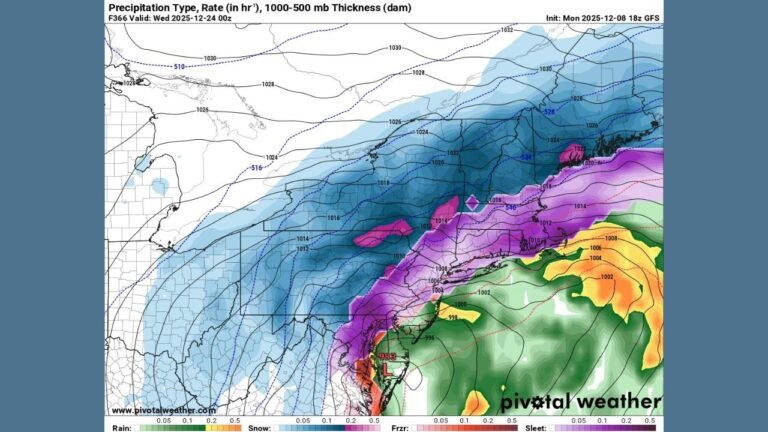
Forecast models show the clipper racing east from the Great Lakes early Tuesday, spreading snow into central and eastern Pennsylvania first, then moving across upstate New York and into interior New England by midday and afternoon. Because the system is progressive and moisture-limited, snowfall rates are expected to be light to moderate, but enough for visible accumulation in colder inland areas.
The system is driven by a compact upper-level disturbance and a tight thermal gradient, allowing snow to develop quickly once lift increases. Coastal locations may see precipitation mix with or change to rain, while inland and higher-elevation areas remain cold enough for snow throughout the event.
Areas Most Likely to See Accumulation
Based on current model consensus, the most favored zones for accumulating snow include:
- Interior and upstate New York, including the Hudson Valley, Catskills, Mohawk Valley, and areas north toward the Capital Region
- Central and northeastern Pennsylvania, especially higher terrain away from the immediate Maryland border
- Interior Massachusetts, including western and central portions of the state, with lighter amounts closer to the coast
Snowfall amounts are expected to stay on the lighter side, generally ranging from a coating to a few inches, but that may be enough to leave snow on the ground heading into Christmas Eve in colder locations.
Coastal Impacts and Mixing Concerns
Along the immediate coast, including parts of southeastern Pennsylvania, coastal New York, and eastern Massachusetts, slightly warmer air may intrude during the day Tuesday. This could lead to rain or a rain-snow mix, limiting accumulation and potentially washing away snow by Tuesday evening.
Farther inland, colder surface temperatures and slower melting rates increase the odds that snow cover persists.
Why This Storm Matters for Christmas
Even modest snowfall from a clipper system can be significant this late in December, especially after recent mild stretches. If snow accumulates Tuesday and nighttime temperatures remain cold, snowpack could survive into Christmas morning, giving parts of the Northeast their best chance at a White Christmas this year.
However, forecasters caution that small track shifts could still influence who sees snow versus rain, particularly near coastal transition zones.
What to Watch Next
- Exact placement of the rain-snow line
- Timing of peak snowfall during the day Tuesday
- Overnight temperatures following the storm
Forecast confidence is moderate, and updates are expected as higher-resolution guidance refines snowfall placement.
For continued weather updates and how upcoming conditions may impact travel, holiday plans, and events, stay connected with ChicagoMusicGuide.com as this developing Northeast snow chance becomes clearer.