New York Winter Storm Threat Grows as Snow, Ice, and Rain Target NYC and Tri-State Area Late Friday Into Saturday

NEW YORK – A developing winter storm is becoming increasingly likely to impact New York City, New Jersey, and parts of southern New England from Friday afternoon through early Saturday, with accumulating snow, mixed precipitation, and hazardous travel conditions possible across the region.
Forecast models remain inconsistent on the exact storm track, but recent guidance shows a strengthening coastal system moving northeast while cold air remains in place across the interior Northeast. This setup raises the potential for accumulating snowfall in and around NYC, with higher totals favored just west and north of the city.
Snow Accumulation Outlook by Region
Based on the latest GFS, ECMWF, and ensemble snowfall guidance, multiple impact zones are emerging:
- Interior New Jersey, Lower Hudson Valley, Northeast Pennsylvania:
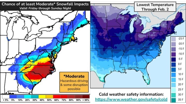
These areas currently have the highest confidence for accumulating snow, with 3 to 6 inches likely, and localized totals exceeding 6 inches where snow bands persist longest. - New York City and Long Island:
NYC remains on the sharp gradient between rain and snow. Current projections support 2 to 4 inches, though totals could shift significantly depending on storm track and surface temperatures. Eastern Long Island may see lower totals if rain mixes in. - Southern New England:
Coastal Connecticut and Rhode Island may see light to moderate snow, while interior sections have better odds for accumulation if colder air holds.
Timing: When Conditions Will Deteriorate
Snow is expected to develop Friday evening, intensifying overnight as the storm strengthens offshore. The most impactful period appears to be:
- Friday: 7 PM – Midnight: Snow overspreads the region
- Overnight Friday into Early Saturday: Heaviest snow rates and reduced visibility
- Saturday Morning: Snow tapers off west to east, with lingering slick roads
Light snow or flurries could linger into Saturday daytime, especially north and west of the city.
Travel and Safety Concerns
Even modest snowfall amounts may result in dangerous travel conditions, particularly during the overnight hours when temperatures remain near or below freezing. Forecast soundings indicate a risk for brief sleet or freezing rain, especially south of NYC, which could worsen road conditions.
Officials urge residents to prepare for:
- Slippery roadways
- Delays on bridges and elevated highways
- Reduced visibility during heavier snow bands
Forecast Confidence Remains Moderate
Meteorologists stress that this event still requires close monitoring. A shift of 50–100 miles in the storm track could dramatically alter snowfall totals for NYC and surrounding suburbs. While confidence is growing that winter weather will occur, exact impacts are still uncertain.
Updates are expected as higher-resolution models refine the storm’s path and thermal profile.
What This Means for Chicago Music Fans Traveling East
For Chicago-area travelers heading to New York, New Jersey, or New England this weekend, flight delays and cancellations are possible late Friday into Saturday morning. Concertgoers and holiday travelers should monitor airline advisories and allow extra time for ground transportation.
Stay Informed
This system will continue to evolve rapidly. Residents across the Tri-State area should stay tuned for updated forecasts, winter weather advisories, and potential travel alerts as confidence increases.
ChicagoMusicGuide.com will continue tracking this storm and its impacts as new data becomes available.