Michigan Freezing Rain Threat Builds for December 26–27 as Ice Accumulations Target I-96 Corridor and Southern Lower Peninsula
MICHIGAN — A dangerous winter weather setup is taking shape across Michigan beginning Friday morning, December 26, 2025, as a strengthening low-pressure system pushes into the Great Lakes, bringing a complex mix of freezing rain, sleet, snow, and rain that could leave roads, sidewalks, and power lines coated in ice well into Saturday.
Forecast data and regional model guidance show freezing rain becoming the dominant threat across much of the Lower Peninsula, with the highest ice accumulations likely along and near the I-96 corridor in southeastern Michigan, including areas around Lansing, Brighton, Jackson, and toward the Detroit metro region. Northern zones are more likely to see snow and sleet, while southwestern Michigan may briefly transition to plain rain before colder air locks back in.
Ice Accumulation and Freezing Rain Risk Across Southern Michigan
The most concerning element of this storm is the potential for freezing rain to accumulate quickly on untreated surfaces. Forecast discussions indicate ice accretion rates of 0.025 to 0.05 inches per hour, which is enough to rapidly turn roadways into ice rinks, especially during the morning and midday hours Friday.
Model consensus suggests localized ice totals approaching or exceeding 0.10 inches in parts of southeastern Michigan, particularly along I-96 and adjacent counties. Even smaller amounts of ice can lead to widespread vehicle accidents, downed tree limbs, and scattered power outages, especially if freezing rain persists longer than currently projected.
Meteorologists note this remains a conservative forecast, as small shifts in the storm track could increase ice totals significantly in a narrow corridor.
Snow and Sleet to Impact Northern and Western Regions
While freezing rain dominates the southern half of the state, northern Michigan — including areas near US-10 and toward the Upper Peninsula — is expected to see more snow and sleet, though amounts remain uncertain.
Snowfall rates may briefly intensify within narrow bands of heavier precipitation, especially where cold air is deepest. However, forecasters caution that minor shifts of just 50 to 100 miles in the storm’s track could dramatically change who sees moderate snow versus mixed precipitation.
In western Michigan, including areas near Kalamazoo, Holland, Muskegon, and Ludington, light ice accumulation — referred to as glaze icing — remains possible, with totals generally lower but still hazardous for travel.
Timing and Duration of Impacts
The first round of precipitation is expected to move in after midnight Thursday night, with freezing rain developing as early as 8 a.m. EST Friday across parts of western Michigan. By midday Friday, impacts are expected to become statewide, coinciding with some of the coldest surface temperatures of the day.
One major concern is that surface temperatures may not rebound above freezing once the precipitation ends. As a result, icy conditions could persist Friday night into Saturday, particularly on secondary roads, bridges, and untreated surfaces.
Travel conditions are expected to remain dangerous well into Saturday morning, even after precipitation tapers off.
Temperature Trends Reinforce Ice Risk
Daytime high temperatures on Friday are forecast to remain only in the 30s across southern Michigan, with 40°F possible in far southwestern areas and 20s across northern zones. The colder trend is tied to a southward-displaced jet stream, which is now firmly positioned below the Great Lakes region.
This pattern eliminates the possibility of rapid melting, meaning any ice that forms is likely to linger, increasing the risk for extended travel disruptions and hazardous conditions.
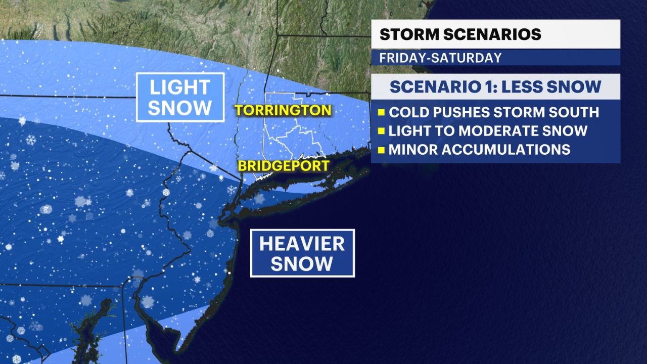
Additional Snow Scenarios for the Northeast
While Michigan faces its primary ice threat, forecast models also highlight a separate winter storm scenario for parts of the Northeast, including Connecticut, New York City, and coastal New England, from Friday night into Saturday.
In this region, two competing scenarios remain on the table:
- One favors lighter snowfall if cold air suppresses moisture southward.
- The other supports moderate to locally heavy snowfall, especially across western Connecticut, where 4–8 inches of snow could develop if moisture remains locked in place.
Forecasters emphasize that minor adjustments in storm positioning will determine whether areas like Bridgeport and Torrington experience light snow or several inches.
Safety and Travel Outlook
With freezing rain, sleet, snow, and sub-freezing temperatures all in play, officials urge residents to avoid unnecessary travel on Friday, especially during the morning and afternoon hours. Drivers should prepare for rapidly changing road conditions, limited traction, and reduced visibility.
Those with travel plans should monitor local advisories and updates, ensure vehicles are winter-ready, and allow extra time if travel cannot be postponed.
As this storm system evolves, updated forecasts may refine ice and snow placement, especially given the narrow margins between rain, sleet, and snow. For continuing coverage, weather updates, and regional impact breakdowns, visit ChicagoMusicGuide.com for the latest winter weather developments.