Pennsylvania, New York, and New England Face Potential Winter Storm With Snow, Sleet, and Freezing Rain Expected December 26–27
NEW YORK — A developing winter storm system is drawing close attention across the Northeast as forecasters warn of a complex mix of snow, sleet, and freezing rain that could impact travel and daily routines from late Friday into Saturday, December 26–27. While forecast details are still being refined, early projections show the highest risk for disruptive winter weather stretching from central Pennsylvania through upstate New York and into parts of New England.
Meteorologists stress that this is not a finalized snowfall forecast, but rather an early-stage projection designed to highlight where the storm could have the greatest impact as colder air interacts with incoming moisture.
What the Early Forecast Shows
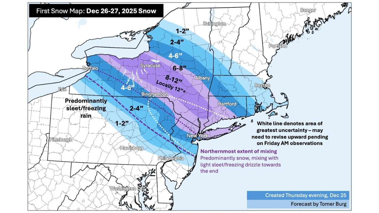
Initial snow maps indicate a broad swath of accumulating snow across interior sections of the Northeast, with totals varying significantly by location:
- Central and northern Pennsylvania: Generally 1–4 inches, with pockets of mixed precipitation, including sleet and freezing rain.
- Upstate New York: A corridor from the Finger Lakes through the Mohawk Valley could see 6–8 inches, with locally higher totals up to 12 inches if colder air holds longer.
- Southern New England: Areas inland from the coast may pick up 2–6 inches of snow, while coastal zones face a higher risk of mixing or a late changeover to freezing drizzle.
Forecasters note that western Pennsylvania and parts of the interior Mid-Atlantic may experience predominantly sleet or freezing rain, which can cause hazardous road conditions even where snowfall totals remain modest.
Why Forecast Confidence Is Still Limited
This storm is considered highly sensitive to small temperature changes, particularly near the surface. A narrow zone—often called the “mixing line”—separates snow from sleet and freezing rain, and its exact placement remains uncertain.
Weather experts emphasize that:
- A 1–2 degree temperature shift could dramatically alter precipitation type.
- The heaviest snow axis may shift north or south as new data becomes available.
- Friday morning atmospheric observations will be critical in refining snowfall and icing forecasts.
Because of this uncertainty, some areas highlighted for moderate snowfall could ultimately see lower totals due to mixing, while others could exceed current projections.
Timing and Travel Impacts
Current guidance suggests:
- Snow and mixed precipitation may begin late Friday, increasing in intensity Friday evening.
- Overnight Friday into early Saturday appears to be the most impactful period for interior locations.
- Saturday morning travel could be difficult due to snow-covered roads, icy surfaces, and reduced visibility.
Even areas receiving lighter snow totals may experience dangerous conditions if freezing rain or sleet develops, particularly on untreated roads, bridges, and overpasses.
What Residents Should Do Now
While the forecast will continue to evolve, residents across the affected regions are encouraged to:
- Monitor updated forecasts through Friday.
- Prepare for possible travel delays or cancellations.
- Allow extra time for weekend travel plans.
- Be especially cautious in areas prone to icing, where even small accumulations can lead to power outages or hazardous driving.
Meteorologists are expected to issue refined snowfall maps and advisories once higher-confidence data becomes available.
Why This Storm Matters
Late-December storms often carry added risks due to holiday travel, colder ground temperatures, and overnight freezing, which can worsen road conditions quickly. Even if final snowfall totals change, the combination of snow, sleet, and freezing rain makes this a system worth watching closely across Pennsylvania, New York, and New England.
As always, continue checking official updates as new observations come in. Weather conditions can change rapidly, and the final outcome may look different than early projections.
Stay alert, stay prepared, and follow Chicagomusicguide.com for continued weather updates and regional impact coverage.