Freezing Rain Threat Persists Across Pennsylvania as Winter Weather Advisory Targets Areas North and East of Pittsburgh
PITTSBURGH, PENNSYLVANIA — A lingering freezing rain threat continues across portions of Pennsylvania, particularly north and east of Pittsburgh, as surface temperatures remain at or below freezing in several areas. Weather officials warn that slick travel conditions are possible through the afternoon, especially along ridge-top communities and major travel corridors including Interstate 80 and U.S. Route 422.
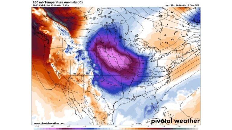
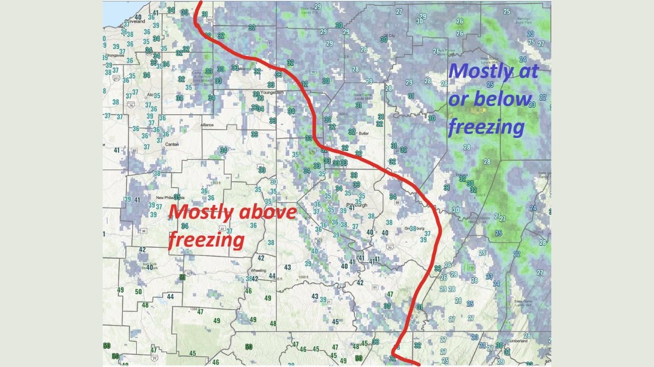
Forecasters say the sharp temperature divide across western and central Pennsylvania is playing a key role, with areas south and west of Pittsburgh remaining mostly above freezing, while colder air holds firm to the north and east.
Where Freezing Rain Remains Most Likely
According to the latest temperature and radar analysis, below-freezing readings are concentrated north and east of Pittsburgh, including portions of northwestern Pennsylvania, the Laurel Highlands, and ridge-focused terrain farther east. These areas remain most vulnerable to freezing rain and icy surfaces, particularly on untreated roads.
Meanwhile, locations south and west of Pittsburgh are seeing temperatures largely above freezing, reducing the risk of ice accumulation. This contrast is clearly visible on regional maps, with a sharp boundary separating safer travel areas from higher-risk zones.
Winter Weather Advisory Adjustments Expected
Meteorologists note that adjustments to the Winter Weather Advisory area are expected later today as temperatures fluctuate and precipitation shifts. Officials caution that even small temperature changes of one to two degrees could significantly expand or reduce icing impacts.
Residents in advisory areas are urged to stay alert for updated alerts and advisories, as freezing rain risks may shift closer to or farther from the Pittsburgh metro depending on how quickly temperatures rise.
Travel Concerns Along I-80 and US-422
Transportation officials are urging extra caution along I-80 and U.S. Route 422, where freezing rain could create slick spots, particularly on bridges, overpasses, and elevated roadways. These routes are especially vulnerable due to colder surface temperatures and exposure to freezing drizzle.
Drivers are advised to reduce speeds, increase following distances, and allow extra travel time if heading through northern or ridge-top regions this afternoon.
Why the Temperature Divide Matters
Forecasters explain that cold air trapped near the surface, especially in higher elevations, is allowing rain to freeze on contact, even while nearby areas remain safely above freezing. This setup makes icing highly localized but potentially dangerous, catching drivers off guard when conditions change suddenly over short distances.
This type of event often leads to isolated but impactful travel hazards, rather than widespread disruption, making situational awareness especially important.
What to Expect Next
As the afternoon progresses, temperatures are expected to gradually rise in some locations, which could reduce icing concerns. However, forecasters stress that shaded areas and elevated surfaces may remain icy longer, even if air temperatures climb just above freezing.
Residents across western and central Pennsylvania are encouraged to monitor weather updates closely and use caution when traveling, particularly in advisory zones.
As Pennsylvania continues to navigate this late-season winter weather setup, staying informed and prepared remains essential. For ongoing weather updates, regional advisories, and travel-impact coverage, visit ChicagoMusicGuide.com.