Ohio Valley and Midwest Severe Weather Threat Could Bring Damaging Winds and Isolated Tornadoes Across Illinois, Indiana, and Kentucky on December 28
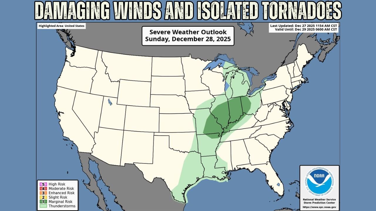
INDIANA — Forecasters are warning that severe weather is possible Sunday afternoon and evening across large portions of the Ohio Valley and Midwest, with damaging winds and a limited tornado threat as the primary concerns. The Storm Prediction Center’s Severe Weather Outlook for Sunday, December 28, 2025, highlights a broad risk area stretching from the Lower Mississippi Valley northward into the Great Lakes, placing several Midwestern states under heightened monitoring.
While the overall threat is not expected to be widespread, meteorologists caution that a few storms could become strong enough to cause localized damage, especially during peak afternoon hours.
Illinois and Indiana Face Highest Risk Zone
The most concentrated area of concern is centered over Illinois and Indiana, where atmospheric conditions appear most favorable for organized thunderstorms. Increasing wind energy aloft combined with sufficient surface moisture may allow storms to strengthen quickly once they develop.
Forecasters note that damaging straight-line winds are the most likely hazard, with gusts capable of downing trees, damaging power lines, and causing sporadic power outages. While the tornado risk remains low, a brief, isolated tornado cannot be ruled out, particularly with any storm that becomes semi-discrete.
Ohio Valley Sees Expanding Storm Potential
The severe weather threat extends eastward into Ohio and parts of Kentucky, where storms are expected to maintain some strength as they progress during the evening. In these areas, gusty winds and heavy rainfall are the primary hazards, with storms gradually weakening as they move farther east.
Forecasters emphasize that even weakening storms can still produce sudden wind bursts, which may pose risks to drivers and outdoor activities.
Southern Extension Into the Lower Mississippi Valley
Storm potential also stretches south into portions of the Lower Mississippi Valley, where thunderstorms may develop earlier in the day. While instability is somewhat limited in these areas, strong wind gusts remain possible within heavier storm cores.
The broad north-to-south extent of the risk area reflects a dynamic storm system interacting with warmer air ahead of an advancing cold front.
Why the Severe Weather Risk Is Limited but Notable
This setup is classified as a low-end severe weather event, meaning storms are expected to be scattered rather than widespread. However, forecasters stress that low-coverage events can still be impactful, especially when storms develop during daytime hours and affect populated corridors.
The presence of strong winds aloft increases confidence in wind-related impacts, even if storm coverage remains uneven.
What Residents Should Watch For
Residents across the impacted states are encouraged to remain alert for rapid weather changes Sunday afternoon, particularly if storms intensify quickly. Securing loose outdoor items, monitoring weather alerts, and staying informed through local forecasts are recommended precautions.
As this storm system moves east and colder air follows behind it, it will also contribute to significant winter weather threats elsewhere, highlighting the complex nature of this late-December pattern.
For continued updates on Midwest and Ohio Valley weather, severe storm outlooks, and evolving conditions, visit ChicagoMusicGuide.com for the latest coverage.