Minnesota Blizzard Warning Upgraded as Powerful Winter Storm Brings Dangerous Travel, 6–8 Inches of Snow, and Wind Gusts Up to 55 MPH
MINNESOTA — A major winter storm intensifying across the Upper Midwest has prompted forecasters to upgrade portions of western and central Minnesota to a Blizzard Warning, replacing an earlier Winter Storm Watch. While snowfall totals in some areas may be lower than initially expected, officials say the combination of snow and extremely strong winds will create life-threatening travel conditions from Sunday into Monday.
According to updated forecasts from the National Weather Service Twin Cities office, wind gusts approaching 55 mph will dramatically reduce visibility, producing blowing and drifting snow capable of creating near-whiteout conditions across large portions of the state.
Blizzard Warning Now in Effect for Central and Southern Minnesota
The most serious conditions are expected across central and southern Minnesota, where Blizzard Warnings are now active. These areas include communities west and south of the Twin Cities, where persistent snowfall combined with powerful northwest winds will make travel extremely hazardous.
Even where snowfall totals remain moderate, forecasters stress that wind-driven snow will severely limit visibility, making it difficult for snowplows to keep roads passable. Officials warn that travel could become dangerous or impossible, particularly during peak wind periods late Sunday and overnight.
Snowfall Totals Vary Across Minnesota and Western Wisconsin
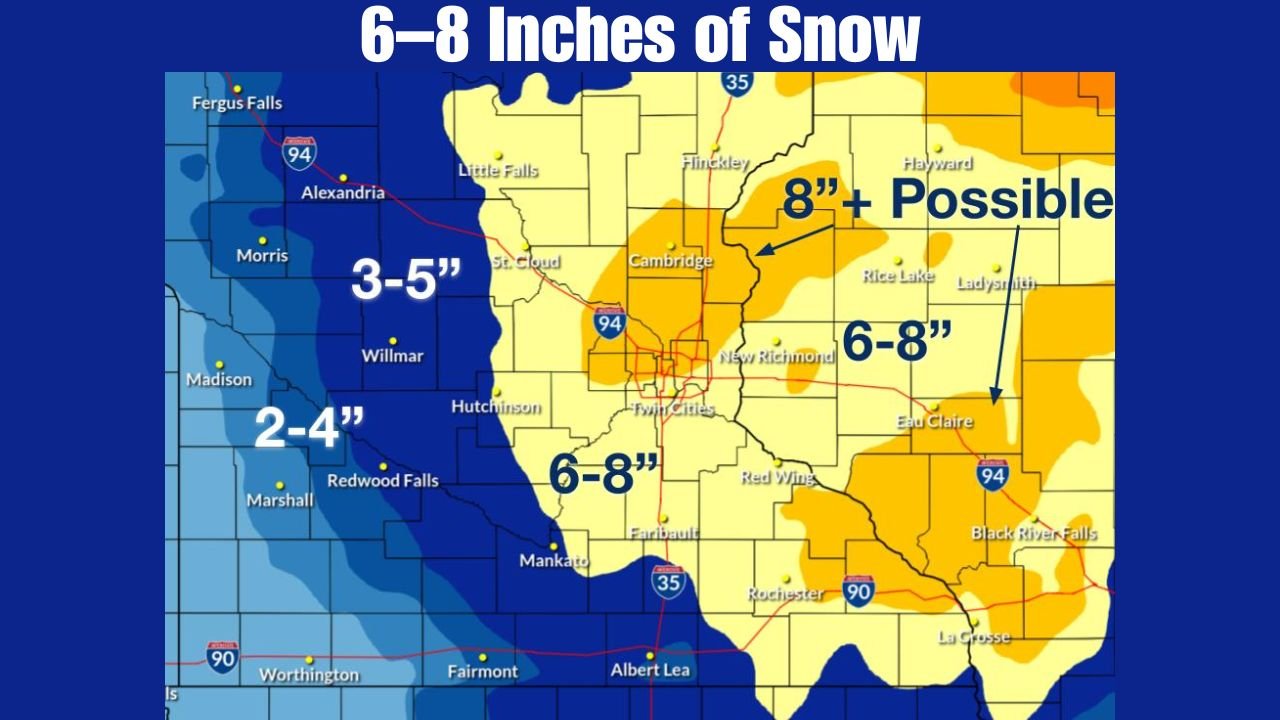
Snowfall forecasts show a clear regional split across the storm zone. In eastern Minnesota, including the Twin Cities metro area, snowfall totals are expected to range between 6 and 8 inches, with some isolated spots possibly exceeding 8 inches.
Farther west across western Minnesota, snowfall totals are lower, generally in the 2 to 5 inch range, but the blizzard designation remains due to extreme wind speeds. Meanwhile, western Wisconsin is expected to receive 6 to 8 inches of snow, with Winter Storm Warnings remaining in effect.
Forecasters emphasize that snowfall amounts alone do not reflect the storm’s severity, as wind impacts will play a major role in overall conditions.
Wind Gusts Up to 55 MPH Create Whiteout Conditions
One of the most dangerous aspects of this storm is the exceptionally strong wind field. Forecast wind data shows sustained northwest winds of 30 to 40 mph, with gusts frequently reaching 45 to 55 mph across much of Minnesota.
These winds will loft snow into the air, drastically reducing visibility and leading to rapidly changing road conditions. Even after snowfall tapers off, blowing and drifting snow is expected to continue into Monday, prolonging travel hazards.
Rapid Temperature Drop Increases Ice Risk
As the storm progresses, temperatures will fall sharply Sunday night, dropping below freezing across the region. Any remaining moisture on roadways will freeze quickly, increasing the risk of black ice, especially on untreated surfaces.
The combination of falling temperatures, heavy snow, and strong winds is expected to result in very hazardous travel conditions, particularly overnight and during the Monday morning commute.
Officials Urge Residents to Avoid Travel
Emergency managers strongly advise residents to avoid unnecessary travel, especially in Blizzard Warning areas. Those who must travel are urged to carry winter survival kits, allow extra time, and stay informed through official weather updates.
Forecasters stress that this storm’s danger lies not just in snow totals, but in the prolonged duration of wind and poor visibility, which could strain emergency response and road-clearing efforts.
As the winter storm continues to evolve, residents are encouraged to closely monitor warnings and forecasts. For ongoing updates on Midwest winter storms, weather alerts, and regional impacts, continue following coverage on ChicagoMusicGuide.com.
Author: Leo Hart