Florida Braces for Rare New Year’s Eve Arctic Blast as Wind Chills Drop Into the 20s and 30s Statewide
FLORIDA — A powerful Arctic air mass is pushing deep into the Sunshine State ahead of New Year’s Eve, bringing unusually cold wind chills that will stretch from North Florida all the way into South Florida and the Everglades, according to the latest forecast data.
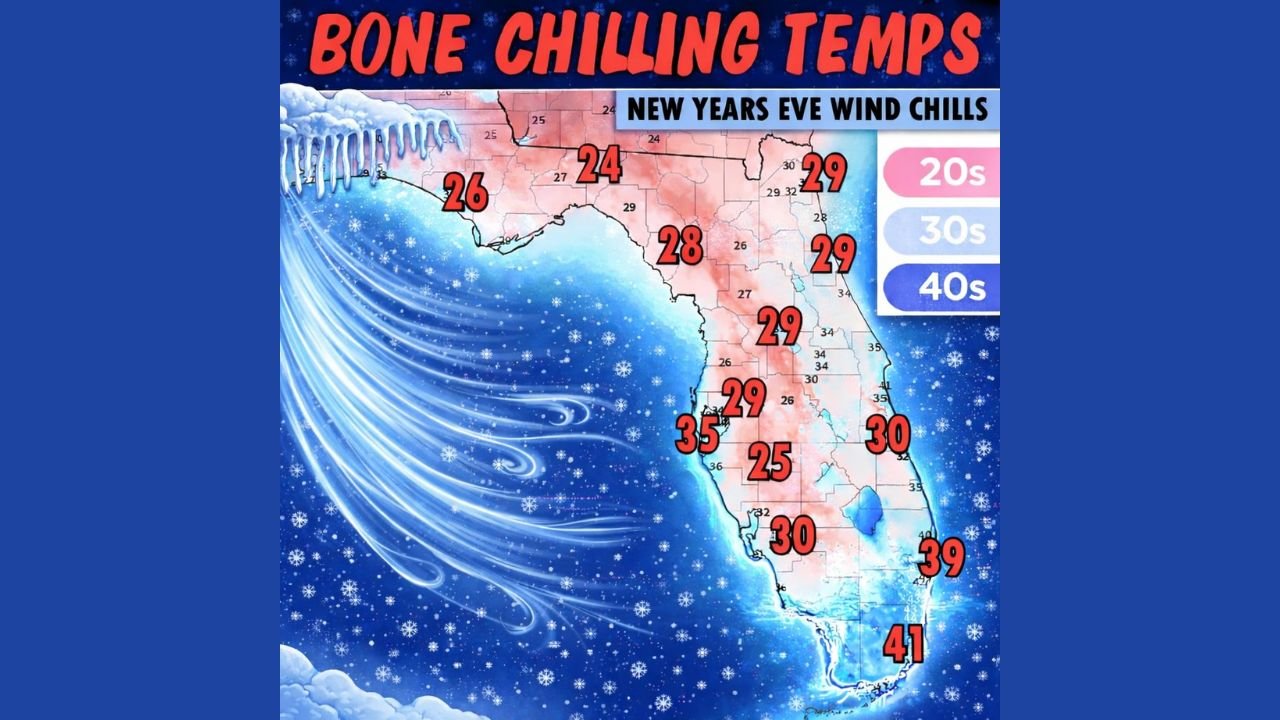
The wind-chill map shows bone-chilling conditions statewide, with much of Florida feeling temperatures more typical of winter in the Midwest than the Deep South. This cold blast is expected to peak during New Year’s Eve morning and early hours, before gradually easing after January 1.
Wind Chills Plunge Across Florida as Arctic Air Pushes South
The most striking signal from the data is just how far south the cold air reaches.
Across North Florida and the Panhandle, wind chills are expected to drop into the mid-20s, with some areas feeling as cold as 24–26 degrees. These values represent a sharp departure from normal late-December conditions and could pose risks for anyone spending extended time outdoors.
Moving into Central Florida, including inland areas, wind chills are projected in the upper 20s to low 30s, with widespread readings around 28–30 degrees. Even along portions of the west coast, values hover near freezing.
In South Florida, where cold outbreaks are usually muted, the data still shows wind chills dipping into the upper 30s, with parts of far South Florida and the Keys closer to 39–41 degrees — still unusually chilly for the region.
Why This Cold Feels So Intense
The images highlight that wind chill, not just air temperature, is the main factor driving discomfort.
Strong northerly winds behind the Arctic front are stripping away body heat, making it feel significantly colder than thermometers alone suggest. This is why even areas accustomed to mild winters are experiencing “bone-chilling” conditions.
For Florida residents, this type of cold is especially noticeable because homes, clothing habits, and daily routines are not designed for sustained freezing or near-freezing wind chills.
New Year’s Eve Impact: Cold Morning, Gradual Improvement Later
According to the forecast messaging included in the image text:
- Coldest wind chills occur on New Year’s Eve
- Conditions improve after January 1
- Mornings will feel sharply colder than afternoons
The post accompanying the data notes a familiar Florida pattern: hoodies and layers in the morning, with temperatures moderating later in the day as winds ease and sunshine returns.
What Floridians Should Keep in Mind
Based strictly on the data shown:
- Limit prolonged outdoor exposure during early morning hours
- Protect pets and sensitive plants, especially in North and Central Florida
- Dress in layers, even if temperatures rise later in the day
- Expect the cold to be short-lived, not a prolonged freeze event
While this Arctic blast is intense, it is not expected to linger deep into January.
This New Year’s Eve cold snap stands out because of how far south it reaches, delivering 20s and 30s wind chills across nearly all of Florida, including regions that rarely experience such conditions. The data shows a brief but sharp Arctic intrusion — uncomfortable, attention-grabbing, but temporary.
As temperatures rebound after the first of the year, Florida will return to its more familiar winter rhythm.
How are these rare New Year’s Eve wind chills affecting your plans — outdoor events, concerts, or late-night travel? Share your thoughts and stay weather-aware with more regional updates at ChicagoMusicGuide.com.