
Active March Pattern Flip to Trigger Repeated Severe Weather from North Texas to the Ohio Valley as Above-Normal Rain Expands into Midwest
UNITED STATES — A major pattern shift is underway as we head into early March, and nearly every major model suite is signaling an above-average precipitation trend across the southern Plains, Deep South, and potentially into the Ohio Valley.
The developing setup favors multiple storm systems tracking from Texas and Oklahoma through the Mississippi Valley and into the Midwest and East, increasing the likelihood of repeated severe weather setups — including tornado potential — through at least the first half of the month.
Storm Prediction Center Already Highlights North Texas and Oklahoma
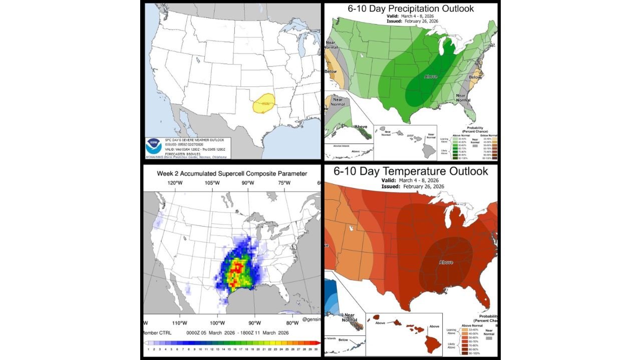
The Storm Prediction Center has already outlined a Day 6 severe weather risk area stretching from North Texas into south-central Oklahoma.
That early highlight is notable at this range and signals increasing confidence in:
- Strong thunderstorm development
- Organized severe weather potential
- The possibility of tornado-producing setups
Cities near the highlighted zone include:
- Dallas–Fort Worth
- Wichita Falls
- Ardmore
- Oklahoma City
And this appears to be just the beginning, with additional waves expected to follow.
6–10 Day Outlook: Widespread Above-Normal Precipitation
The latest 6–10 day precipitation outlook (March 4–8) shows a broad swath of above-normal precipitation probabilities extending from:
- Eastern Texas
- Oklahoma
- Arkansas
- Louisiana
- Through Mississippi, Alabama, Tennessee
- Into Kentucky and the Ohio Valley
- Northward into Illinois, Indiana, Michigan, and Wisconsin
The core of the highest precipitation probabilities stretches from the Deep South into the Midwest, signaling repeated storm tracks.
This kind of pattern often supports multiple rounds of thunderstorms rather than one isolated system.
Week 2 Supercell Composite Parameter Signals Increase
The Week 2 accumulated supercell composite parameter map highlights a corridor of enhanced severe potential from:
- Central and eastern Texas
- Through Arkansas and Louisiana
- Into Mississippi and Alabama
This aligns with the above-normal rainfall signal and suggests that atmospheric ingredients — instability, shear, and lift — may overlap repeatedly during early March.
While exact storm days are not yet pinned down, the broader pattern strongly supports active severe weather potential.
Temperature Outlook Supports Instability
The 6–10 day temperature outlook shows much of the eastern half of the country trending above normal, including:
- The Deep South
- The Tennessee Valley
- The Ohio Valley
- Portions of the Midwest
Warmer-than-average temperatures in these regions enhance the potential for Gulf moisture return and instability — key ingredients for severe thunderstorms.
Meanwhile, parts of the western U.S. trend cooler, reinforcing the amplified jet stream pattern driving this active setup.
What This Means for the Midwest and Chicago
For Chicago and the Great Lakes region, this pattern flip likely means:
- Multiple precipitation events
- Potential for strong storms on warmer days
- Possible late-season snow on the colder northern side of certain systems
Storm tracks will determine whether Chicago ends up in heavy rain, thunderstorms, or on the colder flank of a passing low.
Given the amplified jet stream configuration, small shifts in track could significantly change local impacts.
Bottom Line: Time to Prepare for an Active Stretch
Early March is shaping up to be anything but quiet.
The ingredients are coming together for:
- Repeated severe weather opportunities from North Texas into Oklahoma
- Expansion of storm chances through the Deep South and Ohio Valley
- Above-normal precipitation across the Midwest and Great Lakes
- Potential tornado setups as multiple systems eject eastward
As timing and placement become clearer in the coming days, specific risk zones will sharpen.
For now, confidence is increasing that March will open with an active, storm-driven pattern across much of the country.
Stay with ChicagoMusicGuide.com for continuing updates as this dynamic March pattern unfolds.