
Alabama Forecast Shows No Major Snowstorm Next Week as Cold Air, Not Snow, Becomes the Main Story
ALABAMA — Forecast confidence continues to grow that no major snowstorm or blizzard is expected across Alabama next week, despite widespread claims circulating on social media. Updated model guidance and ensemble data show that while very cold air will move into the state, the necessary ingredients for a high-impact snow or ice event simply are not present.
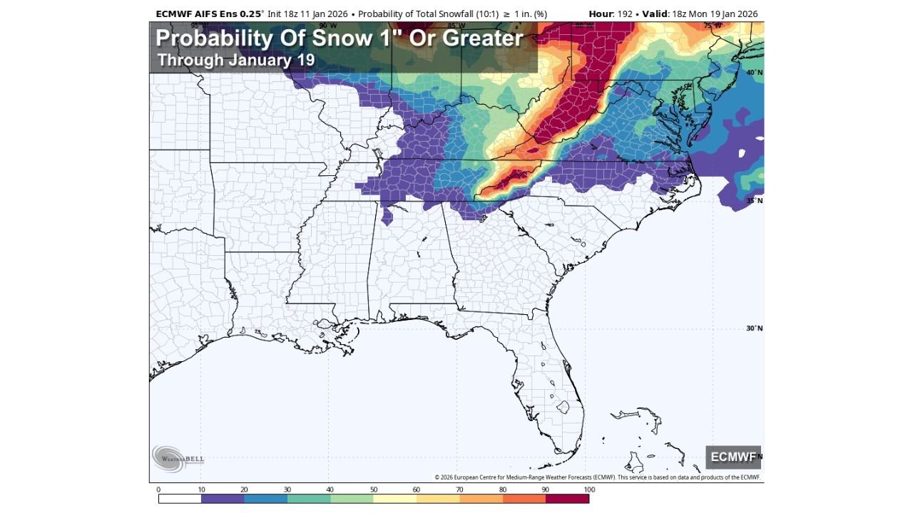
Viral Snowstorm Claims Do Not Match Forecast Data
Over the past several days, engagement-driven posts have pushed the idea of an Alabama blizzard or major snowstorm one week out, often showing exaggerated snowfall totals and emergency-style graphics. However, reliable global weather models and their ensemble members do not support these scenarios.
Current probability maps show very low chances of measurable snowfall across Alabama, with the highest snow probabilities remaining well north of the state, stretching from parts of the Ohio Valley into the Mid-Atlantic and Northeast. Across Alabama, the signal remains weak and inconsistent, pointing away from any disruptive winter storm.
Flurries Possible, But No Accumulation Expected
As a fresh surge of cold air moves into the Deep South, a few brief flurries are possible Wednesday night into very early Thursday, particularly across North Alabama. A similar setup may repeat next weekend as another cold air mass arrives.
In both cases, forecasters emphasize:
- No accumulation is expected
- No travel impacts are anticipated
- No snow or ice advisories are likely
These flurries, if they occur at all, would be cosmetic and short-lived, driven by cold air rather than organized storm systems.
Cold Air Will Be the Real Impact Across Alabama
While snow is unlikely, cold temperatures will be the dominant weather concern. Forecast lows are expected to drop into the teens across North Alabama between January 19 and January 20, marking one of the coldest periods so far this winter.
This cold air intrusion may lead to:
- Hard freezes
- Increased heating demand
- Potential stress on exposed pipes and sensitive plants
For most residents, the cold — not snow — will be the aspect of this pattern that requires preparation.
Why Alabama Is Unlikely to See a Snowstorm
Significant winter storms in the Deep South typically require precise timing between cold air and deep Gulf moisture. In this case, while cold air is present, moisture and storm organization are lacking.
Model trends continue to show:
- Cold air arriving after moisture exits
- No strong surface low near the Gulf Coast
- Limited lift and instability over Alabama
Without those elements aligning, high-impact snow or ice events cannot develop.
Forecasters caution that any forecast can change, especially beyond several days. However, based on current data, there is no meaningful snow or ice event expected for Alabama next week.
It is also worth noting that some of Alabama’s biggest snow events have historically occurred later in the season, including March and early April, when atmospheric patterns can align more favorably.
For now, the message remains clear: ignore the hype, focus on the cold, and stay informed as conditions evolve.
As winter patterns continue to shift across the Southeast, accurate information matters more than viral graphics. For continued updates on Alabama cold outbreaks, winter weather chances, and regional forecasts, visit ChicagoMusicGuide.com for the latest expert weather coverage.