Alabama, Mississippi, and Louisiana Under Low-End Tornado Risk as Early-Morning Storms Stay Disorganized
ALABAMA — A low-end severe weather threat continues across parts of Alabama, with nearby concerns extending into Mississippi and Louisiana, as early-morning storms remain largely disorganized. As of 2:30 a.m. Central Time, conditions across Alabama are mostly quiet, and there are no active tornado warnings anywhere in Alabama, Mississippi, or Louisiana.
Earlier Tornado Warning in Mississippi Has Been Canceled
An earlier tornado warning south of Jackson, Mississippi, was issued overnight after a storm briefly showed concerning characteristics. That warning has since been canceled, and no additional tornado warnings are in effect across the region at this time.
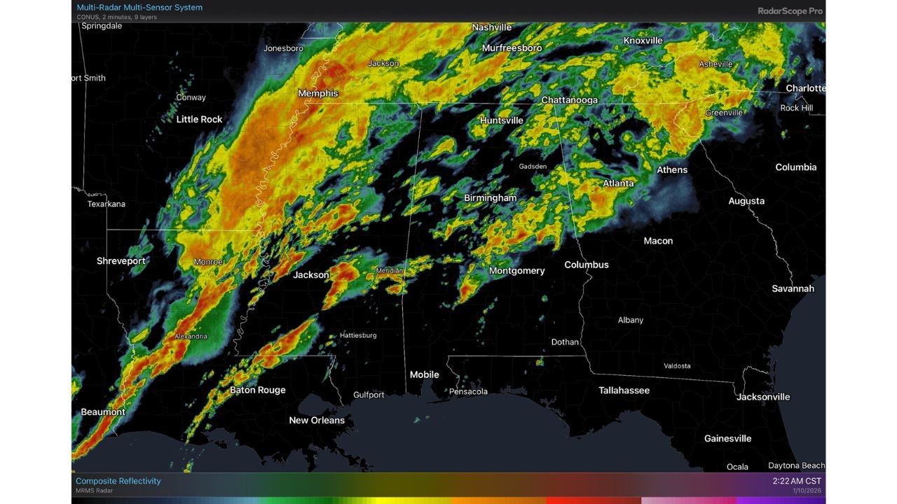
Radar imagery shows widespread rain and embedded thunderstorms stretching from Louisiana through Mississippi and into northern and central Alabama, but most storms have remained below severe thresholds so far. Forecasters note that storm intensity has fluctuated but has not yet produced sustained rotation.
Low-End Tornado Risk Continues Through Mid-Morning
Despite the relatively quiet radar presentation, meteorologists caution that the severe weather threat is not over. A low-level jet is expected to strengthen toward daybreak, interacting with a somewhat unstable air mass, particularly over southern Alabama.
As this jet intensifies, there remains a possibility of one or two isolated tornadoes developing over the next few hours. The threat is considered low-end, meaning widespread severe weather is not expected, but brief, fast-developing tornadoes cannot be ruled out, especially within embedded supercell structures.
Flood Watch Remains in Effect for Much of Alabama
In addition to the tornado concern, a Flood Watch remains in effect for the northern two-thirds of Alabama. Repeated rounds of moderate to heavy rainfall overnight have increased the risk of localized flooding, particularly in low-lying and poor-drainage areas.
Rainfall rates may periodically intensify as bands of storms move across the same locations. While widespread river flooding is not currently expected, ponding on roads, rapid rises in creeks, and isolated flash flooding remain possible through the morning hours.
Storm Mode Limiting Widespread Severe Impacts
One factor limiting the severity of this event has been storm organization. Many of the storms remain linear or loosely clustered, which reduces the likelihood of long-lived tornadoes. However, brief rotations can still occur, especially when storms interact with boundaries or localized pockets of instability.
Forecasters continue to monitor whether storms can briefly organize into supercell structures, particularly across southern Alabama and southern Mississippi, where the environment is marginally more favorable.
What Residents Should Watch For This Morning
Residents across Alabama, Mississippi, and Louisiana are urged to remain weather-aware through the early morning hours. Key concerns include:
- Brief tornado spin-ups
- Heavy rain leading to localized flooding
- Rapidly changing radar conditions before sunrise
Even without warnings currently in effect, conditions can change quickly in overnight and early-morning severe weather setups, when visibility is limited and storms can intensify with little notice.
As this system continues to evolve through mid-morning, meteorologists will maintain close radar surveillance and provide updates as needed. For continued coverage of severe weather alerts, radar updates, and regional storm impacts, visit ChicagoMusicGuide.com for the latest information.