
Alabama, North Carolina, South Carolina, Virginia and Maryland Brace as Arctic Cold and East Coast Snow Threat Intensifies This Weekend
UNITED STATES — A fresh surge of Arctic air is pushing into the Southeast and Mid-Atlantic late Friday into Saturday, while a rapidly strengthening storm system offshore raises growing concern for significant winter weather impacts along parts of the East Coast. Forecast confidence is increasing for heavy snow across the Carolinas and nearby states, even as uncertainty remains about how close the storm tracks to the coastline.
Arctic Front Brings Bitter Cold to Alabama
Another Arctic front is expected to sweep through Alabama Friday night into Saturday, bringing sharply colder air across the state. As the front moves through, light snow flurries or brief snow showers may develop, especially across north and northeast Alabama.
Widespread accumulation is not expected, but localized heavier snow showers could leave up to a quarter inch of snow in isolated spots by Saturday midday, mainly in northeast Alabama counties.
Temperatures will struggle to rise on Saturday, with highs remaining in the 20s across much of north and central Alabama after starting the morning in the teens. By early Sunday morning, single-digit lows are likely in colder pockets of north Alabama, matching the intensity of recent Arctic outbreaks earlier this week.
Limited Travel Issues Possible in North Alabama
While this is not expected to be a high-impact snow event for Alabama, brief travel issues cannot be ruled out where heavier snow showers briefly reduce visibility or coat untreated roads. Any impacts would be isolated and short-lived, rather than widespread.
Major Winter Storm Threat Grows East of Alabama
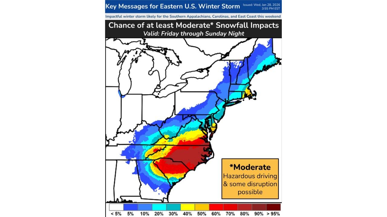
The bigger concern lies farther east. As the Arctic air presses southward and a surface low strengthens offshore, confidence continues to increase for a significant winter storm affecting the Carolinas and parts of Virginia late Saturday into Sunday.
Current projections show the highest risk for impactful snowfall across North Carolina and South Carolina, particularly from the southern Appalachians through central and eastern portions of the Carolinas. Snowfall amounts in these areas could become substantial if the storm tracks closer to the coast.
Virginia, Maryland, Delaware and New Jersey Watching Closely
Farther north, Virginia, Maryland, Delaware, and New Jersey remain in a watch zone. While confidence is lower than in the Carolinas, forecasters note that setups like this often shift northwest at the last minute, bringing heavier snow closer to the Interstate 95 corridor.
At this stage, the key question is not whether a storm develops, but how close to the coast it tracks. A slight westward shift would dramatically increase snowfall totals and impacts for coastal and urban areas.
Strong Winds and Coastal Impacts Add to the Risk
In addition to snow, strong winds are expected along portions of the East Coast. Where winds overlap with snowfall, blowing snow and sharply reduced visibility could lead to hazardous travel conditions. Along the coast, onshore winds combined with high tides may produce coastal flooding and damaging waves, especially in parts of North Carolina and Virginia.
Forecast Uncertainty Still Remains
Despite rising confidence, uncertainty remains regarding the storm’s exact track after it passes offshore Saturday night. Small shifts will determine whether impacts stay mostly offshore or push inland toward major population centers in the Mid-Atlantic and Northeast.
Residents across the entire East Coast are urged to stay alert as forecast details become clearer over the next 24 to 36 hours.
What This Means for the Weekend
- Alabama: Bitter cold, scattered flurries, isolated light snow, single-digit lows possible
- Carolinas: Increasing risk of heavy snow and significant travel disruptions
- Virginia & Mid-Atlantic: Potential snow depending on storm track
- East Coast: Strong winds, coastal flooding, and hazardous travel possible
Weather conditions can change quickly with systems like this. Stay with ChicagoMusicGuide.com for continued updates, refined snowfall projections, and impact tracking as this winter storm threat evolves. If you’re in an affected area, check back frequently and share updates from your location.