
Alabama, South Carolina, and Georgia Face Rare Southern Snow as Arctic Cold and Offshore Low Collide
ALABAMA — A surge of very cold Arctic air is settling into the state tonight, setting up one of the coldest periods of the winter so far. Forecast temperatures show much of northern Alabama stuck in the 20s on Saturday, while even southern cities like Dothan and Mobile struggle to climb above freezing during the day.
This cold air mass is the key ingredient allowing snow to develop unusually far south, especially as moisture rotates in from the east.
Snow Showers Target East and Northeast Alabama
As colder air deepens overnight, scattered snow showers are expected late tonight into Saturday morning, with the highest coverage over east and northeast Alabama.
- A Winter Weather Advisory is in effect for six east Alabama counties
- Localized snowfall totals could reach up to 1 inch, especially under heavier snow bands
- Icy patches are likely on untreated roads, bridges, and overpasses during the morning hours
Travel impacts are expected to be spotty but dangerous where snow showers briefly intensify.
Strong North Winds Add to the Danger
Beyond snow and cold, strong north winds will make conditions even harsher across Alabama on Saturday.
- Wind gusts are forecast to reach 30–40 mph statewide
- Much of Alabama remains under a Wind Advisory
- Blowing snow and rapidly dropping wind chills will make outdoor conditions feel even colder
These winds could also lead to isolated power issues, especially where trees and power lines are already stressed.
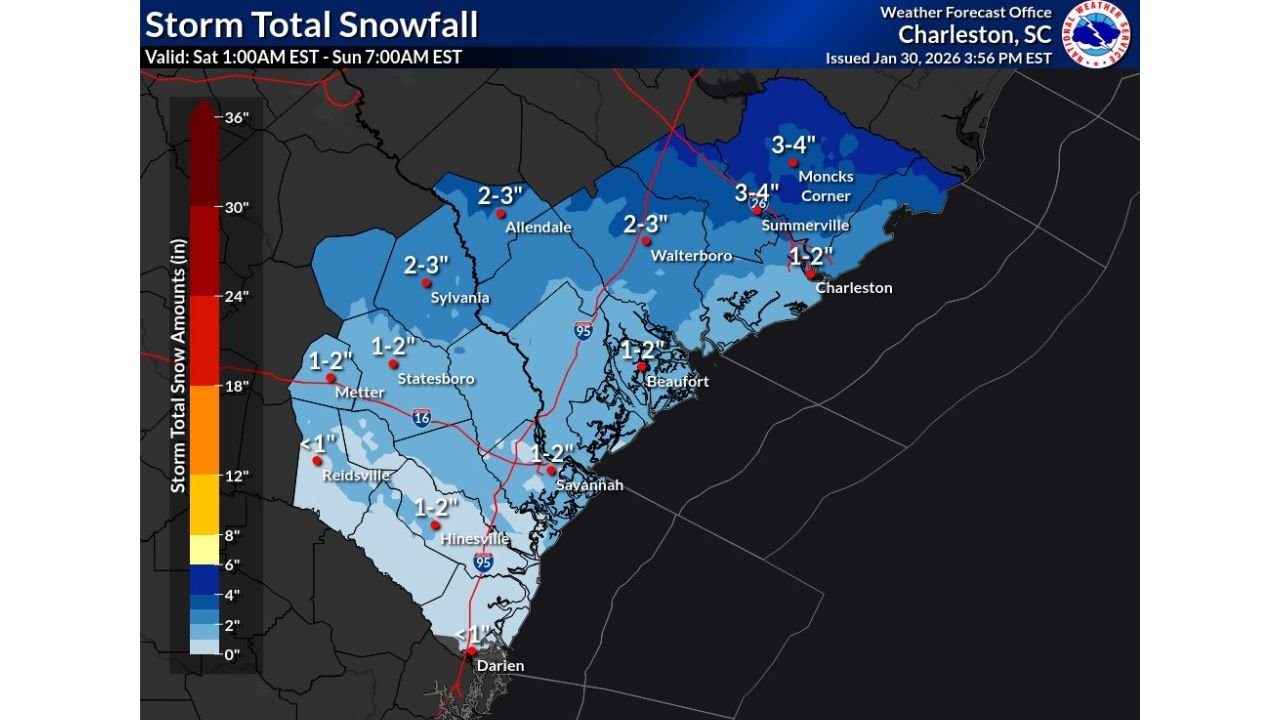
Offshore Low Brings Heavier Snow to Coastal South Carolina
SOUTH CAROLINA — While Alabama deals with lighter snow, the most dramatic winter setup is unfolding along the South Carolina coast, where a strong offshore low-pressure system is forecast to intensify early Sunday.
Snowfall projections from the Charleston Weather Forecast Office show:
- 3–4 inches possible from Moncks Corner to Summerville
- 2–3 inches near Walterboro and Allendale
- 1–2 inches for Charleston and Beaufort, with locally higher totals inland
This setup is rare for coastal South Carolina and is being driven by the perfect alignment of cold air and deep Atlantic moisture.
Coastal Georgia Sees Light but Impactful Snow
GEORGIA — Snow chances extend southward into coastal Georgia, where accumulation is expected to be lighter but still impactful.
- Savannah, Hinesville, and Statesboro are forecast to receive 1–2 inches
- Areas farther inland may see less than 1 inch, but icy conditions remain a concern
- Even small accumulations could cause travel disruptions due to freezing road surfaces
Snowfall is expected mainly overnight into early Sunday morning before tapering off.
Why This Winter Event Is Unusual
This system stands out because it combines:
- Deep Arctic cold pressing unusually far south
- A rapidly strengthening offshore low just east of the Carolinas
- Snow reaching areas that rarely see accumulation, especially near the coast
High-resolution models show a tightly wound circulation offshore, enhancing snowfall rates across coastal South Carolina while lighter bands extend west into Alabama and south into Georgia.
What Residents Should Do
- Avoid unnecessary travel during early morning hours
- Watch for black ice, especially on bridges and secondary roads
- Secure loose outdoor items due to strong winds
- Stay updated with local forecasts and advisories
Winter weather doesn’t often make headlines across the Deep South — but this storm is proving to be a rare and impactful setup.
For continued weather updates, regional forecasts, and storm breakdowns, keep checking ChicagoMusicGuide.com and share how conditions look in your area.