
Arctic Front Slams the Northeast Feb. 6–7, Bringing Snow Bands, Dangerous Winds, and the Coldest Air of the Season
UNITED STATES — A powerful Arctic front is charging through the eastern United States late Friday into Saturday, February 6–7, setting up a complex snow pattern across the Mid-Atlantic, Pennsylvania, New York, and New England, followed by brutal, season-coldest air and damaging wind chills. Forecast data points to narrow but intense snow bands, especially where an inverted trough develops, while most areas contend with howling winds and life-threatening cold through the weekend.
Arctic Front Arrival and Overall Setup
The incoming air mass originates deep in the Arctic and plunges southward late Friday, pushing a sharp cold boundary through the Mid-Atlantic and New England overnight. This is expected to be the strongest Arctic front of the winter so far for parts of the East, rapidly dropping temperatures and flipping rain or mixed precipitation to snow as it passes.
Behind the front, pressure rises sharply while a strong jet streak races overhead—an environment favorable for brief snow showers, localized bursts, and rapidly increasing winds.
Snow Showers and Commute Impacts Friday
As the front sweeps through Friday afternoon into early evening, hit-or-miss snow showers are possible from the central Appalachians into the Mid-Atlantic corridor. While many locations see only brief reductions in visibility, some spots may pick up a quick coating that creates slick roads—especially during the evening commute.
These showers are not expected to be uniform, but their timing and intensity could briefly disrupt travel before the colder air fully settles in.
Saturday Snow: Clipper System and Regional Totals
A weak clipper system follows the front into Saturday, spreading light snow across much of the region:
- Western Pennsylvania & higher elevations of eastern Pennsylvania:
Snowfall of 2–4 inches is likely. - Upstate New York (especially near Lake Ontario and north of the Thruway):
Lake enhancement could push totals above 4 inches, with some zones reaching 4–6 inches. - Southern New England:
Confidence is increasing that an inverted trough sets up somewhere between Hartford, CT and Boston, MA. Where this narrow feature locks in, snow totals could exceed 4 inches, and isolated pockets may approach 6 inches. - I-95 corridor (NYC to Boston):
Many locations fall into the 1–2 inch range, though amounts could vary sharply over short distances.
This is a high-gradient forecast, meaning snowfall can change significantly over just a few miles.
Inverted Trough: The Wild Card
High-resolution models are increasingly hinting at an inverted trough (IVT) forming on the leading edge of the cold air. Wherever this feature stalls—even briefly—it can focus lift and moisture into a very narrow snow band, producing 3–6 inches in a short time while nearby areas receive far less.
Exact placement remains uncertain, but southern New England and parts of eastern New York remain the most favored zones.
Wind Threat and Possible Power Outages
As the Arctic air deepens Saturday, winds ramp up dramatically:
- Widespread gusts: 35–45 mph
- Higher elevations & exposed areas: 45–55 mph possible
These winds, combined with powdery snow, may cause blowing snow, reduced visibility, and isolated to scattered power outages, especially in mountain and coastal regions.
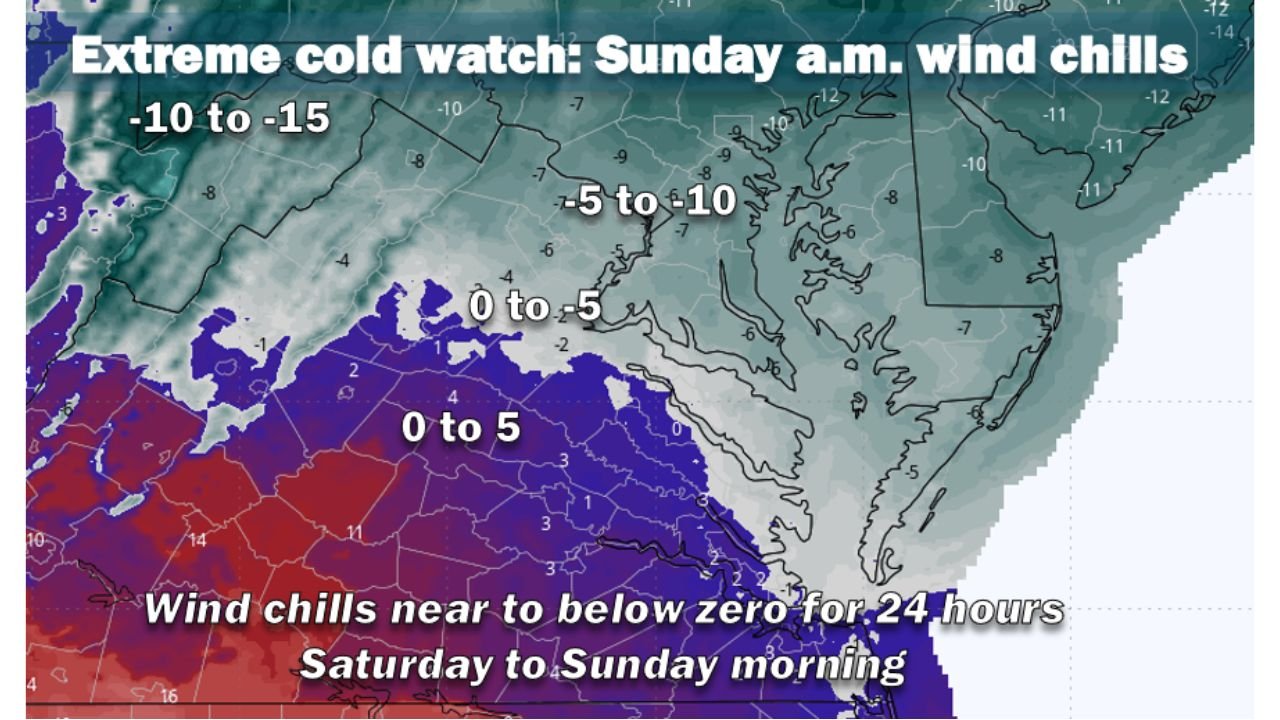
Extreme Cold and Dangerous Wind Chills
Once the snow ends, the real danger begins. Temperatures plunge into the teens by Saturday morning, with many areas struggling to rise out of the low 20s all weekend.
Wind chills will be severe:
- Saturday night into early Sunday:
Wind chills near or below zero across much of the Mid-Atlantic and New England. - Early Sunday morning:
Some areas could see wind chills down to −10°F, with the cold persisting for 24 hours or more.
Exposure risks are high, with frostbite possible in minutes if skin is left uncovered.
What to Expect Next Week
Looking ahead, confidence is growing that another storm system may impact the Eastern U.S. between February 11–14, potentially bringing a more widespread winter storm. While details remain uncertain, this could finally end the recent dry stretch for parts of the Northeast.
Bottom Line
This is a high-impact winter setup defined less by one big snowstorm and more by localized heavy bands, dangerous winds, and extreme cold. Small shifts in the setup will determine who sees plowable snow versus lighter amounts—but everyone feels the cold.
Stay prepared, limit exposure during peak cold, and monitor local updates closely as the event unfolds.
For continued weather updates, winter safety coverage, and how these conditions may affect upcoming shows and events, stay with ChicagoMusicGuide.com.