
California and the West Coast Brace for a Powerful Christmas-Week Storm Pattern Bringing Heavy Rain, Flooding Risks, and Mountain Snow
California — A Major Christmas-Week Pattern Shift Takes Shape, After nearly a month of unusually warm and dry conditions across the Desert Southwest and Southern California, a significant shift in the weather pattern is now developing just in time for the holiday period. Atmospheric indicators, Pacific satellite loops, and CPC guidance all point to a stronger, more aggressive storm track setting up and targeting the West Coast between December 22 and December 28.
This change is being driven by a weakening ridge over California and an increasingly active Pacific jet extension stretching from the western Pacific across the ocean toward the West Coast.
Stronger Troughing Will Allow Storms to Dig Deeper Into California
Forecast models show progressively deeper troughs arriving next week, pushing storms farther south with each passing day. This pattern will allow widespread unsettled weather to develop across:
- Southern California
- Central California
- Northern California
Initial impacts may begin around Christmas Eve, though some guidance suggests stormy conditions could arrive slightly earlier.
This shift will also feed on warmer-than-normal Pacific moisture, lifting snow levels at first before colder air behind each system lowers them again.
Warmer Pacific Moisture Could Raise Snow Levels Before They Fall
Moisture feeding into the storm system is expected to originate from tropical and subtropical regions, leading to elevated snow levels of 7,000–8,000 feet during the early phases of the event.
However, as colder air wraps in behind the stronger impulses, snow levels may drop, raising concerns for:
- Sierra travel delays
- Chain requirements
- Holiday-week mountain impacts
Multiple West Coast Regions Now on Alert
What began as a Southern California–focused pattern shift now appears likely to expand northward and impact the broader West Coast:
Northern California
Could see widespread rain, swollen rivers, and travel disruptions.
Central California
Potential for moderate to heavy rainfall and accumulating mountain snow later in the sequence.
Pacific Northwest (Oregon & Washington)
Already dealing with flooding, these states face continued moisture feeds influenced by the long-duration Marshall Islands low-pressure axis.
This multi-region alignment is increasing the rainfall risk across the entire West Coast.
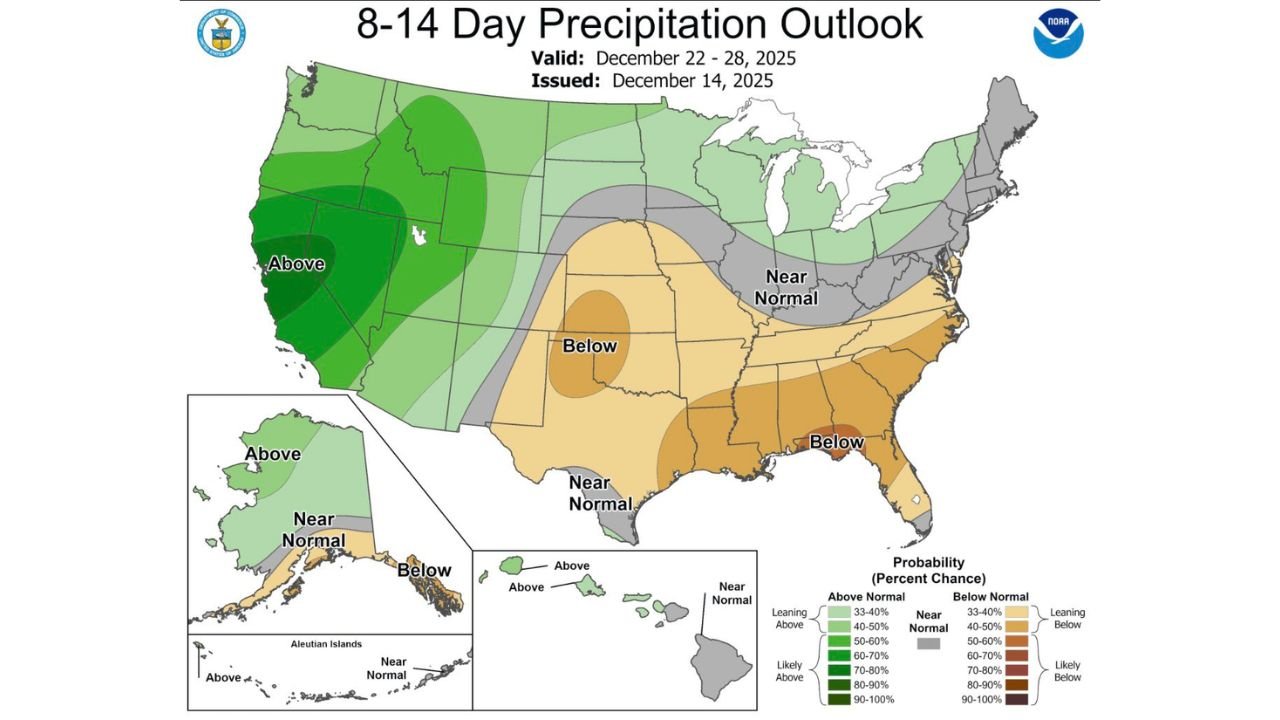
Long-Range Guidance Shows Elevated Precipitation Through December 28
The 8–14 Day Precipitation Outlook issued by the CPC strongly favors above-normal precipitation across:
- California
- Oregon
- Washington
- Northern Nevada
- Parts of the Desert Southwest
This supports the growing likelihood of a persistent storm train lasting through the end of December.
An advancing series of Pacific waves could deliver:
- Heavy rainfall
- Flooding concerns in saturated regions
- Mountain snow
- Strong winds along the coast
- Travel delays during peak holiday travel
Atmospheric River Potential Being Monitored
Early signals from the AR landfall probability tools indicate increasing chances of IVT ≥ 250 kg/m/s, suggesting that at least one storm within the Christmas–New Year window could reach atmospheric river strength.
A stronger AR event would significantly elevate the risks of:
- Urban flooding
- River rises
- Mudslides in recent burn scars
- Major mountain snow impacts
Hazards Outlook Flags Heavy Precipitation and Snow Across the West
The Days 8–14 U.S. Hazards Outlook highlights:
- Heavy precipitation along the California and Oregon coasts (Dec 22–29)
- Heavy snow in the Sierras, Cascades, and interior Northwest
- High-wind potential across sections of the West
These hazards align with the aggressive storm track forming across the Pacific.
If You Are Traveling for the Holidays
Anyone traveling into California’s mountain regions should be prepared for:
- Rapidly changing conditions
- Road closures
- Chain requirements
- Delays from heavy snow and reduced visibility
Even lower elevations could face significant rainfall impacts during one of the busiest travel weeks of the year.
Stay Weather-Ready With ChicagoMusicGuide.com
As this powerful West Coast storm pattern develops, ChicagoMusicGuide.com will continue providing clear, timely updates to help you stay prepared during the busy holiday season. Check back often for new storm details and regional impacts.