
California Sierra Nevada Braces for Potential 100+ Inches of Snow as 15-Day Model Outlook Turns Extreme
CALIFORNIA, UNITED STATES — A rapidly intensifying winter pattern across the Western U.S. is placing the Sierra Nevada mountains of California squarely in the spotlight, as long-range model guidance shows the potential for extraordinary snowfall totals over the next 15 days. Some ensemble members are producing more than 100 inches of cumulative snow, and the AIFS operational run highlights just how active this stretch could become.
While exact totals will fluctuate with each storm, the overall signal points toward a sustained and highly productive snow period, rather than a single isolated event.
AIFS Operational Run Shows Exceptional Sierra Snow Totals
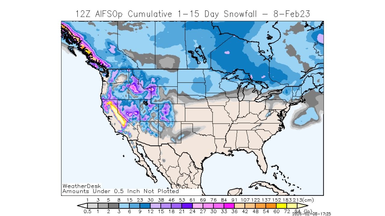
The 12Z AIFS operational cumulative snowfall forecast paints a striking picture for the Sierra Nevada. In favored terrain, snowfall totals push into the 70–100+ inch range over the 1–15 day window, with the highest amounts concentrated along the central and southern Sierra crest.
These totals reflect multiple snow-producing systems stacking on top of one another, driven by a colder and stormier Pacific pattern that funnels moisture directly into California’s mountain spine.
Why the Sierra Nevada Is the Primary Target
The Sierra Nevada’s orientation makes it especially vulnerable during prolonged Pacific storm cycles. Strong onshore flow combined with colder air aloft allows storms to:
- Maximize orographic lift
- Maintain efficient snow growth
- Keep snow levels favorable for accumulation at resort and high-elevation zones
With little time between storms, snowpack has limited opportunity to settle or melt, allowing totals to climb rapidly.
Broader Western U.S. Snow Signal Remains Strong
While the Sierra stands out, the same 15-day outlook also shows widespread snowfall across the Western United States, including:
- Northern and Central Rockies in Idaho, Montana, Utah, Wyoming, and Colorado
- Great Basin ranges of Nevada
- Pacific Northwest mountains of Washington and Oregon
This confirms that the Sierra snow threat is part of a larger-scale winter pattern shift, not a localized anomaly.
Impacts for Travel, Resorts, and Infrastructure
If even a portion of these projected totals materializes, impacts will be significant:
- Mountain pass closures and chain controls likely
- Back-to-back powder days for ski resorts
- Avalanche risk increases with rapidly loading snowpack
- Challenging travel conditions for Sierra communities
Resorts may benefit from exceptional mid- to late-season conditions, but travelers should prepare for frequent disruptions.
Why Confidence Is Higher Than a Typical Long-Range Forecast
While 15-day snowfall maps often carry uncertainty, confidence is elevated due to:
- Consistent ensemble support
- Strong agreement on a cold, active Pacific pattern
- Repeated storm timing signals
Exact placement of the heaviest bands will change, but the message of sustained heavy mountain snow is clear.
What to Watch Over the Next Week
Key factors that will refine totals include:
- Snow levels with each incoming system
- Storm spacing and intensity
- Wind-driven redistribution of snow
- Potential atmospheric river interactions
Even modest shifts could determine whether totals approach the upper-end 100-inch scenarios or settle lower — but still impressive.
A Defining Stretch for California’s Snow Season
This upcoming period has the potential to define the second half of winter across California’s Sierra Nevada, dramatically boosting seasonal snowpack and improving water supply prospects heading into spring.
As this high-impact pattern takes shape, staying informed will be critical. For continued Western U.S. winter forecasts, Sierra snow updates, and long-range model trends, visit ChicagoMusicGuide.com.