
California Storm Pattern Returns With Flood Risk Increasing Across California, Nevada, and Arizona as February Turns Active
CALIFORNIA — A renewed and increasingly active storm pattern is setting up across California and the broader Western United States, with the latest Climate Prediction Center (CPC) outlooks highlighting a growing risk for above-normal precipitation and potential flooding during the February 14–21, 2026 period.
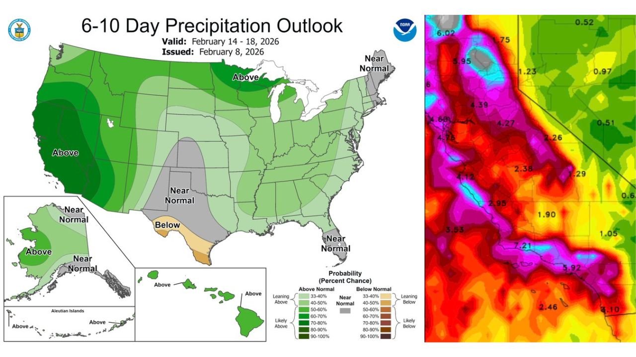
Updated CPC guidance issued Sunday evening shows California squarely in the core of an above-normal precipitation zone, signaling a notable shift away from recent quieter conditions. This transition aligns with a strengthening Pacific jet stream and a broader large-scale pattern change favoring repeated storm systems impacting the West Coast.
CPC Outlook Highlights California as Primary Precipitation Focus
The 6–10 Day Precipitation Outlook places most of California in a strong above-normal precipitation category, with probabilities increasing along the coast and extending inland through the Sierra Nevada and parts of the Central Valley.
Neighboring states including Nevada, Arizona, and portions of Oregon also show elevated precipitation signals, though California remains the most consistently highlighted area across multiple datasets. This alignment suggests not just a single storm, but a multi-day storm sequence capable of producing meaningful rainfall totals.
High-Resolution Rainfall Guidance Shows Potential for Heavy Totals
High-resolution rainfall output accompanying the CPC outlook reveals locally heavy rainfall amounts across Northern, Central, and Southern California, particularly along west-facing terrain and foothill regions.
Several zones show multi-inch rainfall potential, especially where storms repeatedly track over the same areas. This raises concerns for urban runoff, small-stream flooding, and mudslide risk in recent burn scar regions. While exact totals will depend on storm timing and intensity, the signal for impactful rainfall is clear.
Jet Stream and Pattern Shift Drive February Storm Surge
Meteorologically, this pattern is being driven by a powerful Pacific jet extension and a shift toward a negative Pacific-North American (PNA) configuration, a setup historically associated with active West Coast storm tracks.
With the polar vortex displaced northward and Pacific energy dominating, storms are able to tap into deeper moisture and move efficiently into the state. February often represents a climatological peak for California storm activity, and current signals suggest this year is following that script.
Flooding and Travel Impacts Become Increasingly Possible
While not every storm will be extreme, the cumulative effect of multiple systems raises the likelihood of flooding concerns, particularly in low-lying areas and along rivers and creeks. Mountain regions could see heavy precipitation, with snow at higher elevations and rain at lower levels contributing to runoff.
Travel through mountain passes, coastal highways, and urban corridors may become impacted during periods of heavier rainfall. Residents are urged to remain aware of changing forecasts as the mid-February window approaches.
What to Watch Next
The CPC outlook represents a high-confidence precipitation signal, not a day-by-day forecast. Short-range models over the coming days will refine storm timing, rainfall totals, and flood risk locations.
For now, the takeaway is clear: California is entering a more active and wetter phase, with February shaping up to be a critical period for precipitation across the state and surrounding regions.
Stay tuned to ChicagoMusicGuide.com for continued weather updates, storm analysis, and regional impact breakdowns as this evolving pattern takes shape across the West.