
California’s Sierra Nevada Snowpack Collapses Compared to March 2025 as Sacramento, Reno, Fresno and Los Angeles Face Early Fire Season Warning
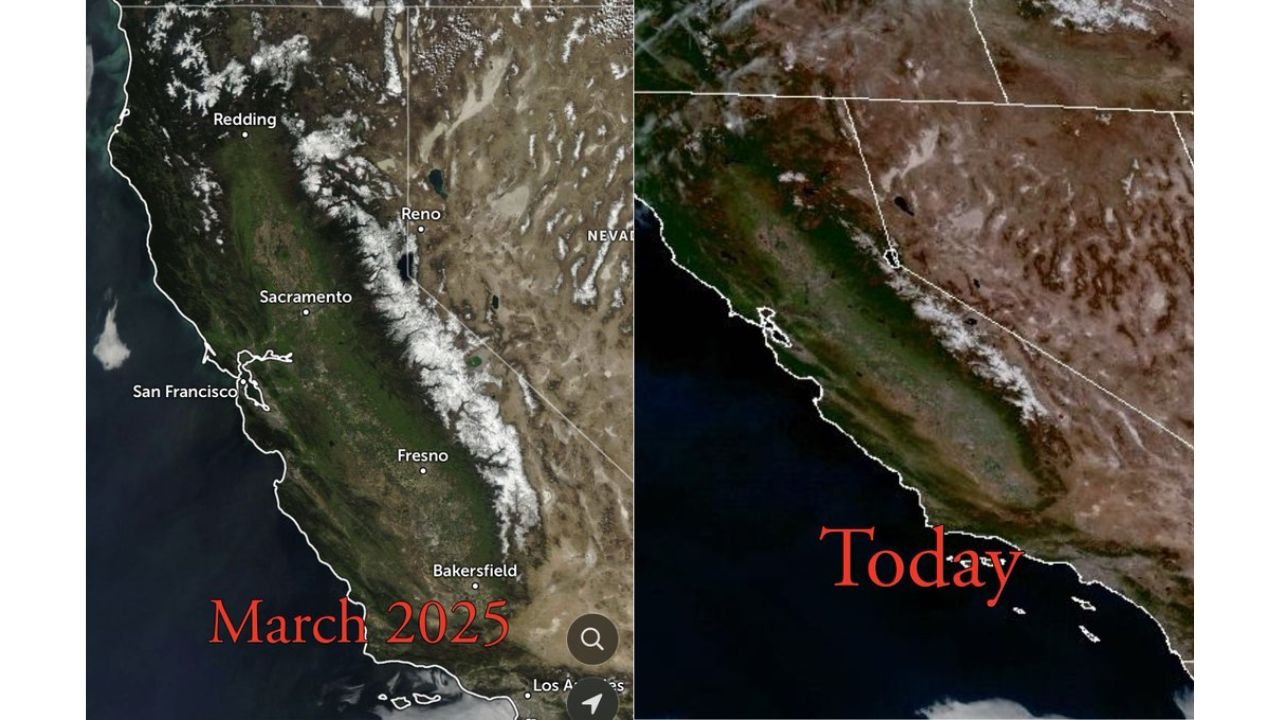
SACRAMENTO, CALIFORNIA — A striking satellite comparison between March 2025 and this spring reveals a dramatic and troubling shift across California and western Nevada, with the Sierra Nevada snowpack appearing significantly reduced compared to the same time last year.
Imagery highlighting cities such as Redding, Sacramento, San Francisco, Fresno, Bakersfield, Reno, and Los Angeles shows a clear difference: where widespread white snow coverage once blanketed the Sierra crest in March 2025, much of that snow is now sparse, patchy, or absent.
A Stark Year-to-Year Contrast
Last March, the Sierra Nevada displayed a robust snowpack stretching from northern California near Redding southward past Fresno and toward the southern Sierra. The mountain chain appeared bright and continuous, indicating healthy seasonal accumulation.
In contrast, current imagery shows noticeably thinner coverage. Large portions of the range that were previously snow-covered now appear brown or exposed, particularly along the central and southern Sierra.
The reduction is visually evident near the California–Nevada border around Reno, where mountain snow coverage appears fragmented compared to the solid blanket seen one year earlier.
Minimal Snowpack Raises Red Flags
The Sierra Nevada snowpack plays a crucial role in California’s water supply. Spring snowmelt feeds reservoirs and rivers that support agriculture, urban areas, and ecosystems across the state.
When snowpack levels are minimal heading into late spring, two major concerns emerge:
- Reduced water availability later in summer
- Earlier drying of vegetation and fine fuels
Satellite imagery also shows increasing areas of brown and muted green tones across interior California, suggesting that grasses and lower-elevation vegetation may be drying earlier than normal.
Signs of Early Fuel Curing
Meteorologists and fire-weather specialists are noting clear signs of fine fuels curing across portions of California. Curing refers to the drying of grasses and small vegetation that can ignite easily.
With less lingering snow in the mountains and warmer temperatures accelerating drying, the stage may be set for an earlier-than-average start to fire season in parts of the state.
Areas from the Sacramento Valley through the San Joaquin Valley, including Fresno and Bakersfield, could see elevated fire weather conditions sooner than typical if dry patterns persist.
Broader Implications for the West
The reduced snowpack does not only affect California. Western Nevada, particularly around Reno, also relies on Sierra snowmelt for water resources.
Additionally, lower snow cover can amplify regional warming trends by reducing surface reflectivity. Snow normally reflects sunlight; without it, darker ground absorbs more heat, potentially reinforcing warm and dry conditions.
A Developing Story as Spring Advances
While a single satellite comparison does not determine the entire seasonal outlook, the visual contrast between March 2025 and this year is unmistakable. The Sierra Nevada — often California’s natural reservoir — is entering spring with noticeably less snow coverage.
If dry weather continues and temperatures remain above normal, fire agencies across California may begin preparing for heightened wildfire potential earlier than usual.
Residents across Northern and Central California, western Nevada, and the Sierra foothills should remain aware of evolving fire weather conditions as spring progresses.
For continuing coverage of major national weather trends and climate contrasts, stay with ChicagoMusicGuide.com.