
Powerful Upper-Level Trough Digs Into Central U.S., Setting Stage for Intensifying Storm From Texas to the Mid-Atlantic
CENTRAL UNITED STATES — The upper atmosphere is beginning to reorganize in a significant way as a shortwave disturbance rounds the base of a developing trough, helping it dig and intensify across the central part of the country.
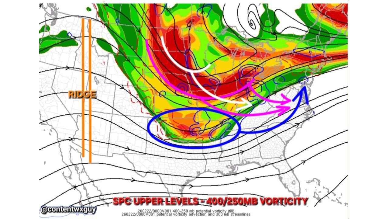
New upper-level analysis at the 400–250mb layer shows increasing vorticity energy stretching from the Rockies into the Plains and Midwest, signaling that the system is gaining strength as it pushes eastward.
Trough Deepens Across the Rockies and Plains
The graphic highlights a pronounced upper-level trough carving southward through the western and central U.S., with a strong ridge positioned along the West Coast.
As the shortwave energy rotates around the base of the trough — particularly across New Mexico, Texas, and Oklahoma — the system begins to consolidate and amplify. This process allows the trough to:
- Dig farther south
- Strengthen dynamically
- Increase upward motion downstream
That upward motion is crucial for storm development across the Mississippi Valley and eventually into the Ohio Valley and Mid-Atlantic.
Energy Transfer Toward the Midwest and East
As the northern disturbance drops in and interacts with the southern energy, the trough becomes more negatively tilted — a configuration often associated with strengthening surface lows.
Upper-level wind streamlines indicate a strong southwest-to-northeast flow pattern from Texas toward the Ohio Valley and Mid-Atlantic. This alignment supports moisture transport and increasing lift ahead of the trough axis.
States potentially influenced by this evolving setup include:
- Texas
- Oklahoma
- Arkansas
- Missouri
- Illinois
- Indiana
- Kentucky
- Tennessee
- Ohio
- Pennsylvania
- Virginia
The exact impacts will depend on surface low placement and thermal profiles, but the upper-level pattern strongly supports intensification.
Surface Low Development Likely
With strong upper divergence and vorticity advection in place, the pattern favors a strengthening surface low somewhere from the southern Plains into the lower Mississippi Valley.
As that low lifts northeast, precipitation bands are expected to expand and organize. Depending on temperature profiles, this could mean:
- Rain across southern zones
- Snow or mixed precipitation north of the track
- Increasing wind potential as the gradient tightens
The upper-level support shown in the data suggests this will not be a weak or disorganized system.
Why the Upper Levels Matter
While surface maps show immediate impacts, upper-level dynamics determine how strong and organized a storm becomes. The digging trough and incoming northern disturbance provide the “fuel” aloft.
When shortwave energy rounds the base of a trough and begins interacting with northern-stream energy, it often signals:
- Rapid pressure falls
- Enhanced precipitation rates
- Sharper rain/snow boundaries
- Stronger wind fields
This setup is still evolving, but the upper-level pattern clearly shows the atmosphere “starting its magic,” as dynamic forcing increases across the central U.S.
What to Watch Next
Key factors to monitor over the next 24–48 hours include:
- The exact track of the surface low
- How far south the trough digs
- The timing of northern-stream interaction
- Temperature profiles across Illinois and the Midwest
Small shifts aloft can produce major changes at the surface.
As this developing trough continues to dig and steepen, impacts from the southern Plains to the East Coast will become clearer. For continued coverage on evolving Midwest and national weather patterns, visit ChicagoMusicGuide.com.