
Central U.S. Warms Up While West and East Coast Stay Cooler as February Outlook Shifts Across Multiple States
UNITED STATES — A new multi-week temperature outlook for February 2026 reveals a clear divide forming across the country, with much of the Central United States expected to run above average, while both the Western states and the Eastern Seaboard fluctuate between near-average and below-average temperatures as the month progresses.
Forecast guidance covering Weeks 1 through 3 highlights how evolving atmospheric patterns could reshape weather conditions from California and the Pacific Northwest to Illinois, Texas, and the Northeast, impacting everything from daily routines to travel and large outdoor events.
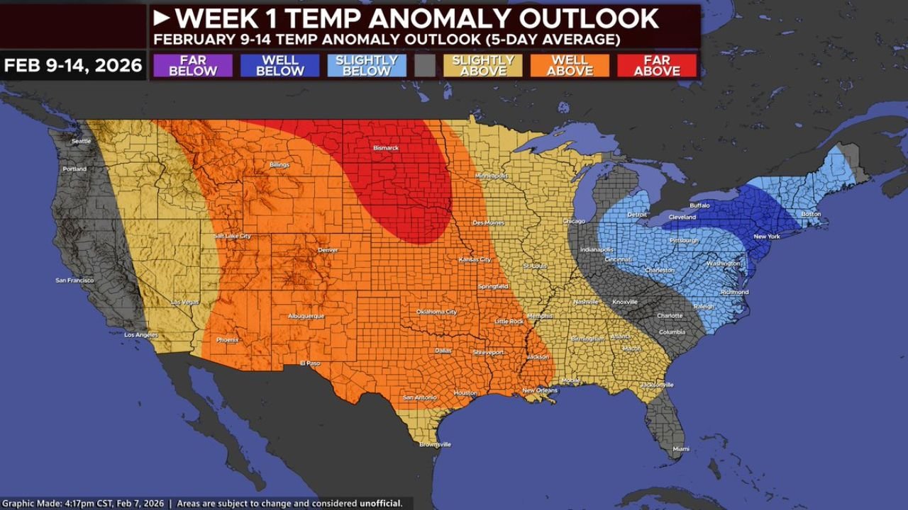
Week 1 Outlook Shows Widespread Warmth Across Central States
During Week 1 (February 9–14), temperature anomaly maps indicate that a large portion of the Central U.S. will experience above-average warmth.
States most likely to see milder-than-normal conditions include Texas, Oklahoma, Kansas, Missouri, Arkansas, Nebraska, and much of the Midwest, including Illinois and Iowa. These areas fall within zones marked slightly above to well above average, signaling a temporary break from sustained winter cold.
In contrast, Western states such as California, Oregon, Washington, and parts of Nevada trend closer to seasonal norms, while portions of the Eastern U.S. — including Pennsylvania, New York, West Virginia, and New England — remain closer to or slightly below average.
Week 2 Keeps Central U.S. Warm While Coastlines Cool
The Week 2 outlook (February 14–19) continues this pattern, with warm anomalies persisting across the Plains and Mississippi Valley.
Much of Texas, Louisiana, Mississippi, Tennessee, and the central Midwest remains above average, while the East Coast from Georgia through the Carolinas and into the Northeast shows a growing signal for near-average or slightly cooler conditions.
Out West, below-average temperatures become more prominent across California, Oregon, Washington, Idaho, and Montana, reflecting deeper troughing over the North Pacific that funnels cooler air inland.
Week 3 Pattern May Bring Colder Air Back to the West and East
By Week 3 (February 19–26), the outlook becomes more complex, but a broader signal begins to emerge.
Forecast guidance suggests the negative Pacific-North American pattern (-PNA) may remain in place, favoring cooler-than-average temperatures across the Western United States, especially California, Oregon, Washington, Utah, and Arizona.
Meanwhile, the Central U.S., including Texas, Oklahoma, Missouri, and parts of the Midwest, is still expected to remain at least slightly above average, though not as warm as earlier in the month.
If troughing redevelops over the Eastern U.S., supported by a negative Arctic Oscillation (-AO) and North Atlantic Oscillation (-NAO), colder air could return to Pennsylvania, New York, New Jersey, Massachusetts, and surrounding states, reinforcing winter conditions late in the month.
What This Means for Travel, Events, and Outdoor Plans
This evolving setup creates sharp temperature contrasts across the country, which can complicate planning for travel, outdoor festivals, and major events.
For regions like the Midwest and Central Plains, the warmer stretch could improve road conditions and reduce snow-related disruptions. However, colder trends in the West Coast states and Eastern states could still bring periodic winter hazards, especially if storm systems align with returning cold air.
For outdoor events — including major sporting weekends, concerts, and festivals — flexibility will be key, particularly in Florida, Georgia, the Carolinas, and the Northeast, where temperature swings remain possible.
Forecast Confidence Remains Moderate Beyond Mid-Month
Meteorologists caution that while Week 1 and Week 2 signals are relatively strong, Week 3 confidence remains lower, as long-range patterns can shift quickly.
Small changes in jet stream placement or teleconnections like the AO, NAO, and PNA could significantly alter which states see colder or warmer conditions as February winds down.
As February continues to unfold, weather patterns across the United States remain dynamic, with the Central states holding warmth while the West and East watch for colder turns. For continued updates on how shifting weather patterns could impact concert travel, outdoor venues, and major events, visit ChicagoMusicGuide.com for the latest forecasts and regional breakdowns.