
Dangerous Arctic Cold Continues Across Illinois, Midwest, Southeast and Northeast With One More Severe Night Before Retreat
UNITED STATES — The dangerous Arctic cold air mass that has affected large portions of the eastern United States for several consecutive days will persist for one more night, according to the latest national forecast data, before beginning to retreat later this week. The cold has produced widespread dangerously low temperatures and sub-zero wind chills, extending from the Upper Midwest through the Great Lakes, Ohio Valley, Appalachians, Southeast, and into Florida.
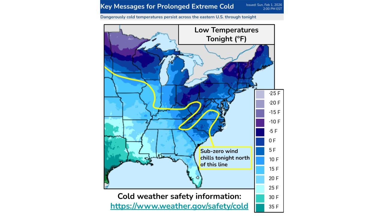
Arctic Air Remains Entrenched Through Tonight
Forecast data shows Arctic air remaining entrenched across the Eastern U.S. through Monday, marking the final night of this prolonged cold event. The persistence of the cold has led to widespread daily record low temperatures, with some locations facing the possibility of all-time February low temperature records, particularly across the Southeast and Florida.
Temperatures tonight across much of the region are expected to fall into:
- Single digits and teens across the Midwest and Great Lakes
- Near or below zero wind chills across portions of the Ohio Valley and Appalachians
Dangerous Wind Chills Extend Deep Into the Southeast
Strengthening winds behind a recent coastal storm are driving dangerously low wind chills, with forecast data indicating sub-zero wind chills extending southward into the Southern Appalachians and parts of the Southeast.
These conditions are considered especially concerning in areas where:
- Cold exposure has lasted multiple days
- Ongoing or recent power outages remain an issue
The data highlights that wind chill values tonight will remain below zero north of a defined boundary stretching across the eastern U.S., placing millions under continued cold exposure risk.
Florida Faces Rare and Prolonged Freeze Conditions
One of the most significant aspects of this Arctic outbreak is its impact on Florida.
Forecast guidance shows:
- Rare long-duration hard freezes continuing along the Gulf Coast
- Freezing temperatures extending down the Florida Peninsula
- Potential statewide impacts to vulnerable populations and agriculture
These conditions are expected to persist through Monday, making this cold event notable for both its intensity and duration across Florida.
Low Temperatures Tonight Remain the Primary Hazard
Temperature maps for tonight indicate:
- Widespread single-digit lows across the Midwest and Great Lakes
- Teens and low 20s across much of the Southeast
- Wind-driven apparent temperatures significantly colder than actual readings
The data confirms that tonight represents the final and most critical period of extreme cold before gradual moderation begins.
Cold Weather Safety Emphasized Until Cold Retreats
Safety guidance associated with this event stresses:
- Limiting outdoor exposure
- Ensuring pets and animals are protected from the cold
- Taking steps to prevent frozen pipes
- Avoiding travel on frozen bodies of water with unknown ice thickness
These precautions remain necessary through tonight, as Arctic air continues to dominate much of the eastern United States.
While the data indicates retreat of the Arctic air mass later this week, tonight remains a high-risk period for cold-related impacts across Illinois, the Midwest, Southeast, and Northeast.
Stay with ChicagoMusicGuide.com for continued coverage as conditions begin to shift and February’s weather pattern evolves.