
Dangerous Sunday Severe Weather Outbreak Expands Across Illinois, Missouri, Arkansas, Mississippi and Alabama as Enhanced Risk Grows and Squall Line Targets Ohio Valley After Dark
ST. LOUIS, MISSOURI — Confidence is increasing that a significant severe weather outbreak will unfold Sunday across the Mississippi River Valley, as the Storm Prediction Center has expanded and intensified its Enhanced Risk area ahead of a powerful, fast-moving squall line expected to stretch from Illinois to Texas.
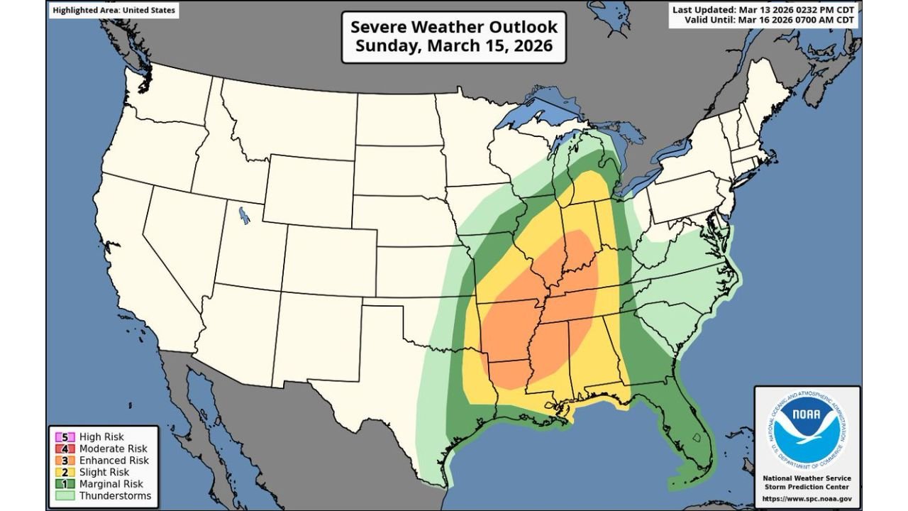
The latest outlook shows a broad swath of Enhanced Risk (Level 3 of 5) centered from eastern Arkansas and northern Mississippi through western Tennessee and into southern Illinois and western Kentucky, with surrounding Slight and Marginal risk zones extending outward across much of the Lower Mississippi Valley and parts of the Midwest.
Widespread Damaging Wind Event Likely
Forecasters are signaling that the primary hazard will be widespread damaging winds as a large, organized squall line develops and surges eastward through the day.
This line is expected to:
- Extend from southern Illinois and Missouri
- Sweep through Arkansas and Mississippi
- Stretch southward toward eastern Texas and Louisiana
Such a setup typically favors long-track wind damage events, with embedded circulations capable of producing locally higher-end gusts.
Given the strength and length of the projected line, power outages and tree damage could become widespread in some areas.
Tornado Threat Embedded Within the Line
While damaging straight-line winds appear to be the dominant risk, tornadoes remain a serious concern — particularly within embedded rotating segments along the squall line.
Discrete storms that form ahead of the main line could also briefly intensify before being overtaken, further increasing localized tornado potential.
The Enhanced Risk corridor includes communities such as:
- Little Rock, Arkansas
- Memphis, Tennessee
- Jackson, Mississippi
- Paducah, Kentucky
- Southern Illinois near Carbondale
These areas sit in the heart of the strongest projected instability and wind shear overlap.
Evening and Overnight Concern for the Ohio Valley
One of the most troubling aspects of this setup is timing.
Forecast guidance indicates the squall line will push into portions of the Ohio Valley after sunset, raising the risk for nighttime severe storms.
Areas including western Kentucky, southern Indiana, and parts of Ohio could experience storms during late evening hours when visibility is reduced and residents are less likely to receive warnings promptly.
Nighttime severe weather historically increases the danger due to limited visual confirmation and sleeping populations.
Large Geographic Footprint
The broader severe risk area spans a significant portion of the eastern half of the United States, including:
- Illinois
- Missouri
- Arkansas
- Mississippi
- Alabama
- Western Tennessee
- Western Kentucky
- Eastern Texas
- Louisiana
Peripheral risk extends into parts of Indiana, Ohio, and the Deep South.
The scale of this event suggests impacts may be felt across multiple states within a relatively short window of time.
Now Is the Time to Prepare
With the Enhanced Risk expanding and forecast confidence increasing, officials are urging residents across the Mississippi River Valley to review severe weather safety plans.
Key preparation steps include:
- Ensuring multiple ways to receive warnings
- Identifying safe shelter locations
- Charging electronic devices
- Securing loose outdoor objects
This system has the ingredients to produce a widespread damaging wind event with embedded tornadoes, and its rapid progression could leave little time to react once warnings are issued.
Sunday is shaping up to be an active and potentially dangerous day across the heart of the country.
Stay with ChicagoMusicGuide.com for continuing updates as this evolving severe weather threat approaches.